Skip to content
Loudoun Weather

Loudoun Weather

Weather forecasts and information for all of Loudoun County, Virginia. Including Leesburg, Aldie, Waterford, Ashburn, Sterling, Dulles, Hamilton, Purcellville, South Riding. Loudoun Weather is your source for Loudoun County weather forecasts, weather radar and more.

  • Home
  • OCC
  • Forecast
    • Aldie
    • Leesburg Virginia Weather
  • Radar
  • Severe
  • Precip
  • Conditions
  • Temps
  • Tropical
  • Winter
    • 2025 List of Winter Outlooks
    • Winter Impact Index
    • Snow Reports and Depth
    • Ice Impact
    • Ice
  • Articles of Interest
    • So why so hot? What causes heat in the Mid-Atlantic?
    • 10 ways to keep your home cool and save money!
    • June 29th, 2012 Derecho
  • Tweets
  • Toggle search form

Month: October 2021

What will Impact Winter 2021 -2022 – #5 Ocean and Great Lakes Temps

Posted on October 28, 2021November 10, 2021 By admin No Comments on What will Impact Winter 2021 -2022 – #5 Ocean and Great Lakes Temps

The Mid-Atlantic has a lot of factors because of the proximity to the Atlantic Ocean, Mountains, and even the Great Lakes. I want to outline the impacts of these AND the Pacific which will all impact this winter, especially early in the year!

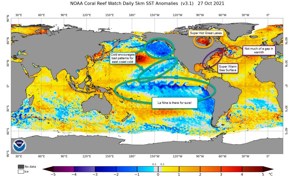
Atlantic Temps are WAY WARM!

The Atlantic Ocean is currently much warmer than normal. I think this will impact us in several ways:

  1. Storm systems will have a lot more moisture to work with! The heat should evaporate more moisture and juice up any storm system. This is part of why I think each time the forecast models say it will be a dry period, they back off pretty quickly
  2. The Western Atlantic Ridge (which at times is known as the Bermuda High) will be strengthened by the warmer air. This could slow the infiltration of colder air and stall fronts away from the coast and make them just inland. This could have a significant effect on the rain/snow line!
  3. Warmer temps from the ocean will also make marginal (close to frozen events) more likely to be a mix or even rain. That heat will make it inland! This becomes less of a factor for the western zones, but does impact the upper levels which could make sleet and freezing rain a problem. This is not new, but could be a more common set up

The Greenland Temperature Gap

There is often a cold pool off the Northeastern United States that is linked, many times, to a better negative NAO (See previous posts for information on the NAO)

Great Lakes

You would not think the Great Lakes would have too much impact on our weather, but it really does! The Great Lakes can provide additional moisture to some storm systems, and, if it is warm, it can help moderate temps that are being impacted by winds that go across them. I am not saying this is a huge factor, but it does have an impact.

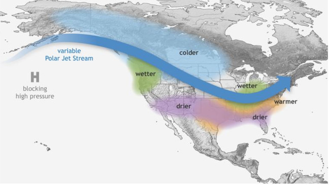
The Pacific Looks Poor

Probably one of the worst looks I have seen in a long while. The colder weather will encourage cold storms and the Jet Stream to be in a poor setup for us. I will discuss the Pacific Decadal Oscillation, the Pacific North American weather patterns, and the Eastern Pacific Oscillation in a post soon. All I can say is the pattern will favor milder terms for us and drier than normal conditions. I just do not like it.

Of course, we also have La Nina which will not bode well for big storms.

Summary

Most of the ocean looks terrible for us for winter. It is also the biggest signal that the winter may be warmer than normal and have less snow.

Forecast

What will impact Winter 2021 – 2022 #3 Snow Advance Index (SAI) & #4 North Atlantic Oscillation(NAO) and Atlantic Oscillation (AO)

Posted on October 27, 2021November 10, 2021 By admin No Comments on What will impact Winter 2021 – 2022 #3 Snow Advance Index (SAI) & #4 North Atlantic Oscillation(NAO) and Atlantic Oscillation (AO)

Snow Advance Index

The Snow Advance Index is a feature that is not always the best indicator for how our winter will be. The basic principle is that the advancement of snow cover in October is closely linked to the phase of the North Atlantic Oscillation.

North Atlantic Oscillation

The North Atlantic Oscillation (NAO) measurement is a KEY FEATURE needed to help get snowstorms on the East Coast of the United States. For example, the NAO is currently negative, which helps to slow down and aid in the development of big Nor’easters like the one we are having this week (October 26 – 27, 2021)

Really, though, the negative NAO (NAO-) is not the key to these storms, it is as the NAO flips back and forth between the negative and positive (NAO+) that usually signals a storm

Anyways, when the Snow Advance Index shows a great increase, the NAO *COULD* end up being more negative for the winter.

So what is the Snow Advanced Index Looking Like?

Snow Progression


The index is actually below where I would like to see it, but it is higher than last year!

imageywstm.png
Source – https://www.aer.com/science-research/climate-weather/arctic-oscillation/

The NAO Has been running Negative for a long while now. We will see if this can continue into November and Beyond! That would be a good sign for offsetting the La Nina impacts. (The line is below the 0)

NAO Index
NAO Index from Climate Prediction Center

Arctic Oscillation

Another factor for colder conditions is the Arctic Oscillation! As noted yesterday, when the Polar Vortex gets disrupted, it can turn negative! WE NEED THE NEGATIVE (if you like snow)! That is a better indication for more snow in the east! It has been running back and forth between positive and negative phases. We will see how this works out, but it looks like it is heading to negative again so the colder long-range seems to be linked to this as well! (Observed in black and red the various model predictions)

I am not super convinced we get non-stop help from the Arctic Oscillation this year, but I do expect a lot of variabilities which could help us at times be colder and have a chance of winter weather.

In Summary

I do not think we have much to count on from the Snow Advanced Index, North Atlantic Oscillation, or Arctic Oscillation. The negative NAO has been encouraging, but that alone will not set us right for winter weather.

Forecast

Winter Outlook Factor #2 – Polar Vortex Strength

Posted on October 26, 2021November 10, 2021 By admin No Comments on Winter Outlook Factor #2 – Polar Vortex Strength

The Polar Vortex is not something new and makes visits into the Lower 48 states every winter. The news media LOVES to over hype when it comes into play for the United States. Additional names to this Arctic region airmass could be the Polar Express (the streams of air that bring in the Vortex, or at least portions of it), or the circumpolar vortex.

What is it exactly?

The polar vortex is a large area of low pressure and cold air surrounding both of the Earth’s poles. (that comes straight from the NWS) In the winter it strengthens.

When it is very circular, it is considered stable and the jet stream is usually very strong. Storms likely will rip across the United States and the coldest air stays “locked” in Canada.

Polar vortex Information from Climate.gov

Disruptions

If you want there to be colder air masses in the United States, you would want the Polar Vortex to be weaker than normal so that storm systems can disrupt and dislodge the colder air into the United States. Another thing that can help to split and disrupt the Polar Vortex is something known as Sudden Stratospheric Warming. This is warming above the vortex that can “split” the vortex in some situations. When it splits, this also will bring colder air into the lower latitudes. This does not always mean the United States! The Warming and Splitting can take some time and air masses and weather patterns can take some time to respond.

SO WHAT!! What about our winter?

Two things I am noticing this fall! The first is that the Polar Vortex appears weaker! Remember, this will allow for the influence of storm systems that could dislodge the colder air and give us cooler weather. I am also ALREADY SEEING THIS HAPPENING!

If you have been following me on the My Facebook “Speculations” I mentioned some “signals” that we could see some cold early. It was SPECIFICALLY related to the disruptions being forecast by models for November. The disruptions started showing on models two weeks ago and are now happening. It looks like this disruption pattern could come in a few waves in November! Some is coming into play next week, and some other long-range speculations show the middle of the month. Just because we get disruptions does not mean we will get cold here. That mid-month intrusion seems pointed towards the middle part of the country, and maybe down into Texas! Remember, when you get past 5 to 7 days in forecasting, the forecasts become much more speculative as the models may be failing to pick up on some things. HOWEVER, these Polar Vortex disruptions do seem likely, again, because the vortex is so weak. And, while in this stage, we could see some below normal spells in November! Snowflakes would not surprise me at some time. However, sustained cold air may be a challenge, as it should be, since it is so early in the colder months.

Forecast

Loudoun County Weather Outlook for Tuesday, October 26, 2021

Posted on October 26, 2021October 26, 2021 By admin No Comments on Loudoun County Weather Outlook for Tuesday, October 26, 2021

Summary

A very windy day ahead with wind advisories in effect from 12pm to midnight. Heavy rains are possible Friday. Halloween looks breezy but mostly sunny.

Loudoun County Weather Outlook for Tuesday, October 26, 2021

Short-Range Loudoun Weather Outlook

Looks sunny tomorrow. Cloudy Thursday and then rain Thursday Night through Friday with highs around 60. There is a chance of some flooding rains Friday.

Mid-Range Loudoun Weather

The weekend will have a good chance of rain Saturday. It looks dry and breezy for Halloween.

Weather Prediction Center Rain Forecast for the next 7 days

Long-Range Loudoun Weather Outlook
Description

6 to 10 Day Temperature Outlook from the Climate Prediction Center
6 to 10 Day Precipitation Outlook from the Climate Prediction Center
6 to 10 Day Precipitation Outlook from the Climate Prediction Center
8 to 14 Day Temperature Outlook from the Climate Prediction Center
8 to 14 Day Precipitation Outlook from the Climate Prediction Center
8 to 14 Day Precipitation Outlook from the Climate Prediction Center
Forecast

Winter Outlook 2021 – 2022 – FIRST FACTOR – La Niña

Posted on October 25, 2021October 25, 2021 By admin No Comments on Winter Outlook 2021 – 2022 – FIRST FACTOR – La Niña

The BIGGEST concern I have for below-normal snow this year is the presence of La Niña

What is La Niña?

La Niña is a cold pool of water in the equatorial Pacific region. When the equatorial Pacific is Warm (El Niño) this region can supply a strong sub-tropical jet stream and usually a better chance of big snowstorms due to the amount of moisture. Although El Niño winters are not particularly cold, if the timing is right, we can get some whoppers! YES, 2016 was an El Niño year, and we got the last HUGE storm then.

La Niña, on the other hand, tends to make the Jet to the north push milder air into our region. We are often in the Battle Zone between colder to the north and warmer to the south when storms come along. The storms tend to turn to a mix or rain if they have any wintry weather in them at all. In general, we end up being slightly above normal with temperatures. The Pacific Northwest tends to get blasted with rain and Mountain snows (Like the absolute bomb cyclone of a Low from this last weekend). That does not do us much favors for keeping it cold in the east, as we get a ridge of High Pressure (Southeastern US warmer high pressures) pumping warmer air here.

Typical La Niña Pattern:

Typical La Niña Weather Patterns

So this is Factor One for the 2021 – 2022 Winter weather outlook!

You can see in the National Weather Service’s Winter Outlook that they are weighing heavily on the La Niña pattern. If you have been watching the weather the last week or so, you can see that this is what the pattern has looked like!

2021 National Weather Service Winter Outlook (Temperatures)

And, I have to say, we have had a horrible set of winters when there is aLa Niña! I saw a meteorologist show that 60% produced below normal snow for the area.

My Thinking:

La Nina will have an early impact that will be offset by some other factors! So it WILL have an impact, especially through January.. but I think it will become less of a factor later in the year.

Also, there are a few reasons why we may see some early sneak peeks of winter in November and December, but they are unlikely to be long-lived.

That concludes part one of the Winter Weather impacts for 2021 – 2022 Loudoun Weather Winter!

Forecast

Posts pagination

1 2 3 Next
Latest Radar from the National Weather Service
National Weather Forecast from https://www.wpc.ncep.noaa.gov/#page=ovw
National Forecast from the Weather Prediction Center
Regional Precipitation
Precipitation Forecast from the National Weather Service
  • Instagram
  • YouTube
  • Facebook
  • Instagram
  • Facebook
  • YouTube

Join My Mailing List

Add My Alexa Skill

Loudoun Weather Outlook Alexa Skill

Listen To the Daily Outlook on Spotify

An error has occurred, which probably means the feed is down. Try again later.

Recent Posts

  • Loudoun County Weather Outlook for Friday, May 23, 2025
  • Loudoun County Weather Outlook for Thursday, May 22, 2025
  • Loudoun County Weather Outlook for Wednesday, May 21, 2025
  • Loudoun County Weather Outlook for Tuesday, May 20, 2025
  • Loudoun County Weather Outlook for Monday, May 19, 2025

Recent Comments

    Archives

    • May 2025
    • April 2025
    • March 2025
    • February 2025
    • January 2025
    • December 2024
    • November 2024
    • October 2024
    • September 2024
    • August 2024
    • July 2024
    • June 2024
    • May 2024
    • December 2023
    • October 2023
    • September 2023
    • August 2023
    • June 2023
    • April 2023
    • March 2023
    • February 2023
    • January 2023
    • December 2022
    • November 2022
    • October 2022
    • September 2022
    • August 2022
    • July 2022
    • June 2022
    • April 2022
    • February 2022
    • January 2022
    • December 2021
    • November 2021
    • October 2021
    • September 2021
    • August 2021
    • July 2021
    • June 2021
    • May 2021
    • March 2021
    • February 2021
    • January 2021
    • December 2020
    • July 2020
    • June 2020
    • May 2020
    • January 2020
    • December 2019
    • November 2019
    • October 2019
    • September 2019
    • August 2019
    • July 2019
    • June 2019

    Categories

    • Alerts
    • Forecast
    • Uncategorized

    Meta

    • Log in
    • Entries feed
    • Comments feed
    • WordPress.org

    Current Advisories for Loudoun County

    Copyright © 2025 Loudoun Weather.

    Powered by PressBook WordPress theme