⚠️⚡️Severe and Heavy Rain possible tomorrow!
🌤️ Happy Father's Day on the longest day of the Year!
Today will be nice with highs in the mid to upper 80s
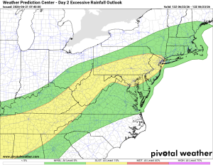
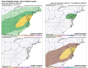
⛈️ Severe Threat Tomorrow
Monday brings a good chance of scattered showers and storms, with highs near 93. Some storms could become severe, with the potential for heavy downpours, strong winds, and even tornadoes.
🌤️ Quick Turnaround Tuesday
Maybe an isolated shower lingers into Tuesday, then highs settle into the low to mid 80s with a northerly breeze and lower humidity. Should be a really nice day.
🌦️ Rain Chances Return Late Week
Thursday brings rain chances back, around 50%, along with rising humidity again. Thursday, Friday, and Saturday all carry shower and storm chances, around 50% for Thursday and Friday, tapering off Saturday. Highs stay in the mid to upper 80s all three days.
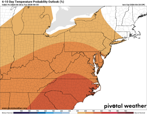
🔥 Heat Building Long Range
Looking further out, temperatures trend hotter than normal, so get ready for a return of summer heat.
The forecast:
Today: Hi 85 🌦️ 20% Lo 63 🌙 – Isolated morning showers, then sunny.
Increasing clouds overnight.
Monday: Hi 92 ⛈️ 90% Lo 64 🌧️ 80% – Scattered showers and thunderstorms
likely, becoming more widespread through the afternoon and evening.
Tuesday: Hi 82 🌦️ 20% Lo 59 🌙 – Isolated showers possible before 2pm
Wednesday: Hi 84 🌞 Lo 62 🌙 – Sunny and ncie.
Thursday: Hi 86 🌦️ 50% Lo 63 🌧️ 50% – Mostly sunny with a chance of
afternoon and evening showers and thunderstorms.
Friday: Hi 86 🌦️ 40% Lo 64 🌧️ 30% – Partly sunny with a chance of showers
and thunderstorms
Saturday: Hi 87 🌦️20% – Mostly sunny with a slight chance of showers.