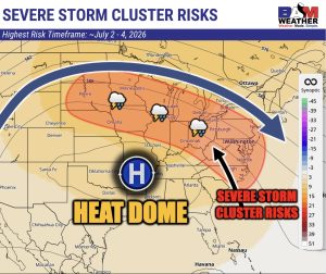
⚠️ Welcome rain and then, 🥵 A Heat wave on the way next week! 🌡️ Ring of fire pattern can bring clusters of storms on its edges, but that edge may shift north of what we see in the image ( BAM Weather – BAMWX.com on X created this great graphic)
🌞 Nice Day
Today's a decent day before the pattern shifts, warm with highs in the mid to upper 80s and a bit more humidity, bringing in some clouds. A late-day or overnight shower is possible but not widespread.
🌧️ Showers and Storms Move In
Friday turns hot with highs near 88 and showers and storms
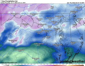
🌦️ Welcome Rain Saturday
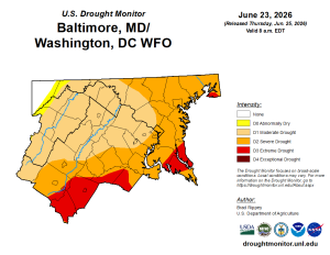
Saturday looks wet, which will be a big help for the ongoing drought.
☁️ Sunday Break
Sunday brings a chance of showers with highs in the low to mid 80s.
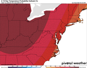
🔥 Heat Builds Next Week
The heat starts building Monday with highs near 90, then mid-90s Tuesday and upper-90s Wednesday, with heat index values exceeding 100. We're heading into a ring of fire pattern, and we'll be watching for severe thunderstorms to fire up along the edges of that heat late next week.
The forecast:
Today: Hi 87 🌦️ 20% Lo 65 🌧️ 20% – Mostly sunny with a slight chance of
afternoon showers
Friday: Hi 88 🌦️ 60% Lo 66 🌧️ 90% – Chance of showers and thunderstorms afternoon and night
Saturday: Hi 81 🌧️ 80% Lo 65 🌧️ 60% – Showers and possible thunderstorms
Sunday: Hi 84 🌦️ 20% Lo 65 – Mostly a partly sunny day with a slight chance
of afternoon showers and thunderstorms
Monday: Hi 88 ☀️ Lo 67 – Mostly sunny and getting hotter
Tuesday: Hi 95🌤️ Lo 71 – 🥵 Mostly sunny and hot!
Wednesday: Hi 98 🌡️ ☀️ – 🌡️ 🥵 Sunny and hot
#loudoun #loudouncountyva #vawx #loudounweather #loudounva #virginiaweather
Please support Tree of Life Ministries, an important organization to me!
Facebook: https://facebook.com/loudounwx
Twitter: https://twitter.com/loudounwx
Instagram: https://www.instagram.com/loudounweather/
On the Web @ https://loudounweather.com