1/22/2026 Major Winter Storm
I cannot help but note that it was ten years ago today that we experienced the Blizzard of 2016. That was the biggest snow I have ever seen, with 37 inches as best I could measure, and it was pure powder. It was a beautiful thing.
The setup for this storm
For the first time in many months, the southern jet stream will contribute to a storm system for our region. This has been the missing ingredient for big precipitation events and is why this storm brings such a strong chance of snow. Energy from the northern jet stream and southern jet stream will merge, or phase, helping to create a significant wintry event. How strongly these two systems combine is delicate.
If they combine too early or become too strong, warmer air will move overtop the cold air and bring more sleet and less snow. That looks very likely for areas from Richmond up to just south of Washington DC. Snow will fall first, then sleet will pile on top of it, creating a crusty layer. This warm air aloft intrusion will slowly progress north and west and will likely impact Loudoun. Areas farther east will see it first, but I suspect all of us will experience a period of sleet.
As of now, sleet looks like it will mark the end of the storm, with most of the significant precipitation already fallen. However, warm air is sneaky and often arrives sooner than snow lovers would like. Because of this, there is a wide range of possible outcomes, all dependent on how that warmer air behaves.
If we remain snow, we will be well into double digit totals. As of now, we have no idea how impactful the warm air aloft intrusion will be. Short range models over the next 24 hours will begin to give us clues. If the storm remains less merged or phases slowly, the warmer air may not make it as far north. That is still a possibility. Fine tuning snow amounts will be a challenge.
This is a huge winter storm
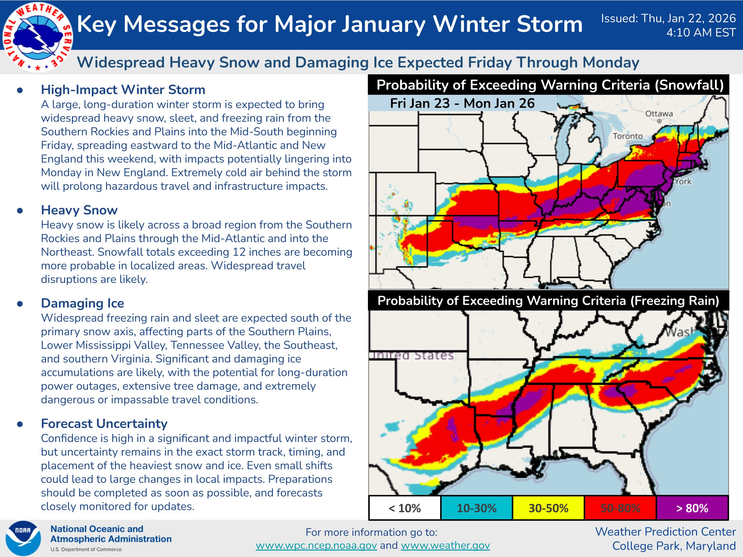
This will be a seriously impactful storm due to ice from Texas eastward to the East Coast, with a wide swath of heavy icing. That heavy icing will reach central Virginia, especially south of Richmond. This will lead to states of emergency and will impact all of us due to disrupted supply routes and the effects of prolonged cold.
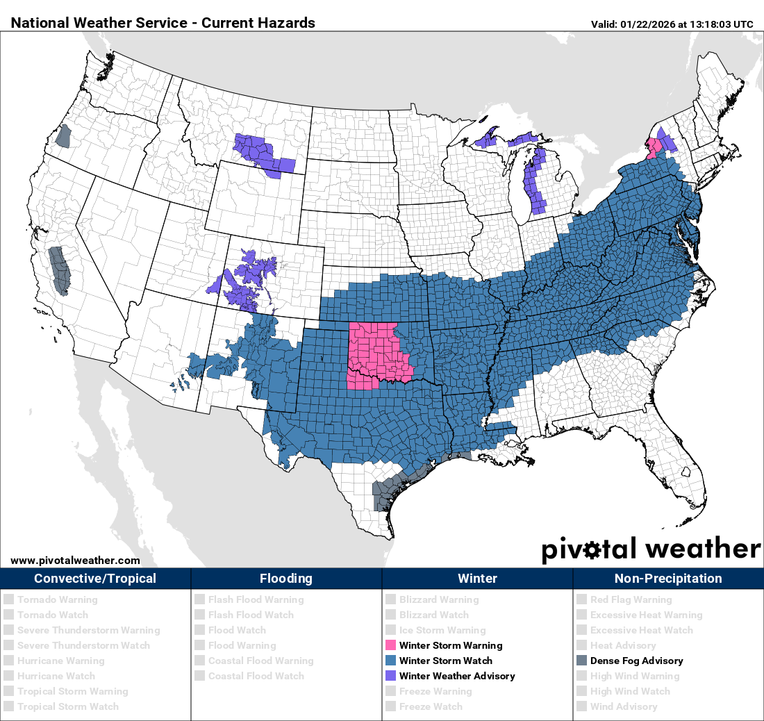
The areas hardest hit by ice will have the greatest needs for electricity restoration and supplies. I have attached the national watches map below. This is a massive area being impacted by this storm.
Timing
I would not be surprised to see light snow begin by early Saturday evening. Overnight Saturday and through the first half of Sunday, snow will fall heavily. Rates of one to two inches per hour are possible. Snow may struggle to fully end until Sunday night, although storms like this often wind down faster than expected.
This could depend on whether upper level support tracks directly over us. If it does, we could see additional snowfall.
Totals
My breakdown below reflects my confidence in each range.
• 4 inches, 95 percent certain
• 5 to 8 inches, 80 percent certain
• 8 to 10 inches, 65 percent certain. This is what I expect for most areas, but I need short range model details to increase confidence, especially regarding how much sleet falls versus snow
• 10 to 12 inches, 50 percent certain
• 12 to 14 inches, 30 percent certain
• 14 inches or more, 20 percent certain
I will provide more refined totals later today and tonight.
Cold air
This system will leave very cold air behind, which greatly worsens impacts in ice storm areas. For all of us, it means travel, school, and business impacts will be amplified by nighttime temperatures that could dip below zero. This is a time to check fuel sources and backup options if needed, and to check on neighbors.
Beware the hype train
Whenever big storms approach and long range models hint at additional activity, news outlets and social media amplify it aggressively. I am watching future potential, but there is no way to know anything meaningful about the long range until we get past this storm. We can talk about that when it makes sense. For now, let us focus on this system first.
Be prepared, not scared
I would adjust travel plans and prepare, but do not panic. Many in Loudoun have the resources and ability to help one another. I expect there will be opportunities to help those who are impacted far worse than we are. This is a sizable storm, but we will be alright. Pray for those in the ice impacted areas and prepare as best you can. That is all any of us can do.
Look for mid-day and evening updates.
#loudoun #loudouncountyva #vawx #loudounweather #loudounva #virginiaweather
Please support Tree of Life Ministries, an important organization to me! https://www.tolministries.org
Facebook: https://facebook.com/loudounwx
Twitter: https://twitter.com/loudounwx
Instagram: https://www.instagram.com/loudounweather/
On the Web @ https://loudounweather.com