Local weather. A little perspective.Loudoun County, VirginiaOfficial NWS alerts ↗
Loudoun County, Virginia

The local outlook

Forecasts, updates and a little local perspective.

Loudoun County Weather Outlook for Wednesday, May 13, 2026

Heat Wave Coming!

⛈️ Two Rounds of Storms Today
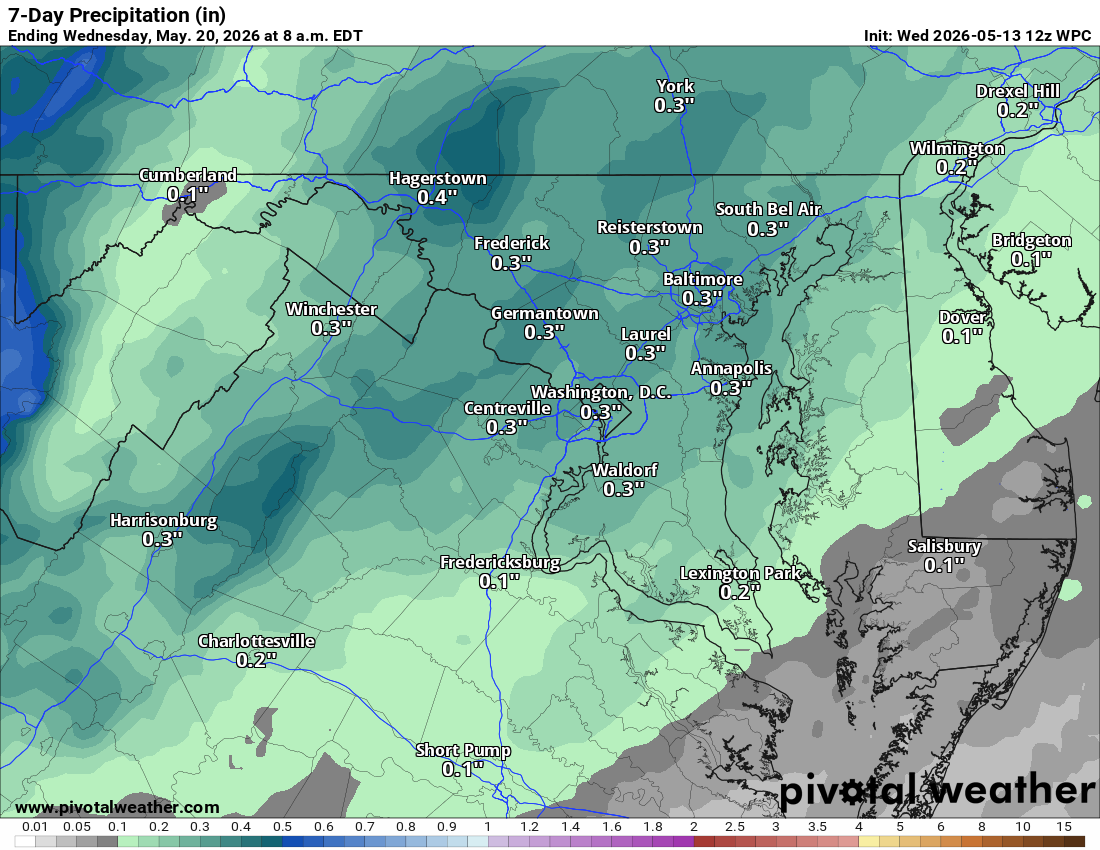
We have showers and thunderstorms heading into the area, especially this afternoon. According to models, we can expect the first batch mid-afternoon, followed by a break before another round arrives later this evening. A few of these could be on the stronger to severe side, so keep an eye on the sky.

🌤️ Cooler Friday, Warming Saturday
After today’s much-needed rain, tomorrow will feel much cooler with highs struggling to reach 64°F. We start our rebound on Saturday as temperatures climb back into the 70s under improving skies.

🔥 Major Heat Wave Incoming
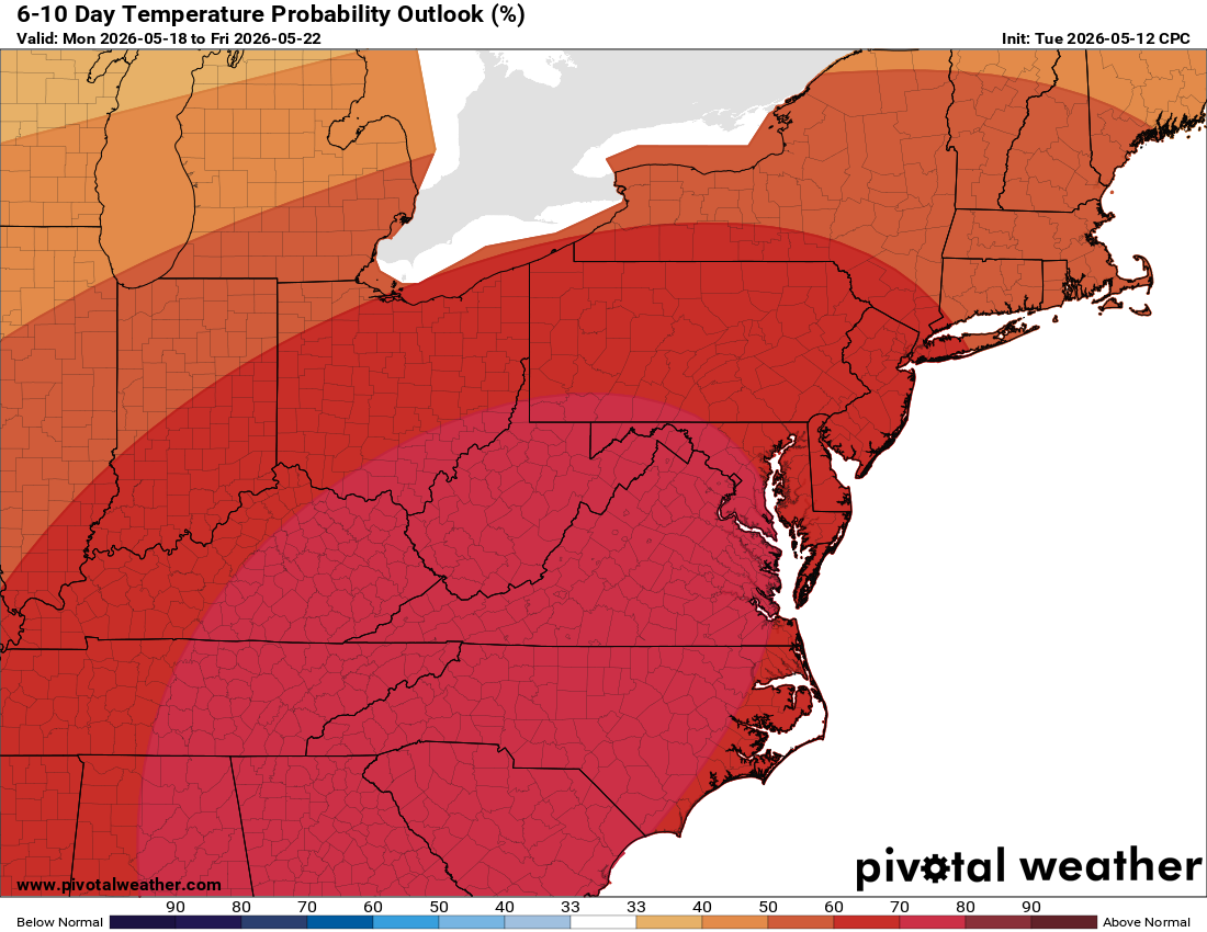
The big story is the heat arriving on Sunday. We’re looking at highs approaching 90°F or higher to end the weekend, with that heat wave sticking around through at least Monday and Tuesday. Nighttime lows will only drop into the 60s, so it won’t offer much relief.

Make sure those AC units are ready to go because we are heading into a prolonged hot stretch starting this Sunday!

The forecast:
Today: Hi 73 🌦️70% Lo 48 🌧️80% – Chance of showers and thunderstorms,
becoming showers likely with thunderstorms, then chance continues. Showers
and thunderstorms tonight before 1am, then a slight chance until 2am.

Thursday: Hi 63 ☁️ Lo 48 🌙 – Increasing clouds with northwest winds
gusting to 25 mph. Partly cloudy tonight.

Friday: Hi 72 ☀️ Lo 51 🌙 – Sunny with northwest winds gusting to 24 mph.
Partly cloudy tonight.

Saturday: Hi 84 🌤️ Lo 59 🌙 – Mostly sunny. Partly cloudy tonight.

Sunday: Hi 89 🌤️ Lo 63 🌙 – Mostly sunny. Mostly clear tonight.

Monday: Hi 92 ☀️ Lo 67 🌙 – Sunny. Mostly clear tonight.

Tuesday: Hi 93 🌞 – Mostly sunny.

#loudoun #loudouncountyva #vawx #loudounweather #loudounva #virginiaweather

Please support Tree of Life Ministries, an important organization to me!

Loudoun County Weather Outlook for Tuesday, May 12, 2026

Heat Wave in the Long Range! Beautiful day ahead!

🌞 **Gorgeous Tuesday Ahead!**
After a chilly start, today is a winner with crystal clear skies and highs near 70°F. Easily the best day of the work week!

🌦️ **Wednesday Storms**
Starting nice tomorrow, but showers and storms arrive late afternoon. Highs in the low 70s with rain ending overnight.

🌞 **Cool Thursday, Bright Friday**
Thursday cools down to the low 60s before we bounce back Friday with beautiful sun and low 70s.

🔥 **Major Heat Incoming**
Saturday hits the mid 80s, Sunday nears 90°F, and we jump into the 90s early next week. Humidity is tagging along.

🛠️ **Service Your AC**
Clean those filters and outdoor units now. You’ll need the AC running day and night by next week!

Have an awesome and beautiful Tuesday!
The forecast:
Today: Hi 70 ☀️ Lo 53 ⛅ – Sunny becoming partly cloudy

Wednesday: Hi 72 🌦️ 60% Lo 49 🌧️ 80% – Showers likely and possibly
thunderstorms, then showers and thunderstorms

Thursday: Hi 63 🌤️ Lo 48 ⛅ – Mostly sunny becoming partly cloudy

Friday: Hi 72 🌤️ Lo 52 ⛅ – Mostly sunny becoming partly cloudy

Saturday: Hi 84 🌤️ Lo 60 ⛅ – Mostly sunny becoming partly cloudy

Sunday: Hi 88 ☀️ Lo 62 ⛅ – Sunny becoming partly cloudy

Monday: Hi 91 🌤️ – Mostly sunny

#loudoun #loudouncountyva #vawx #loudounweather #loudounva #virginiaweather

Please support Tree of Life Ministries, an important organization to me!

image.png

image.png


Loudoun County Weather Outlook for Sunday, May 10, 2026

HAPPY MOTHER'S DAY

🌸 Mother's Day Warmth but Some Showers and Storms 🙁
Temps are up near 80°F, but we do have a pretty good chance of afternoon showers and thunderstorms, likely between 3:00 and 5:00 PM.

🌦️ Cooler Monday and Beautiful Tuesday
Tomorrow will be much cooler with highs only in the mid 60s. Tuesday looks beautiful with sunny skies and highs in the upper 60s.

⛈️ Midweek Rain Returns
We are back to near 70°F on Wednesday with a good chance of showers and thunderstorms, mainly in the afternoon and into the evening.

☀️ Sunny Finish to the Week
It looks beautiful for the end of the week. Temps near 70 Thursday, then expect sunny skies on Friday and low 80s on Saturday.

🌡️ Heating Up in the Extended
As we head into the extended outlook, temperatures should firmly stay above normal. We may even see highs approach the 90-degree mark.

The forecast:
Today: Hi 78 🌦️70% Lo 49 🌧️30% – Chance of showers and thunderstorms before
3pm, then showers likely and possibly a thunderstorm between 3pm and 4pm,
then a chance of showers and thunderstorms after 4pm. Tonight a chance of
showers and thunderstorms.

Monday: Hi 66 🌦️30% Lo 43 🌙 – Chance of showers mainly before 10am, then
cloudy gradually becoming mostly sunny. Mostly cloudy tonight then
gradually becoming mostly clear.

Tuesday: Hi 67 ☀️ Lo 49 ⛅ – Sunny with partly cloudy skies tonight.

Wednesday: Hi 70 🌧️70% Lo 50 🌧️70% – Showers likely mainly after 2pm.
Showers likely before 2am tonight.

Thursday: Hi 67 🌤️ Lo 49 🌙 – Mostly sunny with mostly clear skies tonight.

Friday: Hi 73 🌤️ Lo 53 ⛅ – Mostly sunny with partly cloudy skies tonight.

Saturday: Hi 81 🌤️ – Mostly sunny.

#loudoun #loudouncountyva #vawx #loudounweather #loudounva #virginiaweather

Please support Tree of Life Ministries, an important organization to me!

Loudoun County Weather Outlook for Saturday, May 9, 2026

🌤️ Good Saturday to Ya!
Most of today stays dry, but we do have about a 40% chance for a few showers and maybe a rumble of thunder. A couple of spotty showers are possible this morning, but the better chance arrives after 2 PM this afternoon.

🌦️ Warm Mother’s Day Ahead
Sunday turns warmer with highs pushing near 80°. Most of the day looks fine, but scattered showers and thunderstorms could develop late afternoon and evening, mainly after 4 PM. Rain chances increase Sunday night

🌧️ Unsettled Middle of the Week
Monday cools back into the 60s, with mid-60s Tuesday and upper 60s to near 70 on Wednesday. More showers return Wednesday into Thursday.

☀️ Watching a Warmer Pattern
Next weekend may trend drier, but looking farther ahead, signs point to a stretch of summery heat developing the following week.

🌱 Drought Concerns Continue
With drought conditions already stressing vegetation, a hot pattern developing later in May could quickly increase stress on plants and lawns

The forecast:
Today: Hi 71 🌦️40% Lo 51 🌙 – Isolated showers, then scattered showers and
thunderstorms after 2pm.

Sunday: Hi 79 ⛅30% Lo 49 🌧️70% – A chance of showers and thunderstorms,
mainly after 4pm.

Monday: Hi 63 🌧️60% Lo 42 🌙 – Showers likely, mainly before 8am.

Tuesday: Hi 64 ☀️ Lo 46 ⛅ – Sunny.

Wednesday: Hi 67 🌧️70% Lo 50 🌧️70% – Showers likely.

Thursday: Hi 68 🌦️40% Lo 49 🌧️ 30% – A chance of showers. Partly sunny.

Friday: Hi 71 🌞 – Mostly sunny.

#loudoun #loudouncountyva #vawx #loudounweather #loudounva #virginiaweather

Please support Tree of Life Ministries, an important organization to me!

Next weekend may trend drier, but looking farther ahead, signs point to a stretch of summery heat developing the following week.additional chances of helpful rainfall.nce arrives after 2 PM this afternoon.on.

image.png

image.png

Loudoun County Weather Outlook for Friday, May 8, 2026 Happy Friday! 🌤️ A nice spring day is ahead with highs near 70 degrees this afternoon. 🌦️ Mostly Dry Weekend Ahead Saturday continues to look mainly dry. A stray shower or thunderstorm can’t be ruled out later in the day or during the evening. 🌸 Nice Mother’s Day Ahead Sunday is shaping up to be a beautiful Mother’s Day with highs reaching the upper 70s. Most of the day looks dry with just a slight chance of a late afternoon or evening shower or thunderstorm. 🌧️ Better Rain Chances Sunday Night Monday stays on the cool side, with highs in the low 60s and scattered showers. Temperatures recover into the mid-60s on Tuesday before more shower chances return by the middle of next week. 🌡️ Cooler Early Next Week Monday stays on the cool side with highs in the low 60s and scattered showers around. Temperatures recover into the mid-60s on Tuesday. Toward the end of next week, we should begin drying ou

Happy Friday! 🌤️
A nice spring day is ahead with highs near 70 degrees this afternoon.

🌦️ Mostly Dry Weekend Ahead
Saturday continues to look mainly dry. A stray shower or thunderstorm can’t be ruled out later in the day or during the evening.

🌸 Nice Mother’s Day Ahead
Sunday is shaping up to be a beautiful Mother’s Day with highs reaching the upper 70s. Most of the day looks dry with just a slight chance of a late afternoon or evening shower or thunderstorm.

🌧️ Better Rain Chances Sunday Night
Monday stays on the cool side, with highs in the low 60s and scattered showers. Temperatures recover into the mid-60s on Tuesday before more shower chances return by the middle of next week.

🌡️ Cooler Early Next Week
Monday stays on the cool side with highs in the low 60s and scattered showers around. Temperatures recover into the mid-60s on Tuesday.

Toward the end of next week, we should begin drying out again with temperatures edging back toward 70 degrees.

The Forecast:
Today: Hi 69 ☀️ Lo 49 🌙 – Sunny becoming partly cloudy tonight

Saturday: Hi 71 🌦️40% Lo 51 🌙 – Slight chance of showers, then chance of
showers and thunderstorms after 2pm, becoming clear tonight

Sunday: Hi 77 🌦️20% Lo 49 🌧️80% – Mostly sunny with slight chance of
showers and thunderstorms, then showers and thunderstorms likely tonight

Monday: Hi 61 🌧️80% Lo 42 🌙 – Showers mainly before 8am, then partly
cloudy tonight

Tuesday: Hi 64 ☀️ Lo 46 ⛅ – Sunny becoming partly cloudy tonight

Wednesday: Hi 66 🌧️70% Lo 48 🌧️60% – Showers likely

Thursday: Hi 67 ⛅ – Partly sunny

#loudoun #loudouncountyva #vawx #loudounweather #loudounva #virginiaweather

Please support Tree of Life Ministries, an important organization to me!

A nice spring day is ahead with highs near 70 degrees this afternoon. It’ll turn a bit breezy at times, but overall, we’re looking at great weather to get outside and enjoy.

image.png

image.png