12/13/2021 – It is going to be a mild week. A chance of showers Friday night and Saturday. We will then turn cooler. I am still interested in the possibility of something Christmas week, but just not sure. The Long-range shows above-normal temperatures, but I am not completely convinced we stay all above normal.
Anyways! Great week to get a few outdoor chores handled if you need to!
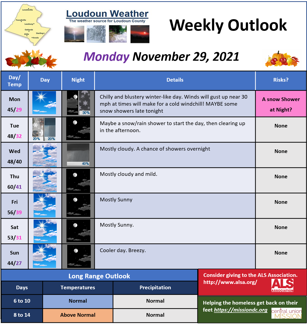
Cool and breezy day. Maybe some snow showers late tonight or early tomorrow. Continued cool tomorrow and Wednesday, with some showers Wednesday night related to a warm front that will make it a very Mild Thursday. The forecast after Thursday is a bit questionable based on what side of a front we are on. For now, I have it staying mild Friday and Saturday and then cooler Sunday. That is subject to change for sure. The long-range looks like it will ultimately warm-up, but the long-range is a bit of a challenge! Have a great Monday!
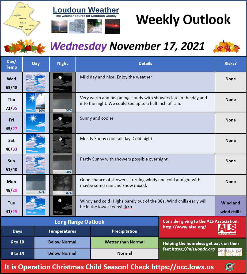
Mild weather today and tomorrow. Much cooler Friday into Saturday. Some showers Monday that may mix with some snow showers Monday night. The long-range continues to look colder than normal and I am watching for late next week into the weekend for potentially some wintry weather. Way too far off to get too excited. If you have not winterized the hose bibs and hoses, now is the time!
The Mid-Atlantic has a lot of factors because of the proximity to the Atlantic Ocean, Mountains, and even the Great Lakes. I want to outline the impacts of these AND the Pacific which will all impact this winter, especially early in the year!
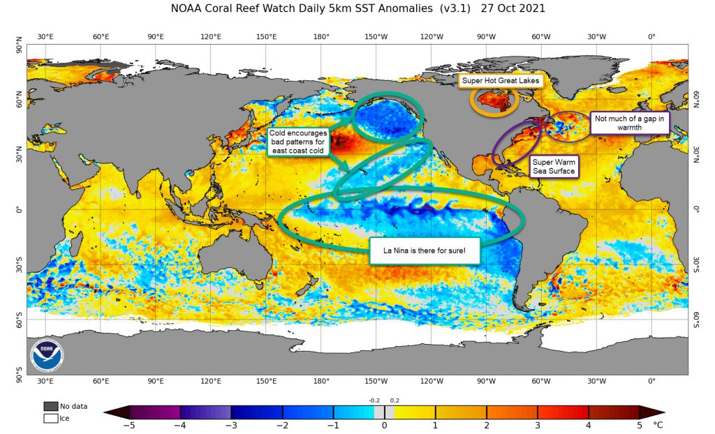
Atlantic Temps are WAY WARM!
The Atlantic Ocean is currently much warmer than normal. I think this will impact us in several ways:
Storm systems will have a lot more moisture to work with! The heat should evaporate more moisture and juice up any storm system. This is part of why I think each time the forecast models say it will be a dry period, they back off pretty quickly
The Western Atlantic Ridge (which at times is known as the Bermuda High) will be strengthened by the warmer air. This could slow the infiltration of colder air and stall fronts away from the coast and make them just inland. This could have a significant effect on the rain/snow line!
Warmer temps from the ocean will also make marginal (close to frozen events) more likely to be a mix or even rain. That heat will make it inland! This becomes less of a factor for the western zones, but does impact the upper levels which could make sleet and freezing rain a problem. This is not new, but could be a more common set up
The Greenland Temperature Gap
There is often a cold pool off the Northeastern United States that is linked, many times, to a better negative NAO (See previous posts for information on the NAO)
Great Lakes
You would not think the Great Lakes would have too much impact on our weather, but it really does! The Great Lakes can provide additional moisture to some storm systems, and, if it is warm, it can help moderate temps that are being impacted by winds that go across them. I am not saying this is a huge factor, but it does have an impact.
The Pacific Looks Poor
Probably one of the worst looks I have seen in a long while. The colder weather will encourage cold storms and the Jet Stream to be in a poor setup for us. I will discuss the Pacific Decadal Oscillation, the Pacific North American weather patterns, and the Eastern Pacific Oscillation in a post soon. All I can say is the pattern will favor milder terms for us and drier than normal conditions. I just do not like it.
Of course, we also have La Nina which will not bode well for big storms.
Summary
Most of the ocean looks terrible for us for winter. It is also the biggest signal that the winter may be warmer than normal and have less snow.
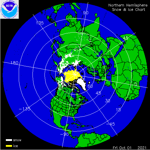
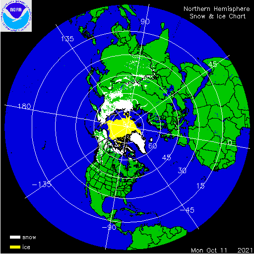
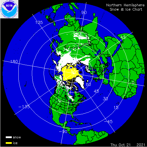
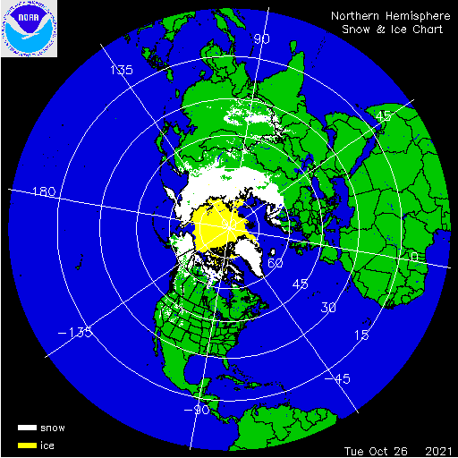
The Snow Advance Index is a feature that is not always the best indicator for how our winter will be. The basic principle is that the advancement of snow cover in October is closely linked to the phase of the North Atlantic Oscillation.
North Atlantic Oscillation
The North Atlantic Oscillation (NAO) measurement is a KEY FEATURE needed to help get snowstorms on the East Coast of the United States. For example, the NAO is currently negative, which helps to slow down and aid in the development of big Nor’easters like the one we are having this week (October 26 – 27, 2021)
Really, though, the negative NAO (NAO-) is not the key to these storms, it is as the NAO flips back and forth between the negative and positive (NAO+) that usually signals a storm
Anyways, when the Snow Advance Index shows a great increase, the NAO *COULD* end up being more negative for the winter.
So what is the Snow Advanced Index Looking Like?
Snow Progression
The index is actually below where I would like to see it, but it is higher than last year!
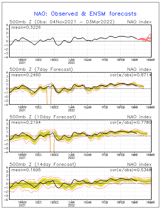
The NAO Has been running Negative for a long while now. We will see if this can continue into November and Beyond! That would be a good sign for offsetting the La Nina impacts. (The line is below the 0)
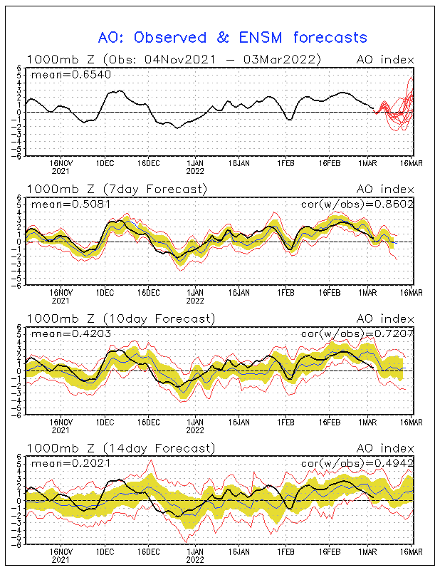
Another factor for colder conditions is the Arctic Oscillation! As noted yesterday, when the Polar Vortex gets disrupted, it can turn negative! WE NEED THE NEGATIVE (if you like snow)! That is a better indication for more snow in the east! It has been running back and forth between positive and negative phases. We will see how this works out, but it looks like it is heading to negative again so the colder long-range seems to be linked to this as well! (Observed in black and red the various model predictions)
I am not super convinced we get non-stop help from the Arctic Oscillation this year, but I do expect a lot of variabilities which could help us at times be colder and have a chance of winter weather.
In Summary
I do not think we have much to count on from the Snow Advanced Index, North Atlantic Oscillation, or Arctic Oscillation. The negative NAO has been encouraging, but that alone will not set us right for winter weather.