Local weather. A little perspective.Loudoun County, VirginiaOfficial NWS alerts ↗
Loudoun County, Virginia

Category: Uncategorized

Loudoun County Weather Outlook for Sunday, February 1, 2026

2/1/2026
❄️ Bitter Cold Holds On – Some Snow Chances Ahead
It is frigid out there today with highs only in the low 20s and wind chills making it feel below zero.

🌡️ Slow Warm-Up this week
Tomorrow stays cold, but temps may briefly climb above freezing, leading to some melting and ponding overnight. On Tuesday and Wednesday, we could see temps in the mid- to even upper 30s! Colder Thursday and Friday with highs near freezing.

🌨️ Minor Snow Chances Wednesday Night & Friday
We could see light snow on Wednesday evening into the overnight, and again on Friday with a frontal passage. Neither system looks like a big deal.

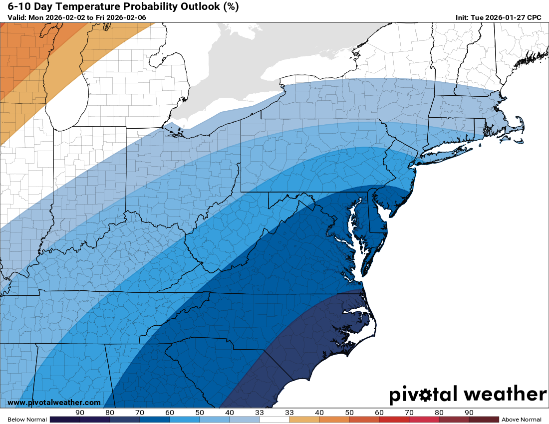
💨 Arctic Air Returns Next Weekend
A strong front Friday night will usher in very cold air again Saturday with gusty winds. Bundle up for a frigid start to next weekend.

This dry pattern sticks around, and drought concerns remain, but stay weather-aware with those few snow chances ahead. There are hints that after the next cold shot, we may see a brief warming around Valentine's Day, but that may also bring snow chances!

The forecast:
Today: Hi 23 🌤️ Lo 12 🌙 – Mostly sunny and blustery, becoming mostly clear and breezy overnight

Monday: Hi 32 ☀️ Lo 15 ☁️ – Sunny and cold with lighter wind, becoming partly cloudy overnight

Tuesday: Hi 38 ⛅ Lo 23 🌧️❄️30% – Partly sunny with increasing clouds and a chance of late-night snow

Wednesday: Hi 31 ⛅ Lo 13 🌙 – Partly sunny and colder, then clear and chilly overnight

Thursday: Hi 30 ☀️ Lo 14 ☁️ – Sunny and seasonably cold, becoming partly cloudy

Friday: Hi 36 ⛅❄️30% Lo 14 ☁️ – Mostly cloudy with a slight chance of snow, remaining cloudy overnight

Saturday: Hi 23 🌤️ Lo 10 🌙 – Mostly sunny and blustery, with a clear and very cold night

#loudoun #loudouncountyva #vawx #loudounweather #loudounva #virginiaweather

Please support Tree of Life Ministries, an important organization to me! https://www.tolministries.org


image.png
image.png

Loudoun County Weather Outlook for Saturday, January 31, 2026

1/31/2026 – Cold but some warming next week. Some snow is possible next week. Even colder temps possible the following week!

❄️ Bitter Cold Weekend Ahead
Highs today will barely reach 20°F, and light breezes will turn into very strong winds tonight. Wind chills overnight into Sunday morning could plummet to -11°F!

🌬️ Frigid and Windy Sunday
Tomorrow will be brutally cold, with highs only in the mid-20s. Winds will be harsh, making it a tough day to be outdoors. The wind sticks around into Monday, but temps rebound to the low 30s.

🌨️ Chilly Week With Snow Chances
From Monday to Wednesday, expect highs in the low to mid-30s. Some light snow is possible late Wednesday night, but totals are still uncertain. Cold continues Thursday and Friday, with highs in the 30s and another snow chance Friday into Friday night.

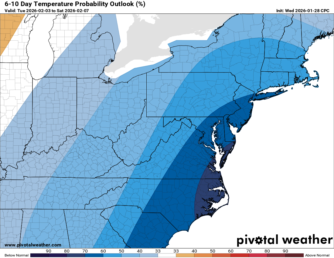
🥶 Colder Air Possible Next Week
Long-range models hint at an even colder shot early the following week. Stay warm and stay tuned.

Today: Hi 19 ⛅ Lo 8 ☁️ – Partly sunny and breezy, becoming mostly cloudy and blustery overnight

Sunday: Hi 25 ☀️ Lo 13 🌙 – Mostly sunny and very windy, becoming mostly clear and cold

Monday: Hi 33 ☀️ Lo 14 🌙 – Sunny and breezy, then partly cloudy overnight

Tuesday: Hi 37 ⛅ Lo 23 ☁️❄️30% – Partly sunny, with a chance of snow late overnight

Wednesday: Hi 31 ⛅ Lo 14 🌙 – Partly sunny and cold, becoming partly cloudy

Thursday: Hi 31 🌤️ Lo 14 🌙 – Mostly sunny and breezy, with a cold night

Friday: Hi 35 ⛅❄️30% Lo 25 ❄️30% – Partly sunny with a chance of snow, continuing into the night

#loudoun #loudouncountyva #vawx #loudounweather #loudounva #virginiaweather

Please support Tree of Life Ministries, an important organization to me! https://www.tolministries.org


image.png
image.png

Loudoun County Weather Outlook for Friday, January 30, 2026

1/30/2026 – Cold weather advisory! Slightly warmer next week!
🌬️ Cold Today, Even Colder Saturday
Highs today will reach near 20°F with Saturday even colder and stuck in the teens. A cold weather advisory remains in effect tonight as lows dip into the single digits.

💨 Blustery Winds This Weekend
Winds will really pick up Saturday night into Sunday as a strong coastal storm develops near the Outer Banks. Expect very gusty conditions with blizzard warnings possible to our south.

🥶 Arctic Air Holds On but Some Relief Ahead
Sunday warms slightly into the mid 20s. Monday and Tuesday bring highs near and finally above freezing.

❄️ Snow Chance Wednesday
There’s a chance of snow Wednesday into Wednesday night, though the storm may track south of us. Something to keep an eye on over the next few days.

🌡️ Not as Cold Next Week
Next week should feel a bit more tolerable with milder air trying to push in. However, signs are pointing to a potentially serious cold outbreak developing the following week. Stay tuned.

The forecast:
Today: Hi 20 🌤️ Lo 4 ☁️ – Mostly sunny, becoming mostly cloudy overnight

Saturday: Hi 19 ⛅ Lo 8 ☁️ – Partly sunny and breezy, with increasing clouds at night

Sunday: Hi 24 ☀️ Lo 13 🌙 – Sunny and blustery, clear and cold overnight

Monday: Hi 32 ☀️ Lo 15 🌙 – Sunny with a cold, clear night

Tuesday: Hi 35 🌤️ Lo 20 ☁️ – Mostly sunny, becoming mostly cloudy overnight

Wednesday: Hi 33 ❄️40% Lo 22 ❄️40% – Mostly cloudy with a chance of snow during the day and night

Thursday: Hi 33 🌤️ Lo 20 🌙 – Mostly sunny and cold with a clear night

#loudoun #loudouncountyva #vawx #loudounweather #loudounva #virginiaweather

Please support Tree of Life Ministries, an important organization to me! https://www.tolministries.org


image.png

Loudoun County Weather Outlook for Thursday, January 29, 2026

1/29/2026
🌬️ Cold Blast Continues
Bundle up! Highs today only reach the low 20s with wind chills making it feel even colder. Another frigid night ahead with lows dropping into the single digits and wind chills below zero prompting a cold weather advisory.

❄️ Brutal Cold Holds Through Saturday
Friday’s high will hover around 20, and Saturday looks even colder with highs stuck in the teens. Not much change in the pattern through the weekend.

🌥️ Watching the South, But Staying Dry
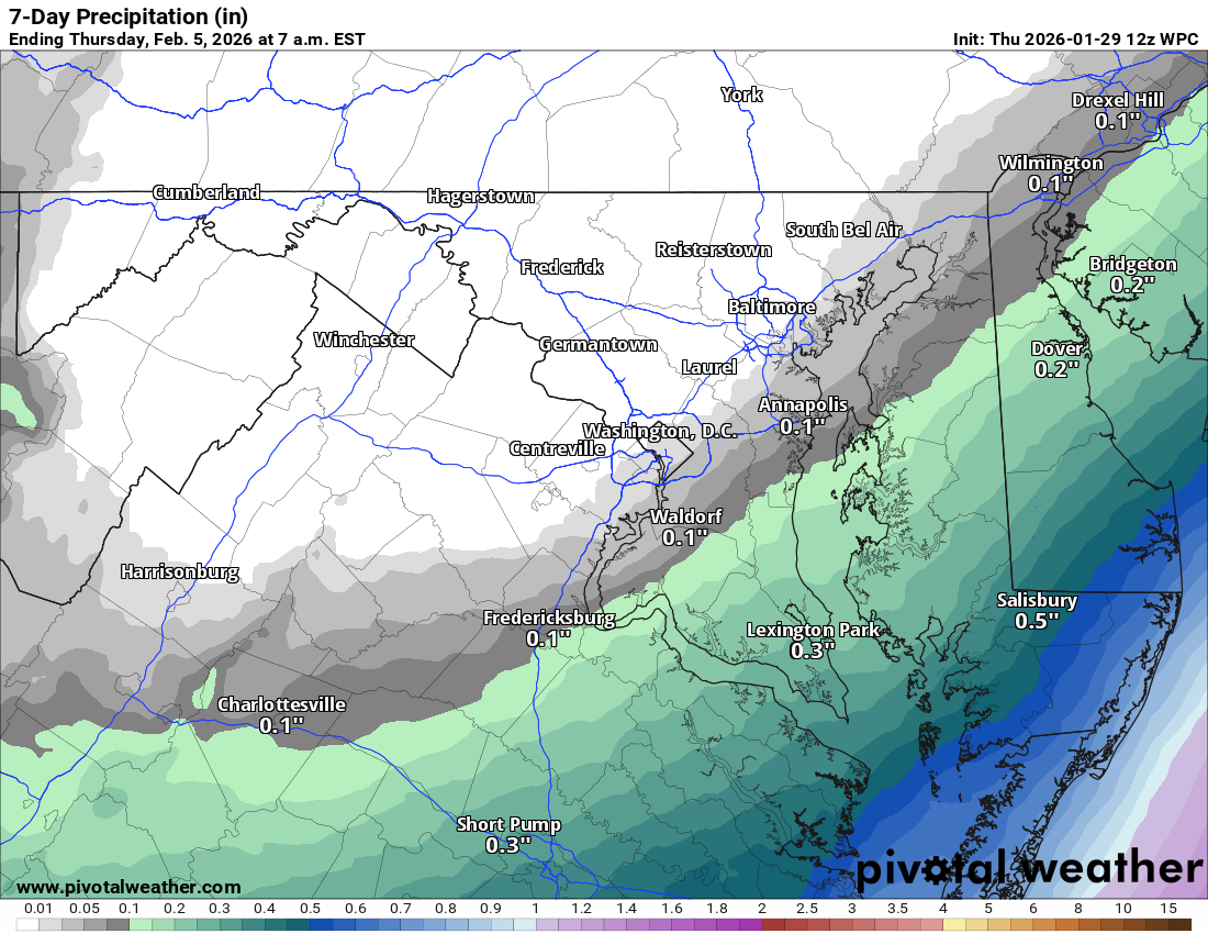
The winter storm we have been tracking will stay to our south and could bring big snow to the Outer Banks and parts of coastal North Carolina and South Carolina. Virginia looks to dodge the snow, except maybe far south and southeast areas into Delmarva.

🌡️ Gradual Warm-Up Next Week
Sunday edges back into the 20s, and we could flirt with 32 by Monday. By midweek, highs may climb into the low to mid-30s.

🌨️ Eyes on Late Week
We’re keeping an eye on potential activity later next week. Too early for details, but I will be watching closely.

The forecast:
Today: Hi 21 🌤️ Lo 3 🌙 – Mostly sunny and cold, becoming partly cloudy overnight

Friday: Hi 20 🌤️ Lo 6 ☁️ – Mostly sunny and chilly, becoming mostly cloudy overnight

Saturday: Hi 18 ☁️20% Lo 8 ❄️20% – Mostly cloudy with a slight chance of afternoon snow, continuing overnight

Sunday: Hi 23 ⛅ Lo 13 🌙 – Partly sunny and blustery, clearing at night

Monday: Hi 32 ☀️ Lo 15 🌙 – Sunny and cold, mostly clear overnight

Tuesday: Hi 35 🌤️ Lo 19 🌙 – Mostly sunny, becoming partly cloudy overnight

Wednesday: Hi 33 ⛅ Lo 21 ☁️ – Partly sunny, with increasing clouds overnight

#loudoun #loudouncountyva #vawx #loudounweather #loudounva #virginiaweather

Please support Tree of Life Ministries, an important organization to me! https://www.tolministries.org


image.png
image.png

Loudoun County Weather Outlook for Wednesday, January 28, 2026

1/28/2026 – Watching the weekend, but snow is less likely! Will update early afternoon!
❄️ Chilly Day with a Surprise Snow Chance
Highs around 20 today with a 20 to 30 percent chance of snow late this afternoon into early evening. The best chance is in eastern Loudoun, especially near rush hour.

🌙 Bitter Cold Tonight
Lows drop into the single digits. Highs stay

image.png

around 20 on Thursday and Friday.

🌨️ Watching the Weekend
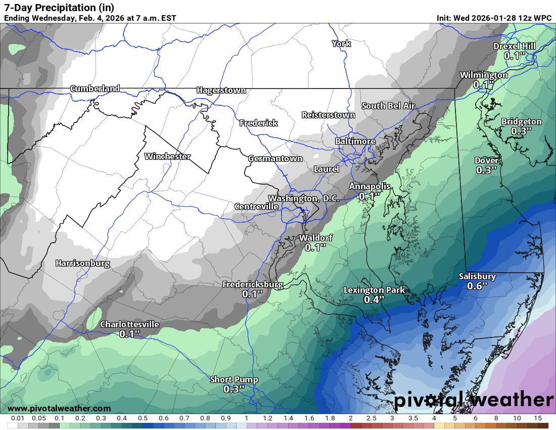
Highs only in the teens on Saturday. Some snow is possible Saturday night into Sunday. Sunday will be cold and windy as a storm moves off to our east.

🌡️ Slight Warmup Next Week
Highs climb into the 30s on Monday and could push above freezing by Tuesday. That will end a very long stretch of below-freezing weather!

📅 Typical Snow Window
This is the usual stretch for snow. While the trend looks colder and drier, a system could pop up as we head into later next week.

The forecast:
Today: Hi 21 ⛅ Lo 4 🌙 – Increasing clouds during the day, becoming partly cloudy overnight

Thursday: Hi 22 ☀️ Lo 5 🌙 – Mostly sunny during the day, mostly clear at night

Friday: Hi 20 ☀️ Lo 5 ☁️ – Mostly sunny, turning mostly cloudy overnight

Saturday: Hi 17 ⛅ Lo 10 ☁️ – Partly sunny and cold, mostly cloudy and blustery overnight

Sunday: Hi 23 ⛅ Lo 13 🌙 – Partly sunny and breezy, partly cloudy and blustery overnight

Monday: Hi 31 ☀️ Lo 13 🌙 – Mostly sunny during the day, partly cloudy overnight

Tuesday: Hi 33 ☀️ Lo 20 🌙 – Mostly sunny with a clear and cold night

#loudoun #loudouncountyva #vawx #loudounweather #loudounva #virginiaweather

Please support Tree of Life Ministries, an important organization to me! https://www.tolministries.org


image.png

image.png