Local weather. A little perspective.Loudoun County, VirginiaOfficial NWS alerts ↗
Loudoun County, Virginia

Category: Uncategorized

Loudoun County Weather Outlook for Friday, March 6, 2026

3/6/2026
☁️ Cloudy And Cool Today
Expect a gray Friday with highs only reaching 54°F. A stray shower is possible, but most will stay dry with just a 20% chance of rain.

🌤️ Warmer Weekend Ahead
Temperatures start to climb tomorrow with highs in the low 70s. We'll keep a slight chance of showers in the mix for Saturday and Sunday, though plenty of dry time is expected.

☀️ Gorgeous Start To The Week
Monday and Tuesday look spectacular. Highs will hover in the low to mid 70s under clear, sunny skies.

🌦️ Turning Cooler Late Week
We'll hit the upper 70s by Wednesday before rain chances return. A sharp reality check arrives Thursday as temperatures tumble back into the mid 50s.

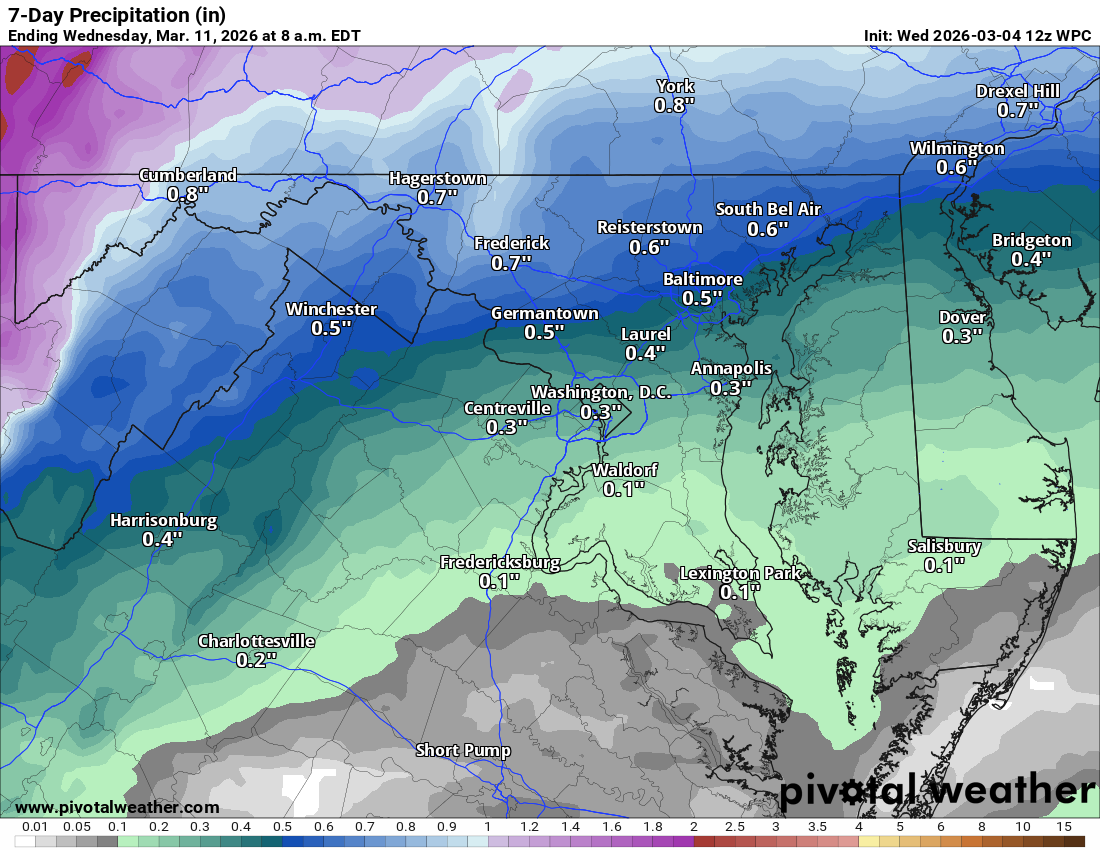
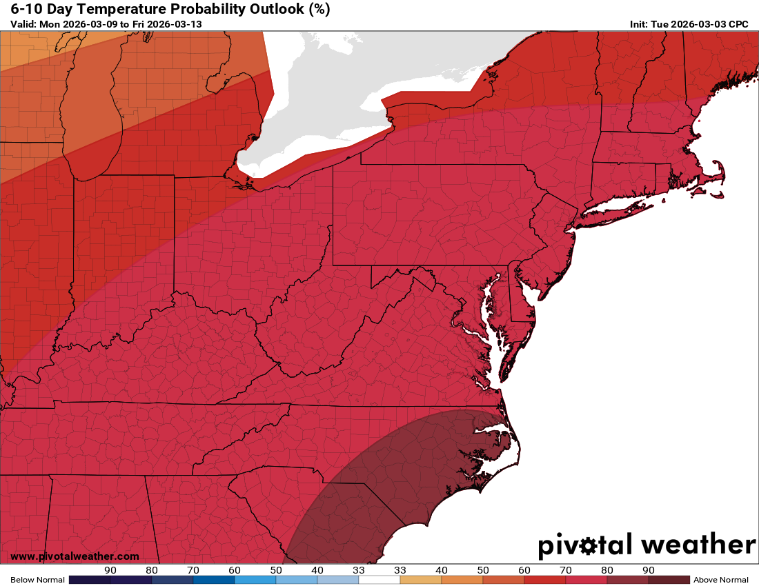
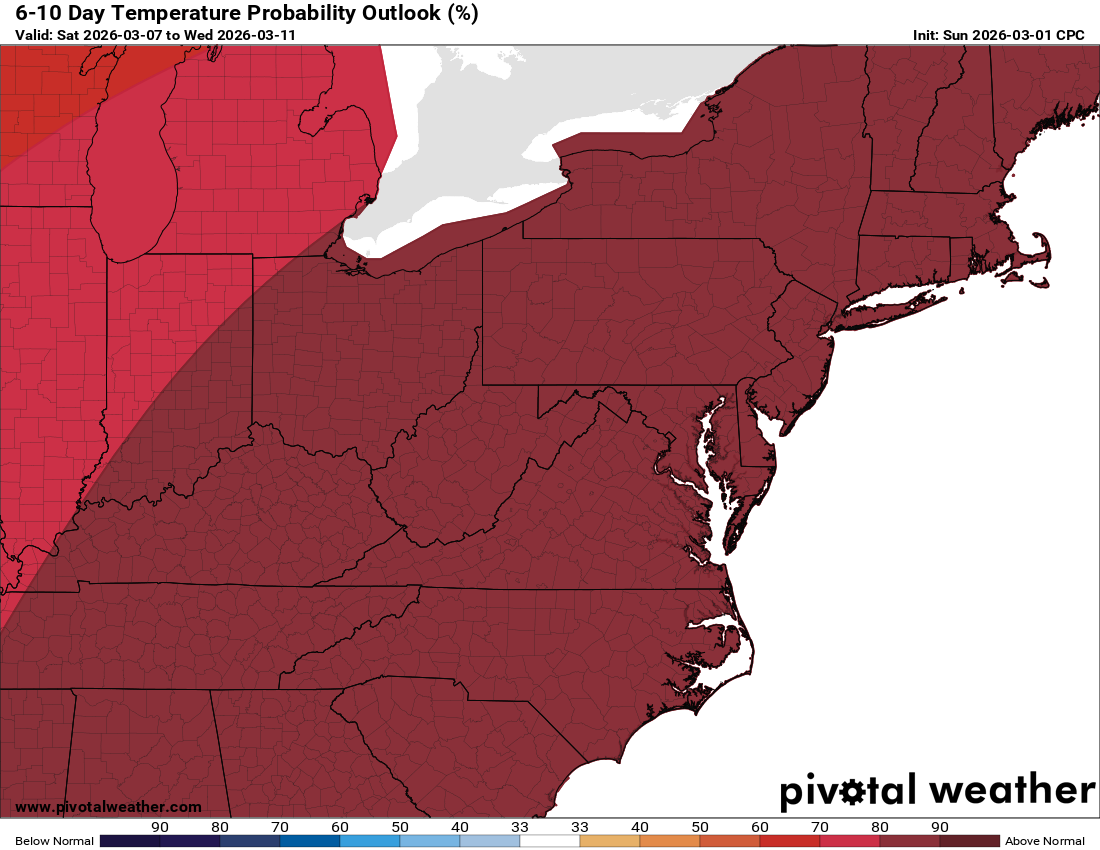
The very long-range shows temperatures going back below normal for a bit. Could winter give us a bit of a closing act? I am not certain, but not ruling it completely out!

The forecast:
Today: Hi 55 🌦️40% Lo 45 🌧️30% – Mostly cloudy with a chance of showers and areas of fog throughout the day and evening

Saturday: Hi 73 🌦️50% Lo 60 🌧️60% – Patchy morning fog followed by a chance of showers, with rain becoming likely overnight

Sunday: Hi 69 🌦️30% Lo 47 🌙 – Partly sunny with a chance of showers, clearing by evening

Monday: Hi 72 🌞 Lo 53 🌙 – Mostly sunny and clear

Tuesday: Hi 76 🌞 Lo 57 🌙 – Mostly sunny and clear

Wednesday: Hi 75 🌦️50% Lo 48 🌧️60% – Partly sunny with a chance of showers, with rain becoming likely overnight

Thursday: Hi 56 🌦️30% Lo 45 🌧️ – Mostly cloudy with a chance of showers
#loudoun #loudouncountyva #vawx #loudounweather #loudounva #virginiaweather

Please support Tree of Life Ministries, an important organization to me! https://www.tolministries.org


image.png
image.png

Loudoun County Weather Outlook for Thursday, March 5, 2026

3/5/2026
🌫️ Foggy Start, Stormy Finish
We had some dense fog last night because the ground remains pretty cold. Fog should break up later this morning. This evening, we could see some showers and thunderstorms as we hit the mid-60s.

📉 Backdoor Front Tomorrow
Tomorrow, a backdoor front is lowering the temperature outlook. This time of year, backdoor fronts off the ocean are always a possibility, and they are notoriously hard for models to catch. Currently, highs are in the mid to upper 50s, but we could see them even colder!

📈 Weekend Rebound
Things should reverse on Saturday as we shoot up into the 70s. We will settle into the 60s for Sunday, and then we get back to the 70s for Monday through Wednesday. We could even see temperatures hit 80°F next Wednesday!

🌦️ Unsettled Pattern
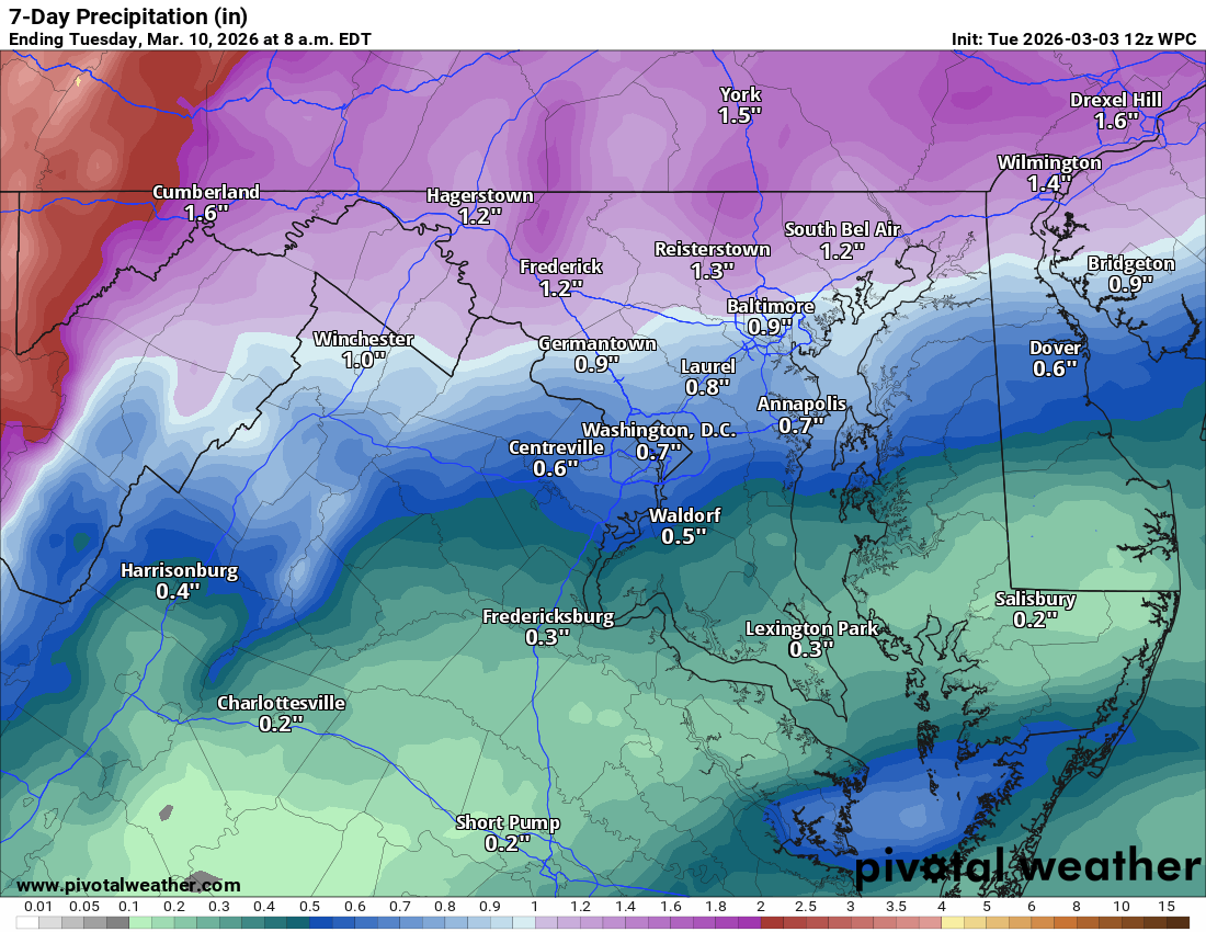
We have daily chances of showers because the front separating warm and cold air is close to us. That always brings some concern that the boundary could dip south of us (like tomorrow). The best chances of rain appear to be this evening and Saturday night; otherwise, things are scattered every day. The long-range still looks above normal for temperatures and much-needed rainfall.

The forecast:
Today: Hi 63 🌦️⛈️40% Lo 48 🌧️70% – Mostly cloudy with isolated morning showers and afternoon thunderstorms, followed by showers and storms likely before 2am

Friday: Hi 56 🌦️30% Lo 46 🌧️20% – Partly sunny with scattered showers

Saturday: Hi 74 🌦️40% Lo 57 🌧️60% – Mostly cloudy with a chance of showers after 1pm, then showers likely through the night

Sunday: Hi 67 ☁️ Lo 47 🌙 – Mostly cloudy

Monday: Hi 70 🌞 Lo 51 🌙 – Mostly sunny and clear

Tuesday: Hi 76 🌞 Lo 59 🌙 – Mostly sunny and partly cloudy

Wednesday: Hi 78 🌦️40% Lo 58 🌧️40% – Mostly cloudy with a chance of showers

#loudoun #loudouncountyva #vawx #loudounweather #loudounva #virginiaweather

Please support Tree of Life Ministries, an important organization to me! https://www.tolministries.org


image.png
image.png

Loudoun County Weather Outlook for Wednesday, March 4, 2026

3/4/2026
🌤️ Mild & Damp Wednesday
Highs today reach around 50°F. We’ll see some breaks of sun, but don’t get too comfortable as more rain moves back in later today and continues into tomorrow.

🌧️ Warming Up with Storm Potential
Highs climb into the low to mid 60s for Thursday and we have chances for showers and even some thunderstorms

🌤️ Friday Refinement
Friday looks really nice overall with a high near 63°F. While original forecasts teased the 70s, a bit of cooler air from a northern front is nudging those numbers down slightly.

🌡️ A Run for 80?
Saturday brings a significant warmup with many areas seeing 70s and a real chance for some spots in the county to hit 80°F! There is a chance of showers. Sunday remains mild with highs around 70°F and continued shower chances.

🐸 Spring is Calling
The spring pattern really takes hold early next week. Monday and Tuesday look beautiful with highs in the 70s and another run toward 80°F by Tuesday.

The forecast:
Today: Hi 49 🌦️80% Lo 45 🌧️80% – Showers and patchy fog

Thursday: Hi 64 🌦️60% Lo 51 🌧️60% – Areas of fog early with showers likely, including a possible thunderstorms

Friday: Hi 63 🌦️30% Lo 51 ☁️ – Partly sunny with a chance of afternoon showers

Saturday: Hi 77 🌦️50% Lo 54 🌧️40% – Partly sunny with a chance of afternoon showers

Sunday: Hi 68 🌦️30% Lo 49 ☁️ – Partly sunny with a chance of showers

Monday: Hi 71 ⛅ Lo 53 🌙 – Partly sunny during the day and becoming partly cloudy at night

Tuesday: Hi 78 🌞 Lo 56 🌙 – Mostly sunny and warm

#loudoun #loudouncountyva #vawx #loudounweather #loudounva #virginiaweather

Please support Tree of Life Ministries, an important organization to me! https://www.tolministries.org


image.png
image.png

Loudoun County Weather Outlook for Tuesday, March 3, 2026

c3/3/2026
⏰ Wintertime is coming to an end!
That was likely winter's last hurrah. Yesterday, some folks reported between 2 and 3 inches of snow, and I definitely had over 2 inches on the deck here in Purcellville. We had a lot of freezing rain overnight, but fortunately roads are mostly clear. Things should warm up today. True winter should now be done, though might get a cold day here or there; a sustained winter pattern is over.

🌧️ Rain Chances Continue
Rain remains in the forecast today as we stay unsettled with a front nearby. Highs will struggle to reach 45°F today before we start to see a gradual warming trend.

🌦️ Unsettled Week Ahead
We have a chance for showers every single day this week, except maybe Friday! Being so close to the front means the models are struggling; we could see 70s one day and 50s the next if the cold air nudges in. Models will struggle to see this, so do not be surprised by a quick change.

🌡️ Milder Pattern Building
We should hit 70s Friday, and that should last into next week (barring a surprise backdoor front messes things up!)

The Forecast:
Today: Hi 43 🌧️80% Lo 42 🌧️90% – Rain throughout the day with patchy fog, continuing into the night

Wednesday: Hi 57 🌧️60% Lo 48 🌧️70% – Rain likely, mainly in the afternoon

Thursday: Hi 69 🌦️⛈️50% Lo 54 🌧️60% – Mostly cloudy with a chance of showers and afternoon thunderstorms continuing overnight

Friday: Hi 73 🌞 Lo 51 ☁️ – Mostly sunny and pleasant

Saturday: Hi 74 🌦️30% Lo 57 🌧️50% – Partly sunny with a chance of afternoon showers

Sunday: Hi 72 🌦️40% Lo 54 🌧️30% – Mostly cloudy with a chance of showers

Monday: Hi 73 🌦️30% Lo 55 🌧️30% – Partly sunny with a chance of showers

#loudoun #loudouncountyva #vawx #loudounweather #loudounva #virginiaweather

Please support Tree of Life Ministries, an important organization to me! https://www.tolministries.org

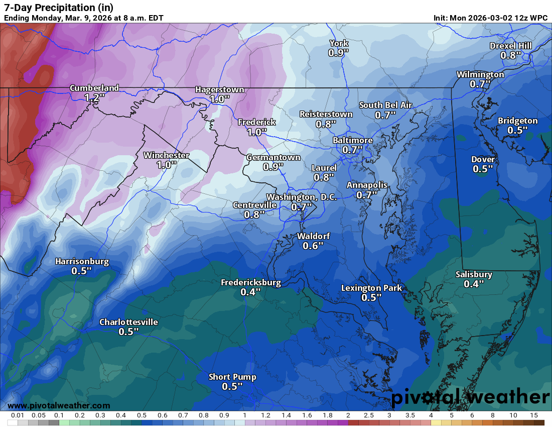
Loudoun County Weather Outlook for Monday, March 2, 2026

3/2/2026 – ⚠️Winter Weather Advisory overnight for some icing ⚠️
❄️ Midday Snow Burst
It is going to be a cloudy and cold day with some snow breaking out somewhere around midday. It could be briefly heavy, and whiten some roadways, but most likely it will just accumulate on grass areas, but up to an inch is possible if we get into a small area of enhanced snow.

🧊 Icy Mix Tonight
Tonight, temperatures will fall into the upper 20s as more snow arrives. The snow should change over pretty quickly to sleet, then to freezing rain by late tonight. We have a Winter Weather Advisory from 10 p.m. until 10 a.m. tomorrow.

🌧️ Transition to Rain
By tomorrow afternoon, things will just turn over to plain rain.

🌡️Warming Up
Temperatures will be in the 60s on Wednesday and Thursday, and 70s are possible Friday through the weekend.

🌦️ Unsettled Week Ahead
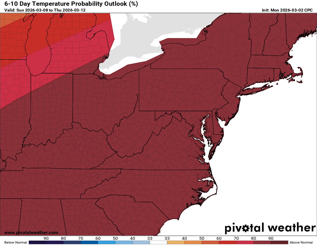
We have a chance of rain every day because a front dividing the cooler and warm air is really close by. We have a chance of at least some showers daily and temperatures 70 degrees or warmer from Friday through the weekend.

🌡️ The long range will have well above normal temperatures!

The forecast:
Today: Hi 39 ❄️70% Lo 26 🌧️80% – Snow likely during the afternoon with a wintry mix of snow, freezing rain, and sleet overnight

Tuesday: Hi 46 🌧️80% Lo 31 🌧️80% – Rain and freezing rain possibly mixed with snow early, transitioning to rain

Wednesday: Hi 64 🌧️60% Lo 43 🌧️50% – Rain likely, mainly in the afternoon

Thursday: Hi 73 🌦️30% Lo 51 🌧️40% – Mostly cloudy with a chance of rain

Friday: Hi 75 🌦️30% Lo 55 ☁️ – Partly sunny with a chance of rain

Saturday: Hi =75 🌦️ Lo 58 – Partly sunny with a chance of rain

Sunday: Hi 70 🌦️40% Lo 56 🌧️40% – Mostly cloudy with rain

#loudoun #loudouncountyva #vawx #loudounweather #loudounva #virginiaweather

Please support Tree of Life Ministries, an important organization to me! https://www.tolministries.org


image.png
image.png