Local weather. A little perspective.Loudoun County, VirginiaOfficial NWS alerts β†—
Loudoun County, Virginia

Author: admin

Loudoun County Weather Outlook for Thursday, July 11, 2024

Slurpee day! πŸ™‚ It will not be as hot and humid today. It definitely feels better this morning.Β 
Things are looking better for rain tomorrow, but I don't know how much. We really need the rain. That front stalling I mentioned earlier this week is likely too far east for us, so I would not expect much unless we get some thunderstorms.
It will get dangerously hot again early next week, with several chances of 100+ degrees for the actual high. We will likely meet the Excessive Heat Warning criteria many have wondered about.Β 
The forecast:
Today: Hi 89 Lo 68 πŸŒ€οΈπŸŒ™ – Mostly sunny with a light northwest wind, becoming partly cloudy with a light north wind at night.
Friday: Hi 82 Lo 70 β›ˆοΈβ›ˆοΈ 60% – Partly sunny with showers and thunderstorms likely in the afternoon, continuing into the night with calmer winds.
Saturday: Hi 92 Lo 71 β˜€οΈ β›ˆοΈ 30% – Mostly sunny with a chance of showers and thunderstorms in the afternoon, mostly clear at night.
Sunday: Hi 96 Lo 71 β˜€οΈπŸŒ™ πŸ₯΅ – Sunny and mostly clear.
Monday: Hi 98 Lo 73 β˜€οΈπŸŒ™ πŸ₯΅πŸŒ‘️ – Sunny and hot, mostly clear at night.
Tuesday: Hi 99 Lo 74 β˜€οΈπŸŒ™ πŸ₯΅πŸŒ‘️ – Sunny and hot, partly cloudy at night.
Wednesday: Hi 97 β˜€οΈ β›ˆοΈ 40% πŸ₯΅ – Mostly sunny and hot with a chance of showers and thunderstorms.
The long-range starts well above normal for temperatures, but for the first time in a while, the longer-range shows us getting closer to normal temperatures. Normal temperatures this time of year are still in the upper 80s, as we are in the hottest stretch of the year! There is still a slightly above-normal chance for rain, but we have not capitalized on this here!Β 
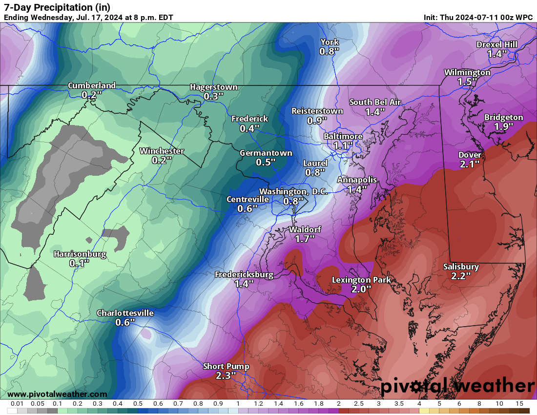
Attached is the rain outlook for the next 7 days. You can see how close the heavier rains are and it is painful for our backyards.Β 
image.png

Loudoun County Weather Outlook for Tuesday, June 25, 2024

Heating back up today, but the humidity will only slowly increase.Β 
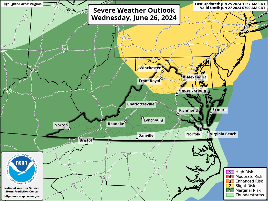
It will be hot tomorrow, but how hot it is will depend on how soon clouds arrive, and, potentially, showers and storms. The storms tomorrow could be strong to severe, posing a risk of strong winds.Β 
More reasonable summer temps return on Thursday and Friday. We have more 90s coming this weekend, but scattered showers and storms are also possible.Β 
The forecast:Β 
Today: Hi 92 Lo 70 β˜€οΈπŸŒ™ – Sunny with light and variable winds, becoming partly cloudy at night with southwest winds
Wednesday: Hi 97 Lo 68 πŸŒ€οΈβ›ˆοΈ 50% – πŸ₯΅ Partly sunny, hot, and humid with a chance of afternoon showers and thunderstorms, becoming mostly cloudy with likely showers and thunderstorms at night
Thursday: Hi 86 Lo 63 πŸŒ€οΈπŸŒ™ 30% – Mostly sunny with a slight chance of morning showers and thunderstorms, becoming mostly clear at night
Friday: Hi 87 Lo 70 πŸŒ€οΈπŸŒ™ – Mostly sunny during the day, becoming mostly cloudy at night
Saturday: Hi 91 Lo 74 πŸŒ€οΈβ›ˆοΈ 40% – Partly sunny with a chance of afternoon showers and thunderstorms, remaining mostly cloudy at night with continued chances of showers and thunderstorms
Sunday: Hi 92 Lo 65 πŸŒ€οΈβ›ˆοΈ 50% – Partly sunny with a chance of showers and thunderstorms throughout the day and night, becoming partly cloudy later
Monday: Hi 83 Lo 61 β˜€οΈπŸŒ™ – Cooler, Sunny and mostly clear
We could cool briefly next Monday, but temps are looking to turn hot and conditions drier as we head towards the Fourth of July.
Attached is the NOAA NWS Storm Prediction Center outlook risk for severe storms TOMORROW showing a slight risk (2 out of 5 on their scale)
image.png

Loudoun County Weather Outlook for Sunday, June 23, 2024

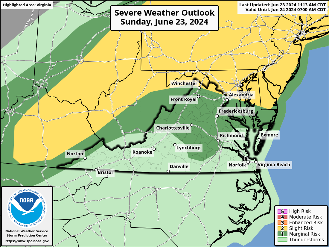
6/23/2024 – Another HOT ONE with a heat advisory, but relief is on the way as a front IS on the way today! It will swing through late today/tonight and MIGHT bring some showers and storms (we can hope!). With it being so hot, we also have the possibility of severe storms, the biggest threat being severe winds.
We will get a break tomorrow with less humidity and lower temperatures.Β 
Temps will return to the 90s Tuesday and even hotter Wednesday with another threat of heat advisory conditions.Β 
We have a better chance of showers and storms on Wednesday. Then, we will be a bit cooler on Thursday and have a few more showers. Unfortunately, temperatures will remain hot, from the upper 80s to the low and mid-90s, as we get into next weekend. The heat does not seem to want to go anywhere as we head into the following week.Β 
The forecast:
Heat advisory until 7pm
Sunday: Hi 95 Lo 72 β›ˆοΈπŸŒ™ 30% – πŸ₯΅HOT! Mostly cloudy with scattered showers and thunderstorms in the afternoon and evening
Monday: Hi 87 Lo 62 β˜€οΈπŸŒ™ – Sunny and mostly clear
Tuesday: Hi 90 Lo 69 β˜€οΈπŸŒ™ – Sunny, becoming partly cloudy in the evening
Wednesday: Hi 96 Lo 70 β›ˆοΈπŸŒ™ 40% – πŸ₯΅ HOT! Mostly sunny with a chance of showers and thunderstorms, becoming mostly cloudy with likely showers and thunderstorms at night
Thursday: Hi 87 Lo 64 πŸŒ€οΈπŸŒ™ 30% – Mostly sunny with a chance of showers, mostly clear in the evening with lingering showers
Friday: Hi 89 Lo 68 β˜€οΈπŸŒ™ – Sunny, becoming partly cloudy at night
Saturday: Hi 93 Lo 70β›ˆοΈ πŸŒ™ 30% – Mostly sunny with a chance of showers and thunderstorms
The Extended forecast looks hot! Although we could get some rain next weekend, the trends look like drying conditions as we head into July!Β 
ATTACHED – This is the NOAA NWS Storm Prediction Center outlook, showing a slight risk of severe storms.
image.png

Loudoun County Weather Outlook for Tuesday, June 18, 2024

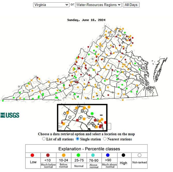
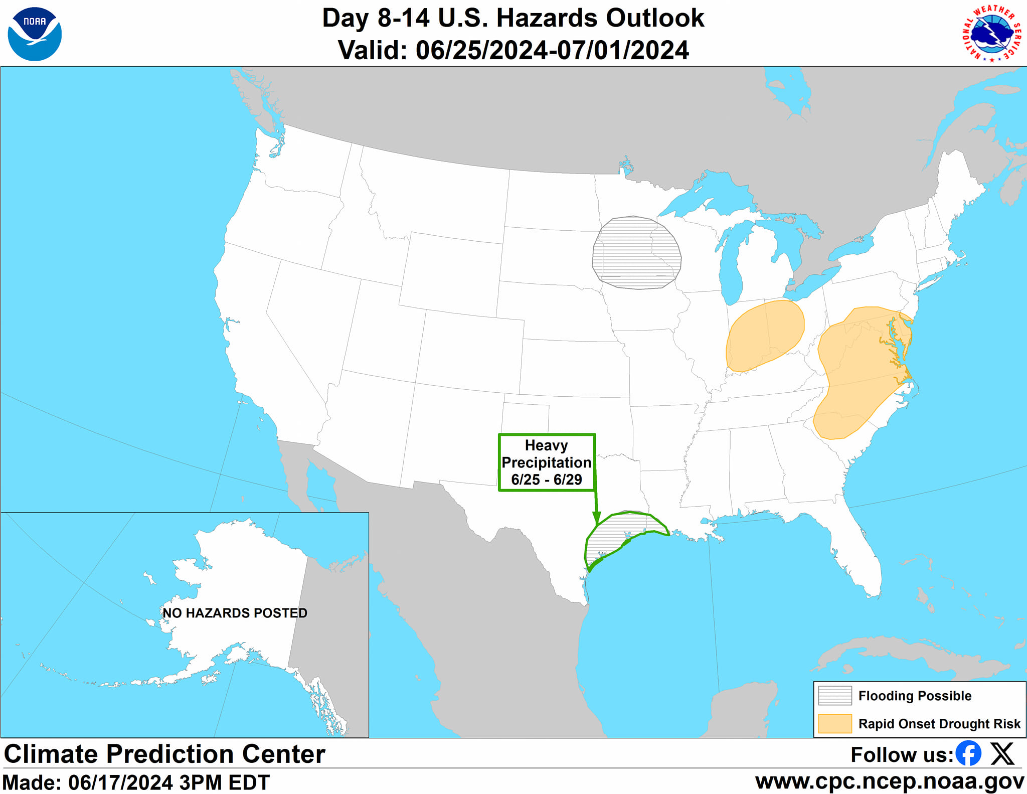
Β Another Hot One! The temps will be about like yesterday. It is possible that we could head into drought conditions soon based on the current stream levels (attached are the current stream levels), recent dryness, and the sparse precipitation chances with this intense heat.Β  The ridge of high pressure causing the heat is almost on top of us! That is drying the atmosphere enough to reduce the chances of rain. It can still storm in these hot conditions, but that is not really possible until Saturday!Β 
We could see ridge disruptions with enough instability Saturday through Monday for some storms. I am still watching models to see if severe weather will occur during that time, but this is still far enough in the future to wait for better data to know the risk.Β 
The hot forecast:
Tuesday: Hi 92 Lo 68 β˜€οΈπŸŒ™ – Mostly sunny, becoming mostly clear
Wednesday: Hi 89 Lo 68 β˜€οΈπŸŒ™ – Sunny and mostly clear
Thursday: Hi 91 Lo 71 β˜€οΈπŸŒ™ – Sunny and mostly clear
Friday: Hi 95 Lo 71 πŸŒ€οΈπŸŒ™ – πŸ₯΅ Mostly sunny, becoming partly cloudy
Saturday: Hi 96 Lo 72 β›ˆοΈπŸŒ™ 30% – πŸ₯΅ Sunny with a chance of afternoon showers and thunderstorms
Sunday: Hi 95 Lo 73 β›ˆοΈπŸŒ™ 30% – πŸ₯΅ Mostly sunny with a chance of showers and thunderstorms
Monday: Hi 91 Lo 69 β›ˆοΈπŸŒ™ 40% – Mostly sunny with a chance of showers and thunderstorms
image.png
image.png

Loudoun County Weather Outlook for Thursday, June 13, 2024

The heat returns next week as we hit an honest heat wave potential with daily temps above 90. The setup looks dry, which will stress plants and lawns! You may want to mow your grass high this week if it will not get regular watering!Β 
The forecast:
Thursday: Hi 88 Lo 66 πŸŒ€οΈπŸŒ™ 20% – Mostly sunny with increasing winds. Isolated showers before midnight, becoming mostly clear.
Friday: Hi 92 Lo 63 β›ˆοΈ πŸŒ™ 30% – Mostly sunny with a chance of showers and thunderstorms in the afternoon and evening, then becoming mostly clear.
Saturday: Hi 84 Lo 58 β˜€οΈπŸŒ™ – Sunny and mostly clear.
Sunday: Hi 86 Lo 66 β˜€οΈπŸŒ™ – Sunny with partly cloudy conditions at night.
Monday: Hi 92 Lo 71 πŸŒ€οΈπŸŒ™ – Mostly sunny with partly cloudy conditions at night.
Tuesday: Hi 93 Lo 71 πŸŒ€οΈπŸŒ™ – Mostly sunny with partly cloudy conditions at night.
Wednesday (Juneteenth): Hi 94 Lo 74 πŸŒ€οΈπŸŒ™ – Mostly sunny.
The Extended forecast continues to look hot and dry for now!