Local weather. A little perspective.Loudoun County, VirginiaOfficial NWS alerts ↗
Loudoun County, Virginia

Author: admin

Loudoun County Weather Outlook for Friday, August 2, 2024

IT IS HOT! A Heat Advisory kicks in at noon and ends at 8pm. The rain focus has been hard to pinpoint the last few days. I am NOT HAPPY with the trends being east of us but, we can get some prolific rainers where storms can form.

We have a marginal risk (1 out of 5) for a severe storm, and wind would be the main threat. There are some hints that it could be raised today and tomorrow. I will be watching.

There are signs that we will get back to normal temperatures later next week and a continued chance of above-average rain.

THERE IS A CHANCE that we could get some influence from the tropical system that will be impacting the southeast. I do not have much confidence for us, but anyone heading to the beaches in the Southeastern US from Virginia to Florida should be thinking of some non-beach things to do because this system is going to be a problem! From rain to rough seas, this system could be a problem. SO MUCH UNKNOWN for now, but I will be updating as we look at the system through the weekend.

The forecast:
Today: Hi 97 ⛈️60% Lo 72 ⛈️60% 🌡️ – 🥵 Scattered showers and thunderstorms likely, becoming more frequent after 3pm. Mostly sunny and hot, with heat index values up to 104.

Saturday: Hi 90 ⛈️70% Lo 70 ⛈️60% – Isolated showers in the morning, then showers and thunderstorms likely from late morning.

Sunday: Hi 88 ⛈️50% Lo 69 🌙30% – A chance of showers and thunderstorms, especially after 11am.

Monday: Hi 94 ☀️ Lo 69 🌙 – 🥵 Sunny and mostly clear.

Tuesday: Hi 91 🌤️ Lo 68 ⛈️30% – Mostly sunny during the day. A chance of showers and thunderstorms at night.

Wednesday: Hi 87 🌤️30% Lo 66 ⛈️30% – Mostly sunny with a chance of showers and thunderstorms throughout the day and night.

Thursday: Hi 86 🌤️30% Lo 66🌙 – Mostly sunny with a chance of showers.

The total rain forecast for the next seven days is attached. You can note the downward trend from yesterday, but 1 to 2 inches is not bad! We can hope!
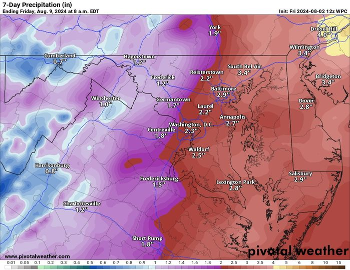
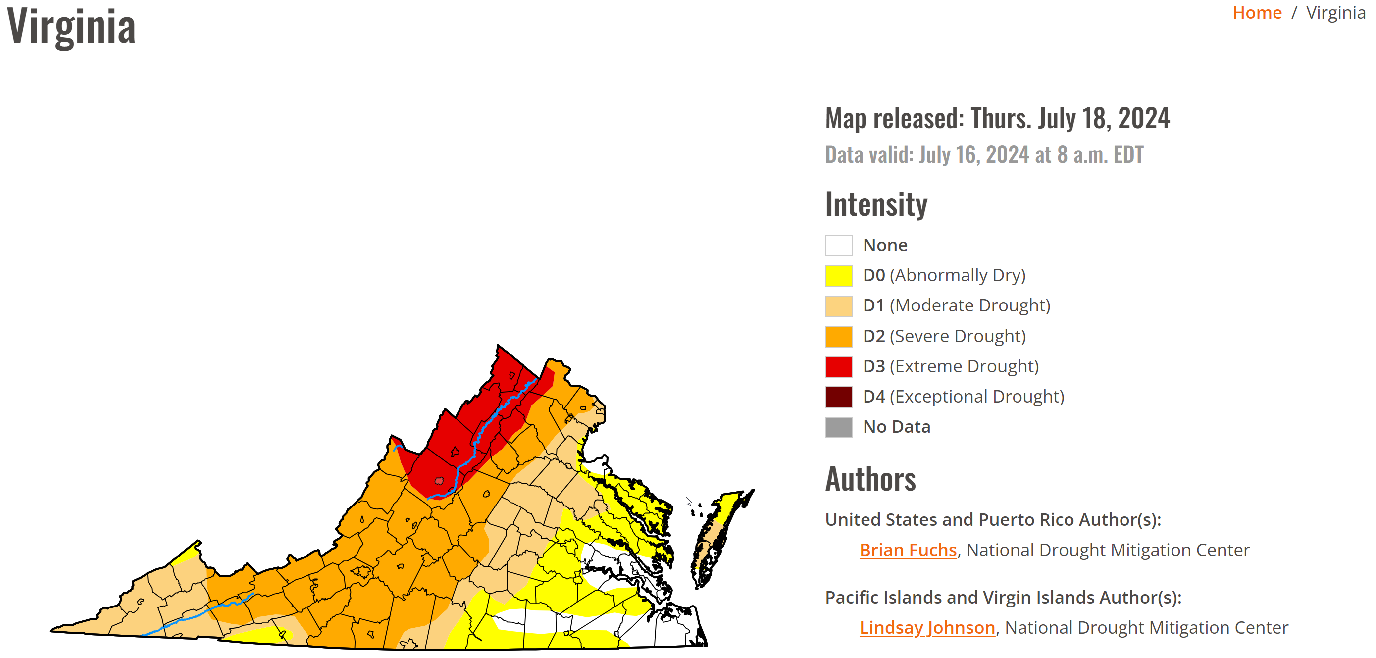
image.png

Loudoun County Weather Outlook for Thursday, August 1, 2024

Welcome to the start of the last month of meteorological summer! It will be hot, and we have a chance of showers and storms over the next few days. With the humidity and heat combined, we will feel close to 100 to 105 at times today and tomorrow! Just nasty hot weather! We need any rain we can get, and there is an enhanced chance of getting it over the next several days. Storms that do form could produce locally heavy rainfall. Additionally, the NOAA NWS Storm Prediction Center has us at a marginal risk of severe (1 out of 5). 
The extended remains above normal with temperatures and a chance of above-average rain chances! We could see closer-to-normal temperatures in the longer range. 
The forecast:
Today: Hi 95 ⛈️40% Lo 72🌙30% – 🥵 Scattered showers and thunderstorms, partly cloudy
Friday: Hi 95 ⛈️70% Lo 72 ⛈️70% – 🥵 Showers and thunderstorms likely, mostly cloudy
Saturday: Hi 91 ⛈️80% Lo 70 ⛈️80% – Showers and thunderstorms likely
Sunday: Hi 88 ⛈️50% Lo 69 🌙 – Partly sunny with a good chance of showers and storms, mostly clear at night
Monday: Hi 93 ☀️ Lo 68 🌙 – Sunny, partly cloudy at night
Tuesday: Hi 89 ☀️ Lo 70 🌙 – Sunny, mostly clear at night
Wednesday: Hi 90 ⛈️40% Lo 70 🌙 – Mostly sunny with a chance of showers and thunderstorms
Please support Tree of Life Ministries, an important organization to me! https://www.tolministries.org

Loudoun County Weather Outlook for Thursday, July 18, 2024

The drought has gotten worse and is extremely bad in far western Loudoun. The latest drought monitor shows Extreme Drought. Yesterday's rain was around a quarter to half an inch for many, but many did not see that much. 
We are entering an unsettled time, and I am hopeful some rain chances will pan out over the next week! We need it bad. 
Temps will be near normal, which, for this time of year, is the upper 80s to 90 degrees.
YES, we get a break from the humidity today and tomorrow which will make it nicer to be outside. 
The extended forecast is showing temperatures slightly above average and slightly above normal rain chances. 
The forecast that does show quite a few chances for rain starting Saturday:
Today: Hi 88 🌤️ Lo 63 🌙  – Mostly cloudy with north wind around 7 mph during the day and partly cloudy with north wind 3 to 6 mph at night.
Friday: Hi 88 ☀️ Lo 68 🌙  – Sunny with north wind around 6 mph becoming calm in the afternoon. 
Saturday:  Hi 83🌤️⛈️50% Lo 66  ⛈️ 30%  – Mostly cloudy with a chance of showers and thunderstorms in the afternoon. 
Sunday: Hi 89 🌤️⛈️ 30%  Lo 68 🌧️ 30%  – Mostly sunny with a chance of showers and thunderstorms in the afternoon. Mostly cloudy with a chance of showers and thunderstorms at night.
Monday: Hi 87 🌤️⛈️ 50% Lo 69 🌧️ 40%   – Partly sunny with a chance of showers and thunderstorms in the afternoon. Mostly cloudy with a chance of showers and thunderstorms at night.
Tuesday: Hi 88 🌤️⛈️ 60%  Lo 70 🌧️ 60% – Partly sunny with showers and possibly a thunderstorm. Mostly cloudy with showers and thunderstorms likely at night.
Wednesday: Hi 88 🌤️⛈️ 70% – Partly sunny with showers and possibly a thunderstorm.
#loudoun #loudouncountyva #vawx #loudounweather #loudounva #virginiaweather
Please support Tree of Life Ministries, an important organization to me! https://www.tolministries.org
image.png

Loudoun County Weather Outlook for Monday, July 15, 2024

Just plain ridiculously hot today and tomorrow. With the slight westerly winds, the dewpoints will come down a bit, making the heat index around 105 today and not the super hot ones we could have had. That is why we are in a heat advisory, not an Excessive Heat Warning. That slight drying from the winds coming down the mountains will keep the air a touch drier. What is not clear is if that also will translate into higher temps than forecast. I would not be surprised if it does. When air sinks, it warms, and it could make us a few degrees hotter than forecast. It is also possible some clouds and showers or storms could help lower the highs.. we can hope, but westerly winds are not good for showers and storms either. 
The break will come on Wednesday. AGAIN, I do NOT LIKE the trajectory of the front and winds. This has already influenced the expected rain totals and brought them down some. That is not a trend we want to see. I do think we will see some showers and some storms around the area on Wednesday, but these could be too little or not well organized, which would make us see less rain! :
We will “cool” to near average temps from Thursday through the weekend. Things look a bit unsettled for the weekend, which could mean showers and storms in the afternoon. We can hope. 
The extended gives me hope that the next few days will be the hottest stretch of summer and that we will be near normal for the next few weeks. It is still pretty hot, but maybe not so oppressive! 
Stay cool, drink fluids, and be sensitive to your pet's and animal's needs. Check on neighbors and make sure they have good AC. Do what you can to help those in the sweltering heat! 
The forecast:
Today: Hi 99 Lo 72 🥵🌡️🌤️ ⛈️ 30%  – 🥵 Sunny and hot with scattered showers and thunderstorms in the afternoon. Heat index values as high as 106. Partly cloudy with scattered showers and thunderstorms in the evening.
Tuesday: Hi 101 Lo 74 🥵🌡️☀️ ⛈️20% – 🥵 Sunny and hot with a slight chance of showers and thunderstorms in the afternoon. Heat index values as high as 107. Partly cloudy with a slight chance of showers and thunderstorms at night.
Wednesday: Hi 95 Lo 71 🌤️⛈️ 70%  ⛈️60% – 🥵 Partly sunny with showers and thunderstorms likely in the afternoon. 
Thursday: Hi 85 Lo 63 🌤️ 30% 🌙 – Cooler! Partly sunny with a chance of showers. 
Friday: Hi 86 Lo 66 🌤️- Mostly sunny
Saturday: Hi 84 Lo 67 🌤️ 30%  – Partly sunny with a chance of showers. Mostly cloudy with a chance of showers at night.
Sunday: Hi 87 🌤️⛈️ 30% – Partly sunny with a chance of showers and thunderstorms.

Loudoun County Weather Outlook for Friday, July 12, 2024

Some rain – but NOT A LOT! This will be a painful day for us, especially in western Loudoun. Unless we get some thunderstorms, the rain may be less than a tenth of an inch. The radar looks great to our south, but the rain dries up as it gets close to Loudoun. This is the pattern, and this will likely be the case. It is possible that people in far eastern Loudoun will get some more significant rain, maybe up to half an inch. 
We are going to really heat up Sunday through Wednesday. A few 100+ days are possible. Rain chances will return later next week and we will need to watch for the potential of severe weather. 
There seems good support for a brief break in temperatures coming in the long range. 
The forecast:
Today: Hi 78 Lo 70 ⛈️⛈️ 90% – Showers and thunderstorms likely, then showers and possibly a thunderstorm after 2pm. Light east wind.
Saturday: Hi 91 Lo 71 🌤️🌙 20% – Isolated showers and thunderstorms, mostly sunny during the day and partly cloudy at night with calm wind.
Sunday: Hi 96 Lo 71 ☀️🌙  – 🥵 Sunny and HOT!
Monday: Hi 99 Lo 73 ☀️🌙  – 🥵🌡️ Sunny and VERY HOT!
Tuesday: Hi 99 Lo 73 ☀️🌙  – 🥵🌡️Sunny and VERY HOT!
Wednesday: Hi 96 Lo 68 ⛈️⛈️ 50% 🥵 – Very Hot with a chance of showers and thunderstorms. 
Thursday: Hi 85 ⛈️🌙 40% – A chance of showers and thunderstorms, mostly sunny and cooler!
As mentioned. The longer range shows temps heading to normal and even below normal if the models are correct. Still time enough that this could change. We will watch.