Local weather. A little perspective.Loudoun County, VirginiaOfficial NWS alerts ↗
Loudoun County, Virginia

Author: admin

Loudoun County Weather Outlook for Thursday, August 15, 2024

 The weather remains beautiful today but is turning hotter with highs in the upper 80s. 
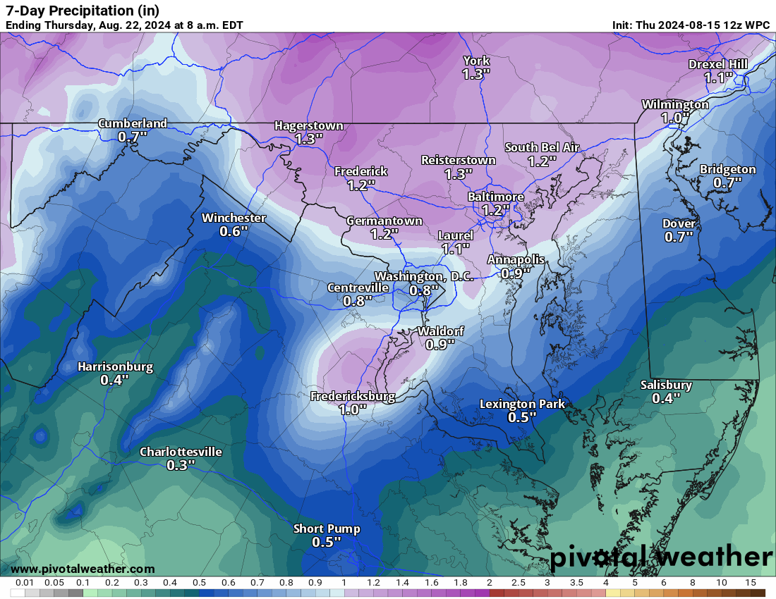
Rain chances return tomorrow night and last through Monday. The weather turns beautiful on Tuesday!
The Drought is better but still ongoing. I've attached the comparison from last week. The left is the new drought monitor, and the right is from a week ago. Each is improved by one severity level. We still need several more inches of rain region-wide to reverse the drought! Basically, we are better but we need more rain! 
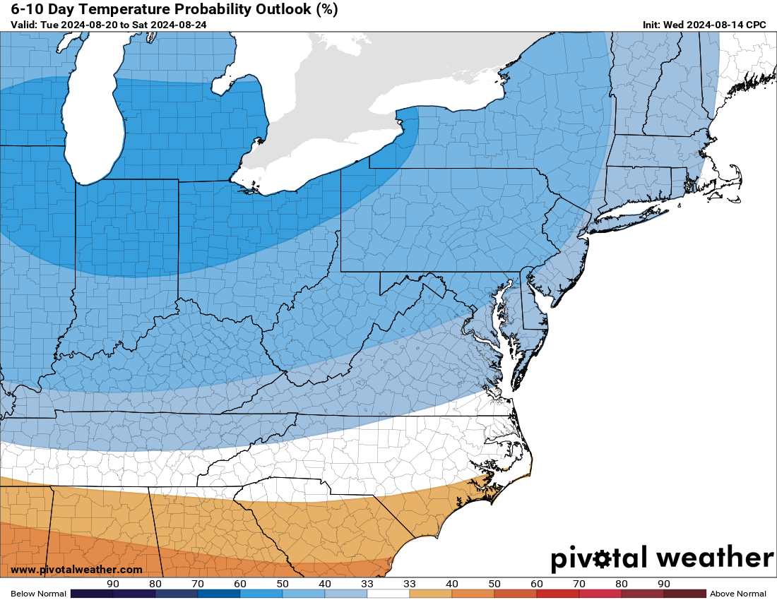
The long range is now influenced by the track of Ernesto, the strong hurricane well off the east coast. The interaction of the hurricane and a trough will bring another round of below-normal temperatures to the area in the extended with some warming later. We continue with an above-normal chance of rain as well! 
The forecast:
Today: Hi 87 ☀️ Lo 63 🌙 – Sunny and mostly clear with light winds
Friday: Hi 88 ☀️ Lo 69 🌩️50% – Mostly sunny during the day with a chance of showers and thunderstorms at night
Saturday: Hi 88 🌩️60% Lo 68 🌩️60% – Partly sunny with showers and thunderstorms likely in the afternoon and night
Sunday: Hi 85 🌩️70% Lo 67 🌩️60% – Partly sunny with showers and thunderstorms likely throughout the day and night
Monday: Hi 83 🌩️60% Lo 64 🌩️60% – Partly sunny with showers and thunderstorms likely in the afternoon and evening
Tuesday: Hi 81 ☀️ Lo 58 🌙 – BEAUTIFUL Sunny and mostly clear
Wednesday: Hi 81 ☀️ Lo 55 🌙- BEAUTIFUL! Sunny and clear
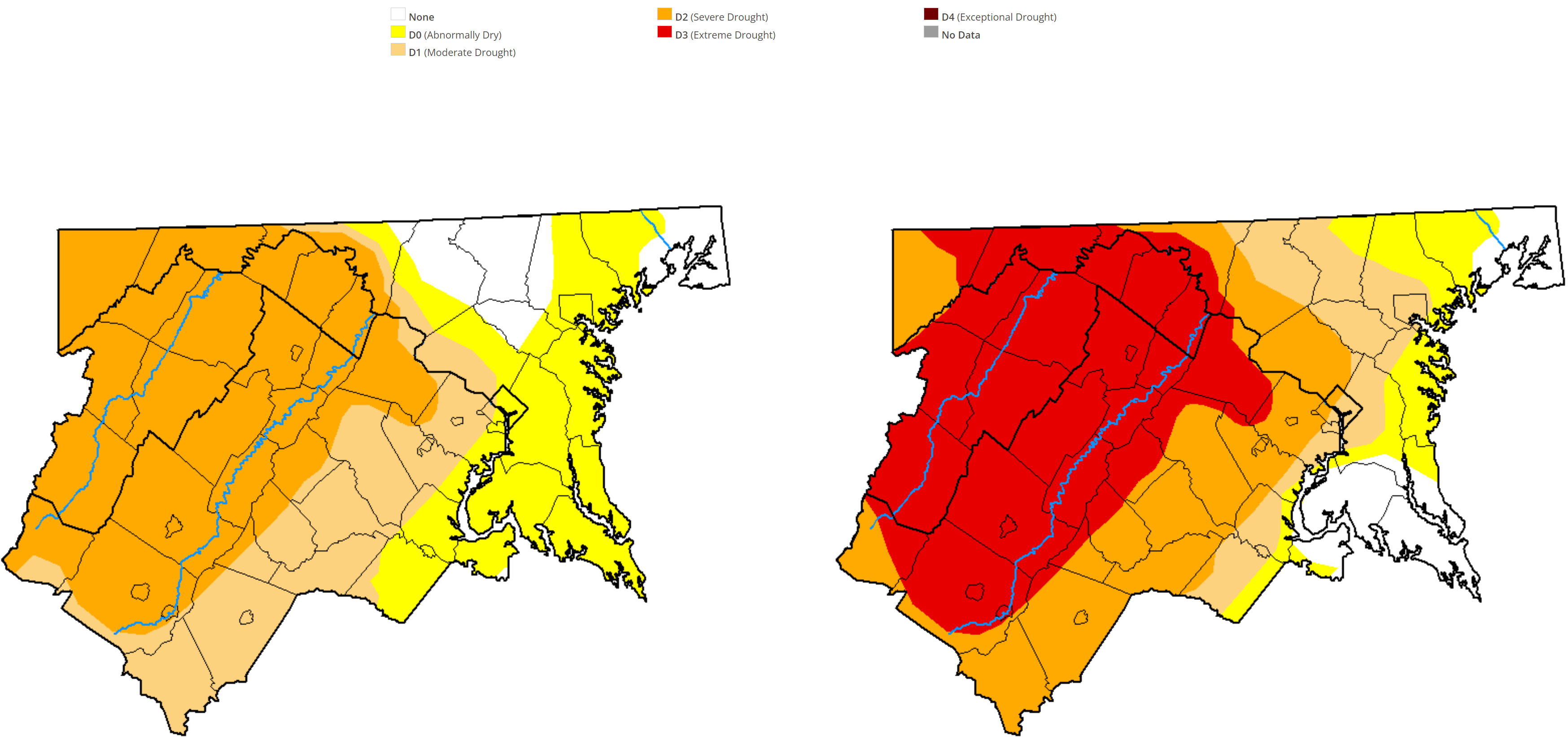
image.png
image.png
image.png

Loudoun County Weather Outlook for Tuesday, August 13, 2024

The weather is just beautiful today! The high will be in the low 80s, and we continue with lower humidity! This is the sweetness of summer weather. 
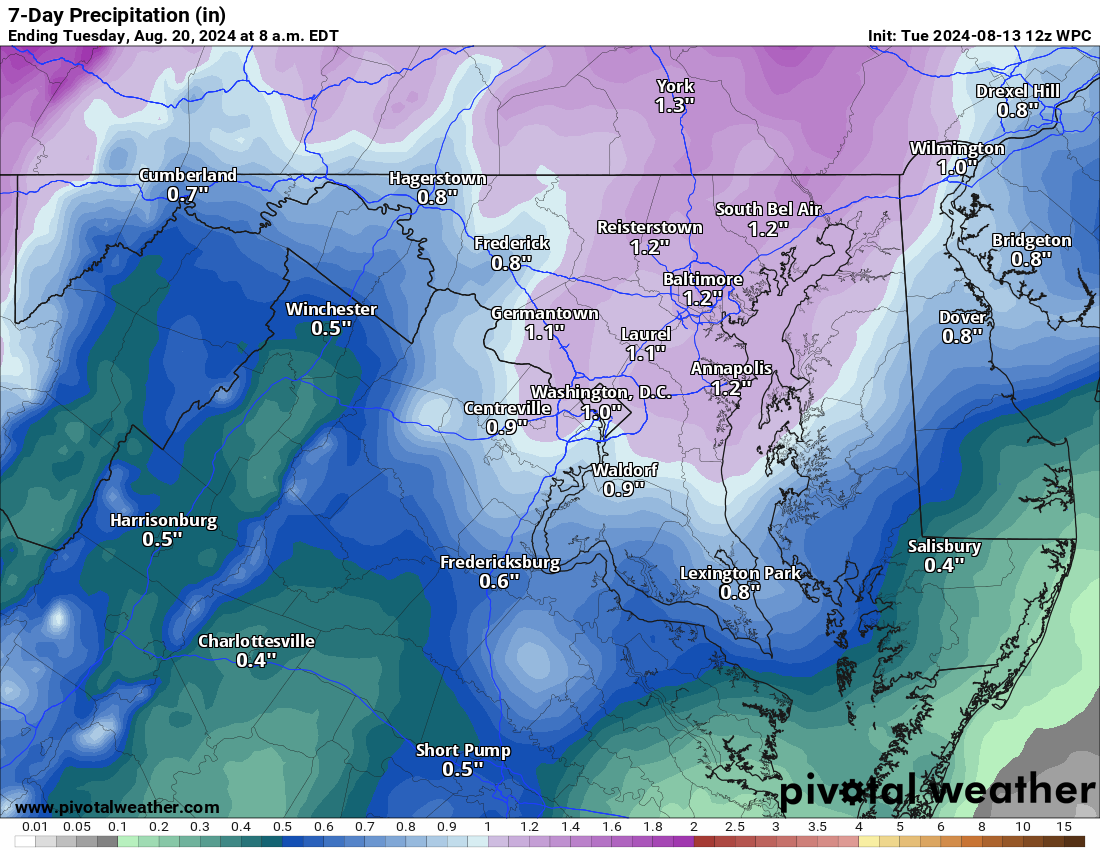
Rain chances return Friday through Monday, but this will not be a washout. 
The extended now does show the temperatures staying near normal which has come down to the mid-80s as we get later into August! It also shows a continued chance for above average rainfall. This is a great way to end Summer. I have a strong feeling as we start September, we could see some heat return for a bit.  
The forecast:
Today: Hi 81 🌤️ Lo 60 🌙 – Mostly sunny with light winds, becoming mostly clear and calm tonight
Wednesday: Hi 84 ☀️ Lo 61 🌙 – Sunny and mostly clear with calm winds
Thursday: Hi 88 ☀️ Lo 64 🌙 – Sunny with calm winds, becoming partly cloudy at night
Friday: Hi 87 🌤️ ⛈️ 30%  Lo 69 ⛈️50% – Mostly sunny with a chance of showers an thunderstorms
Saturday: Hi 87 🌤️⛈️50% Lo 68 ⛈️40% – Mostly sunny with afternoon thunderstorms, continuing with a chance of showers overnight
Sunday: Hi 85 🌤️⛈️50% Lo 66 ⛈️30% – Mostly sunny with afternoon thunderstorms
Monday: Hi 85 🌤️⛈️40% Lo 65 – Mostly sunny with a chance of showers and thunderstorms
We do need the rain to continue weekly so we can keep the drought in check! It appears we could get some rain, so that is good! 
image.png

Loudoun County Weather Outlook for Monday, August 12, 2024

I just hope you get outside today and enjoy some of the best summer weather! 🙂
Sunny skies and comfortable nights with rain chances visiting in about a week!
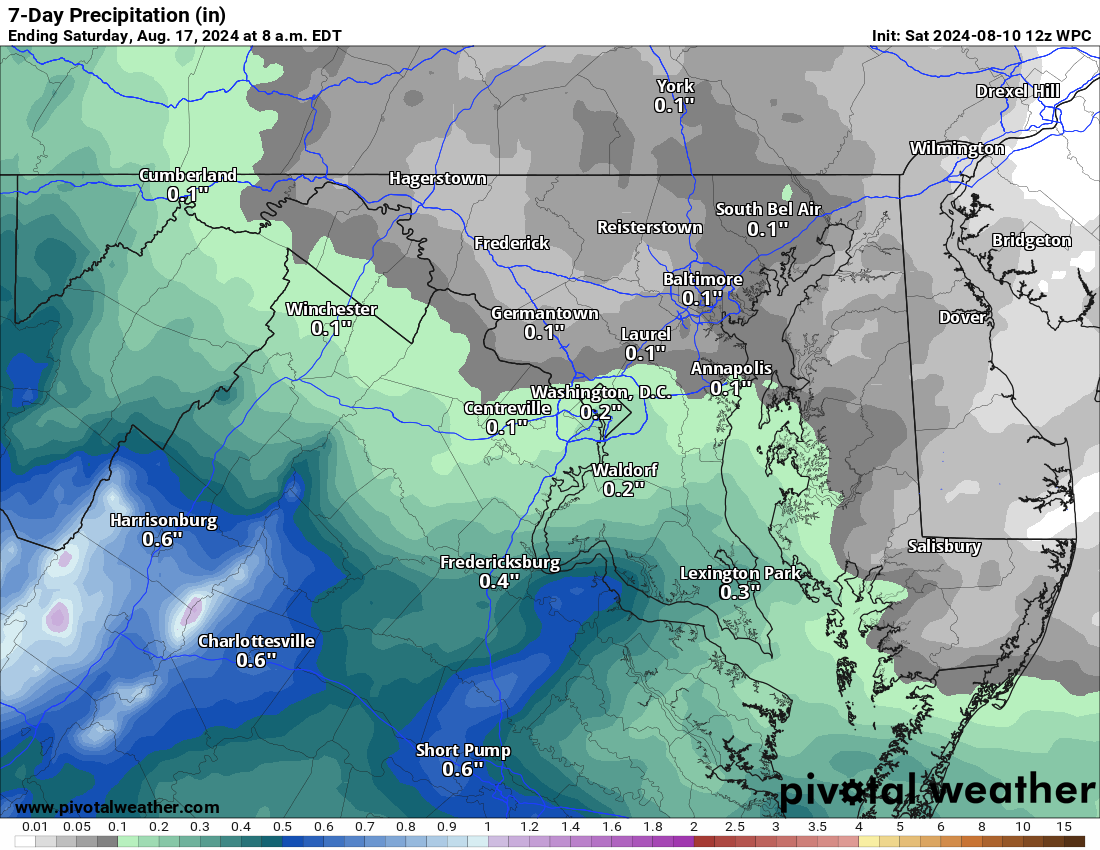
The 7-day outlook for rain has that little bit arriving next Friday! We will need some more by then! 
The Forecast
Today: Hi 85 🌤️ Lo 62 🌙 – Mostly sunny with light northwest wind, becoming partly cloudy tonight
Sunday: Hi 82 🌤️ Lo 59 🌙 – Mostly sunny with a light northwest wind, becoming partly cloudy overnight
Monday: Hi 84 ☀️ Lo 61 🌙 – Sunny with a light west wind, becoming partly cloudy at night
Tuesday: Hi 81 🌤️ Lo 61 🌙 – Mostly sunny during the day, becoming mostly clear overnight
Wednesday: Hi 84 ☀️ Lo 63 🌙 – Sunny throughout the day, becoming partly cloudy overnight
Thursday: Hi 84 🌤️ Lo 63 🌙 30% – Mostly sunny with a slight chance of showers overnight
Friday: Hi 82 🌤️⛈️40% Lo 63 ⛈️  – Mostly sunny with a chance of showers and thunderstorms during the day, and showers overnight
#loudoun #loudouncountyva #vawx #loudounweather #loudounva #virginiaweather
Please support Tree of Life Ministries, an important organization to me! https://www.tolministries.org

Loudoun County Weather Outlook for Saturday, August 10, 2024

8/10/2024 – I just hope you get outside today and enjoy some of the best weather of the summer! 🙂
Sunny skies and comfortable nights with rain chances visiting in about a week!
The 7-day outlook for rain has that little bit arriving next Friday! We will need some more by then! 
The Forecast
Today: Hi 85 🌤️ Lo 62 🌙 – Mostly sunny with light northwest wind, becoming partly cloudy tonight
Sunday: Hi 82 🌤️ Lo 59 🌙 – Mostly sunny with a light northwest wind, becoming partly cloudy overnight
Monday: Hi 84 ☀️ Lo 61 🌙 – Sunny with a light west wind, becoming partly cloudy at night
Tuesday: Hi 81 🌤️ Lo 61 🌙 – Mostly sunny during the day, becoming mostly clear overnight
Wednesday: Hi 84 ☀️ Lo 63 🌙 – Sunny throughout the day, becoming partly cloudy overnight
Thursday: Hi 84 🌤️ Lo 63 🌙 30% – Mostly sunny with a slight chance of showers overnight
Friday: Hi 82 🌤️⛈️40% Lo 63 ⛈️  – Mostly sunny with a chance of showers and thunderstorms during the day, and showers overnight
image.png

Loudoun County Weather Outlook for Thursday, August 8, 2024

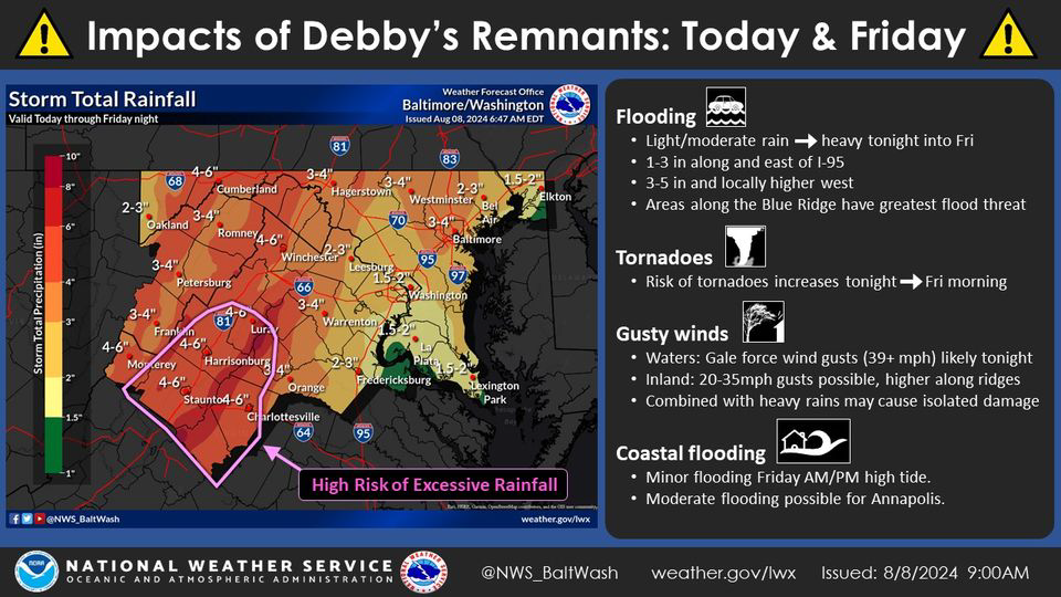
The Forecast and Debby Update – You can see in the attached from US National Weather Service Baltimore/Washington that the remaining rains, directly from Debby, are now in the 1.5 to 3-inch range for Loudoun. I agree with this as the storm is going to be picked up well with the trough, which will help bring cooler/dryer air this weekend and accelerate it northwards. The storm is now expected to be far enough west to keep that heavier swath of rain to the west as well. 1.5 to 3 inches of rain is great. Of note, there could still be training storms that happen in localized areas, and these could drop several inches of rain. Where/If these set up will be a radar watching and short-term outlook.
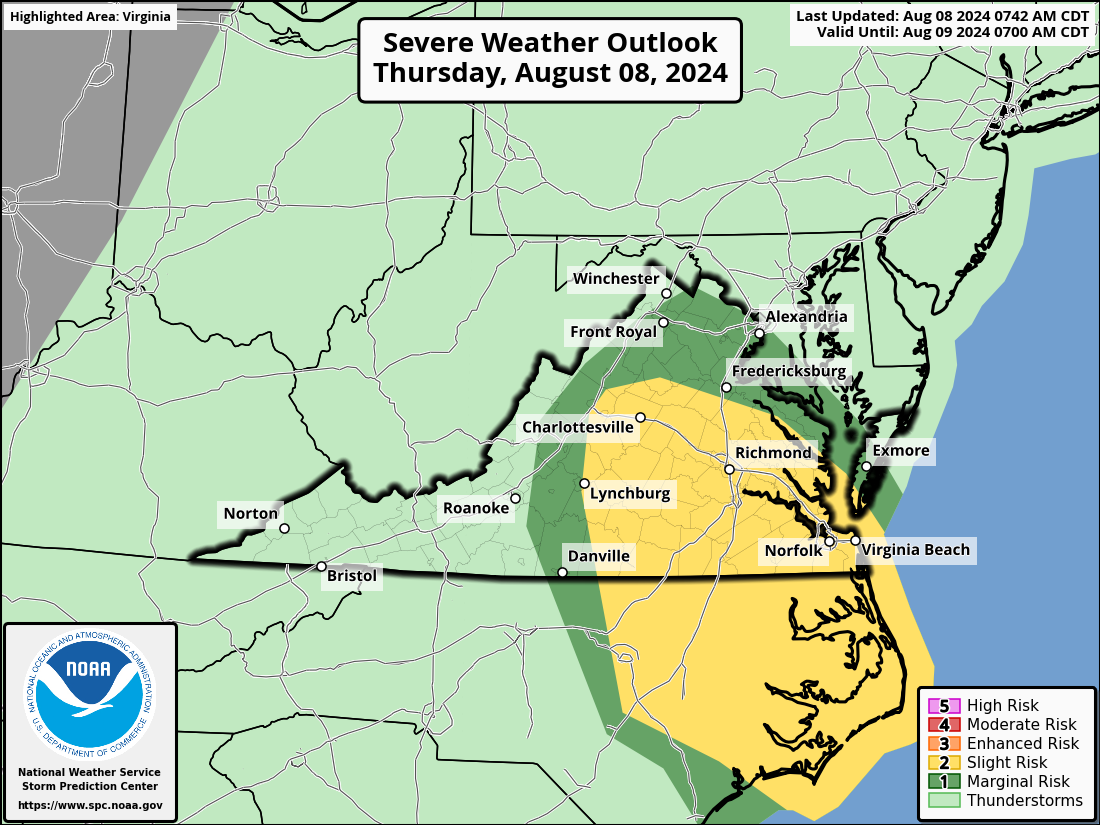
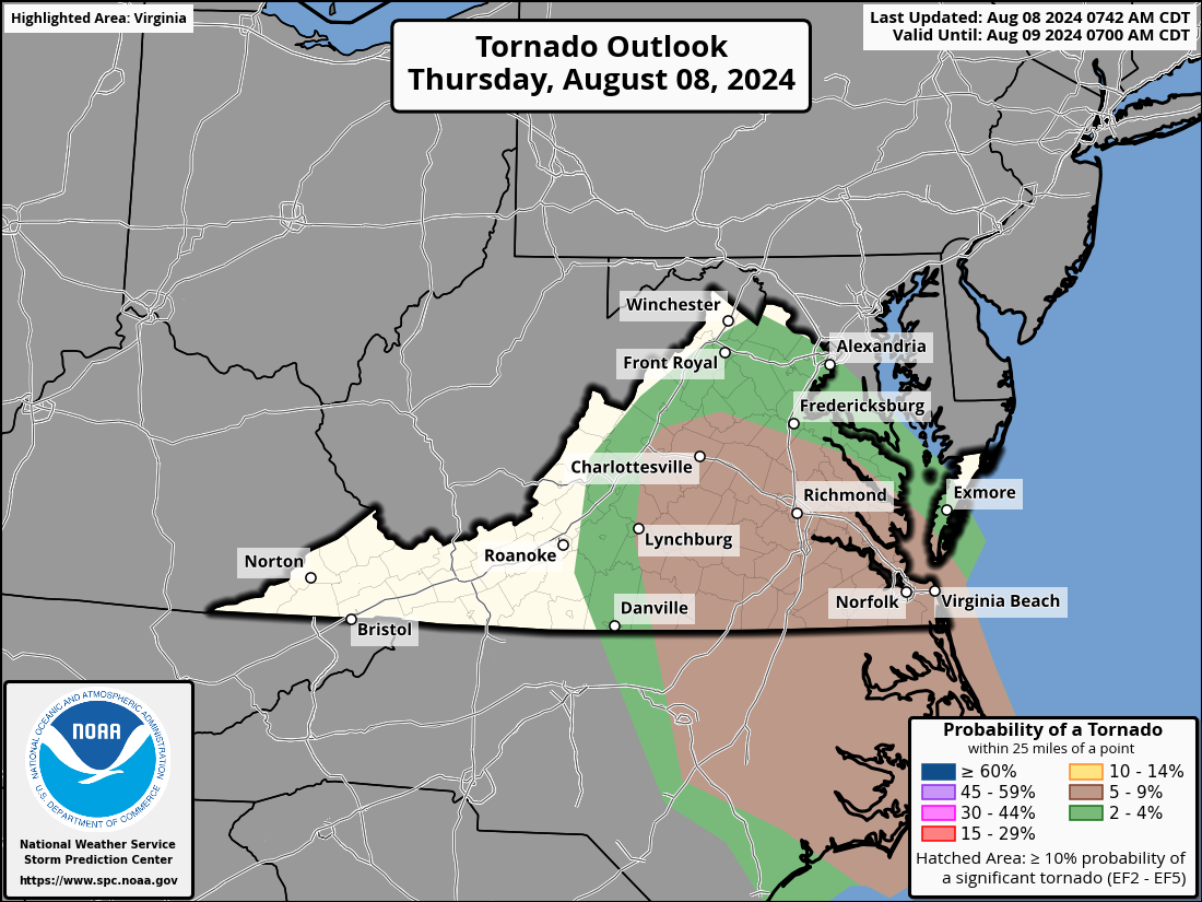
Severe threat: Although there is a risk of tornadoes, it is not that great. I've attached the outlook, and I'll be watching for updates later as the storm approaches. Storms could still produce gusty winds.
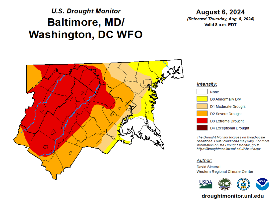
The weather turns so lovely after this, and we look dry from late Friday through next Wednesday. We will see what impacts the recent rain has on the drought, but we will remain in a drought. However, some locations will be dropped from the extreme and moderate drought. I attached the latest monitor that only counted rain through Tuesday morning.  
The  Forecast:
Today: Hi 78 ⛈️80% Lo 73 ⛈️90% – Showers and possibly a thunderstorm. Some storms could produce heavy rainfall with gusty winds.
Friday: Hi 81 ⛈️100% Lo 67 🌙40% – Showers and thunderstorms, heavy rainfall possible. Chance of showers and thunderstorms at night, becoming partly cloudy later.
Saturday: Hi 82 ☀️ Lo 61 🌙 – Sunny
Sunday: Hi 82 ☀️ Lo 59 🌙 – Sunny 
Monday: Hi 84 ☀️ Lo 62 🌤️ – Sunny
Tuesday: Hi 81 🌤️ Lo 62 🌤️ – Mostly sunny 
Wednesday: Hi 84 🌤️ Lo 63 🌤️ – Mostly sunny
3f56a4ec-4d57-468c-9c97-1f713ebf7ba6.png

image.png

image.png

image.png