Local weather. A little perspective.Loudoun County, VirginiaOfficial NWS alerts β†—
Loudoun County, Virginia

The local outlook

Forecasts, updates and a little local perspective.

Loudoun County Weather Outlook for Wednesday, July 29, 2026

🌀️ Beautiful Midweek Stretch
Wednesday's shaping up nice with highs in the low 80s and a breezy northwest wind. That breeze sticks around into Thursday too, but it'll still be a great day with highs in the low to mid 80s.

β˜€οΈ Warming Up Friday and Saturday
Temperatures climb into the upper 80s both days as we head toward the weekend.

β›ˆοΈ Daily Storm Chances Return Sunday
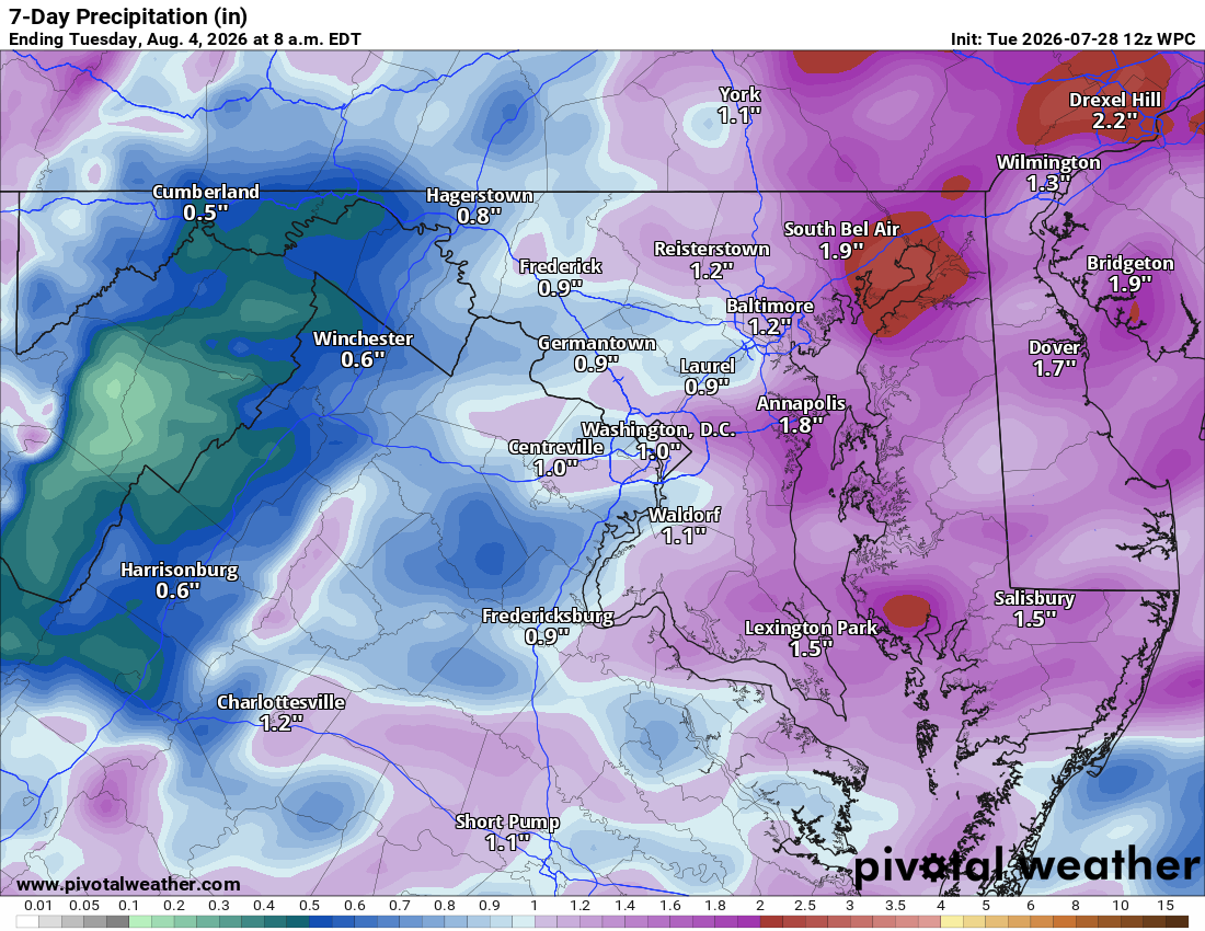
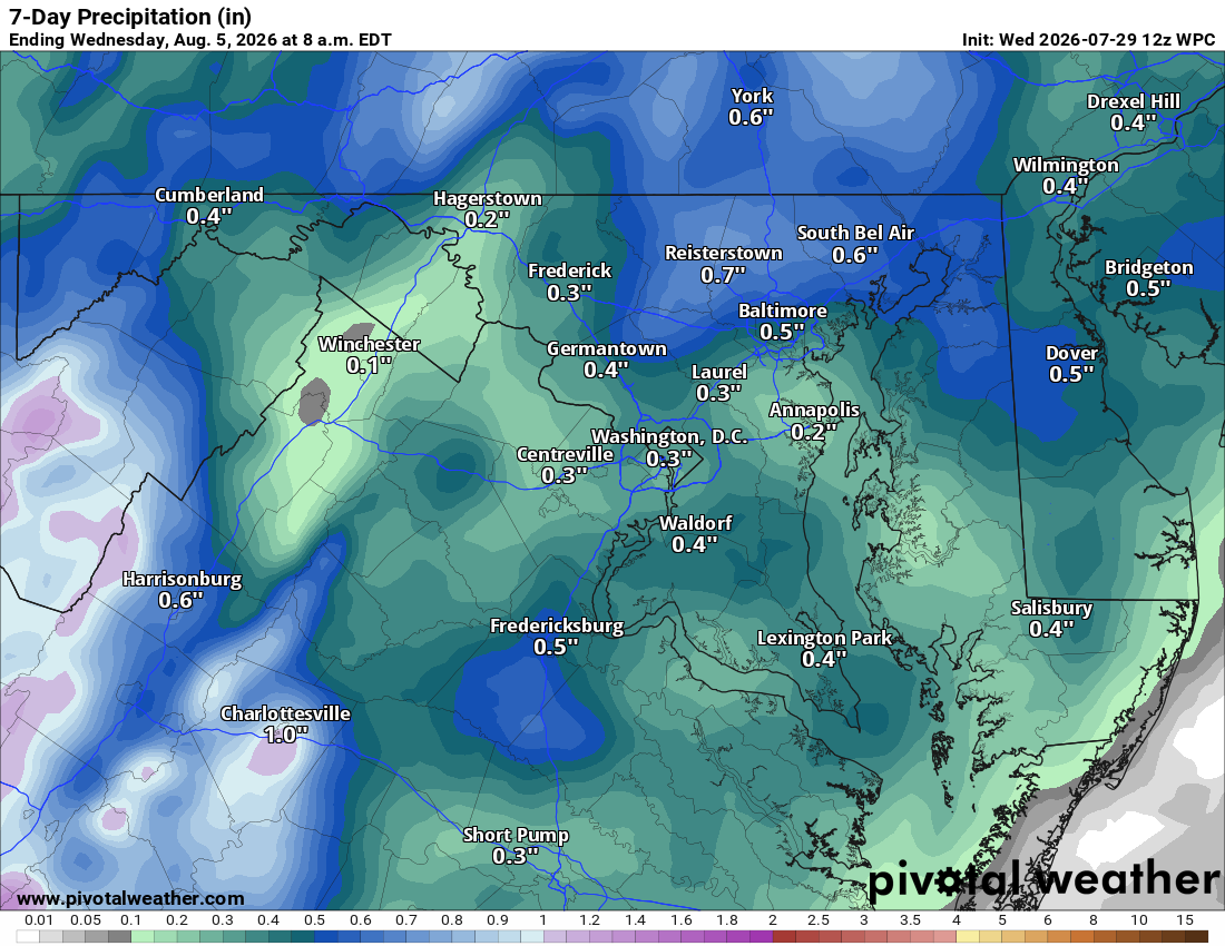
Starting Sunday and running through Monday, Tuesday, and Wednesday of next week, expect a daily chance for showers and thunderstorms. Highs stay in the mid to upper 80s through the period. Nothing looks super organized, just scattered activity, but we could use the rain.

The forecast:

Wednesday: Hi 82 🌞 Lo 64 – Sunny with breezy NW winds

Thursday: Hi 84 🌞 Lo 64 – Sunny and still breezy

Friday: Hi 86 β˜€οΈ Lo 67 – Sunny

Saturday: Hi 88 β›… Lo 69 🌧️20% – Partly sunny with a slight chance of overnight storms

Sunday: Hi 86 🌦️40% Lo 68 🌧️50% – Chance of showers and storms

Monday: Hi 85 🌧️50% Lo 68 🌧️30% – Chance of showers and storms

Tuesday: Hi 86 🌦️40% Lo 67 – Chance of showers and storms

#loudoun #loudouncountyva #vawx #loudounweather #loudounva #virginiaweather

Please support Tree of Life Ministries, an important organization to me! https://www.tolministries.org

image.png

Loudoun County Weather Outlook for Tuesday, July 28, 2026

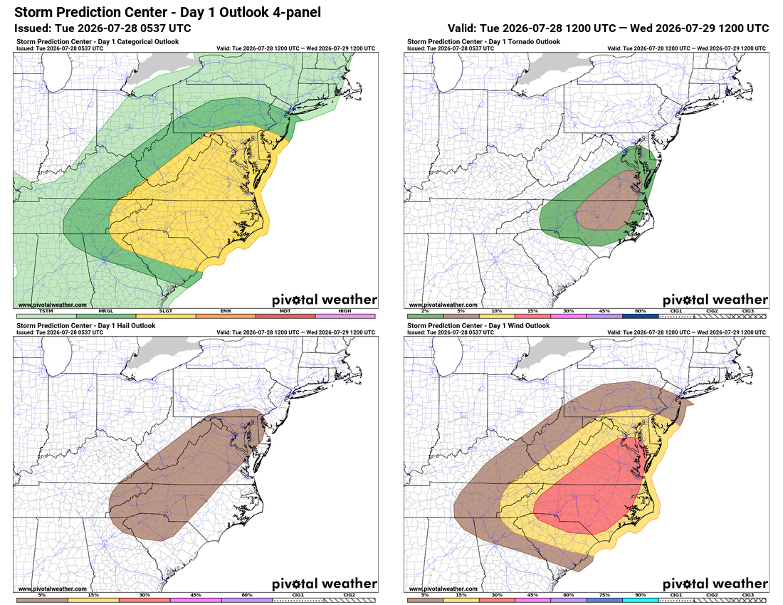
⚠️ Severe Storms Possible Today

🌧️ Showers and maybe a Storm This Morning
Showers and possibly a few storms move through this morning, tapering off by midday.

⚑ Strong to Severe Storms Possible This Afternoon
A front moves through this afternoon, and strong to severe storms are possible, though morning clouds may limit how widespread they get. Main risks are gusty winds and hail, with an isolated tornado not ruled out, mainly south and east.

🌬️ Drying Out and Turning Breezy Wednesday and Thursday
Skies clear behind the front, but winds turn breezy out of the northwest as a noreaster spins up off the coast. Highs reach around 80 to the low 80s Thursday, a nice combo of wind and cooler dry air for this time of year.

β˜€οΈ Heating Up for the Weekend
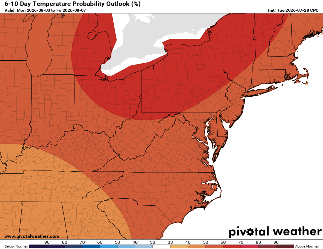
We warm back up into the weekend, with another chance for showers and storms and highs back to normal, mid to upper 80s. Next week could trend above normal for temps and rain, so enjoy this cooler stretch.

The forecast:

Today: Hi 84 β›ˆοΈ90% Lo 66 🌧️60% – Showers and storms likely through the day, tapering off in the evening. Winds becoming westerly, gusting up to 18 mph.

Wednesday: Hi 82 🌞 Lo 65 – Sunny and pleasant with breezy northwest winds gusting up to 28 mph.

Thursday: Hi 82 🌞 Lo 64 – Mostly sunny with northwest winds gusting up to 25 mph.

Friday: Hi 85 β˜€οΈ Lo 65 ☁️ – Sunny with partly cloudy skies overnight.

Saturday: Hi 87 β›… Lo 68 🌧️30% – Partly sunny with showers and storms possible late at night.

Sunday: Hi 86 🌧️50% Lo 68 🌧️50% – Mostly cloudy with showers and storms possible day and night.

Monday: Hi 86 🌦️20% Lo 69 🌧️ – Partly sunny with a slight chance of showers, continuing into the night.

#loudoun #loudouncountyva #vawx #loudounweather #loudounva #virginiaweather

Please support Tree of Life Ministries, an important organization to me! https://www.tolministries.org


image.png

image.png

image.png

Loudoun County Weather Outlook for Saturday, July 25, 2026

β˜€οΈ Beautiful Saturday
Today's a great one, plenty of sunshine and comfortable air, perfect if you've already gotten outside to enjoy the cooler start.

β˜€οΈ Sunny Sunday, Then Storms Return
Tomorrow starts off sunny as well, but humidity builds in through the afternoon and evening, bringing a chance of showers and storms overnight.

β›ˆοΈ Unsettled Stretch Monday Into Tuesday Night
Scattered showers and thunderstorms are possible from Sunday afternoon right through Monday night and into Tuesday night. A few could turn strong to severe, so we'll be watching that closely.

🌀️ Quieter Midweek
Storm chances drop off quite a bit by Wednesday, settling into just a slight chance for the rest of the week.

🌑️ Warming Into Next Weekend
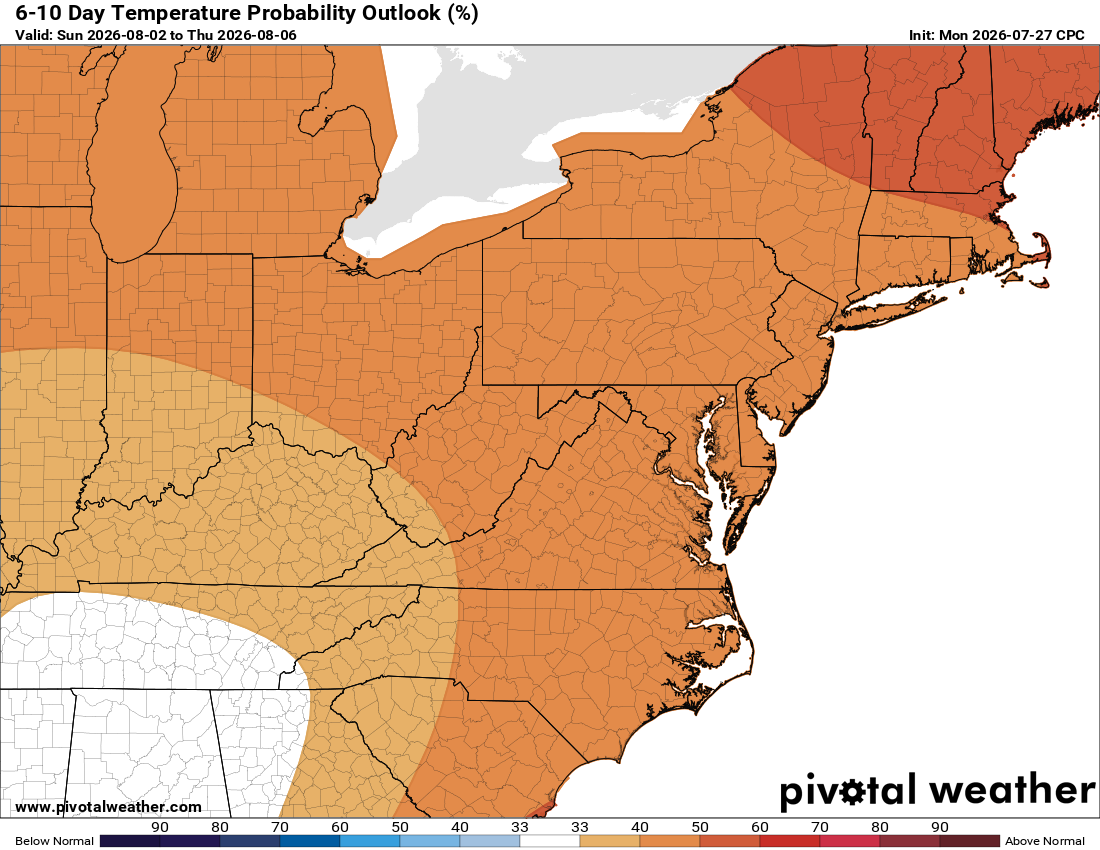
Temperatures trend a touch above normal heading into late next week, though that's not a lock yet. Rainfall in the longer range looks close to normal.

The forecast:

Saturday: Hi 81 🌦️20% Lo 63 – Slight chance of morning showers, becoming sunny in the afternoon
Sunday: Hi 85 🌀️ Lo 65 🌧️40% – Mostly sunny, chance of showers and storms evening into the overnight
Monday: Hi 88 🌦️40% Lo 68 🌧️70% – Chance of afternoon storms, continuing overnight with showers likely by early Tuesday
Tuesday: Hi 86 🌧️70% Lo 66 🌧️30% – Showers likely with possible thunderstorms, continuing into the evening
Wednesday: Hi 84 🌦️20% Lo 64 – Slight chance of afternoon storms, otherwise mostly sunny
Thursday: Hi 84 🌦️20% Lo 64 🌧️20% – Slight chance of showers and thunderstorms
Friday: Hi 87 🌦️20% Lo 68 – Slight chance of showers and thunderstorms, otherwise sunny

#loudoun #loudouncountyva #vawx #loudounweather #loudounva #virginiaweather

Please support Tree of Life Ministries, an important organization to me! https://www.tolministries.org
:

Check out weekend activities: https://summer.joyinnova.com
image.png


image.png

Loudoun County Weather Outlook for Friday, July 24, 2026

🌞 Cool Start to Friday
A chilly morning, with some backyard spots dropping to the mid fifties. Today warms into the low eighties with a bit more cloud cover, but still nice.

β˜€οΈ Saturday Staying Pleasant
Highs again in the low eighties with comfortable conditions.

🌦️ Sunday Turns More Humid
A southerly wind picks up, bringing increasing clouds and humidity, with a chance of an afternoon shower or storm.

β›ˆοΈ Unsettled Pattern Monday Into Tuesday
Highs reach the mid to upper eighties Monday with a slight chance of a storm. Better chances arrive Monday night into Tuesday, with some stronger storms possible.

🌀️ Midweek Improvement
Wednesday and Thursday return to mid and upper eighties, with only a low chance of a stray shower or storm each day.

πŸ“Š Looking Further Out
The long range trend favors near normal temperatures and near normal rainfall.

Have an awesome Friday and an excellent weekend!

The forecast:
Today: Hi 82 🌞 Lo 61 ☁️ – Mostly sunny with calm winds, becoming mostly cloudy overnight
Saturday: Hi 81 🌞 Lo 63 ☁️ – Mostly sunny with calm winds, partly cloudy overnight
Sunday: Hi 86 🌦️30% Lo 66 🌧️30% – Mostly sunny with a chance of showers and thunderstorms after 2pm, continuing into the evening
Monday: Hi 88 🌀️20% Lo 69 🌧️40% – Mostly sunny with a slight chance of afternoon storms, then a chance of showers and thunderstorms overnight
Tuesday: Hi 88 ☁️70% Lo 67 🌧️60% – Mostly cloudy with likely showers and possible thunderstorms throughout the day and evening
Wednesday: Hi 86 🌀️20% Lo 64 ☁️20% – Mostly sunny with a slight chance of showers and thunderstorms
Thursday: Hi 86 β˜€οΈ Lo 65 – Sunny

#loudoun #loudouncountyva #vawx #loudounweather #loudounva #virginiaweather

Please support Tree of Life Ministries, an important organization to me! https://www.tolministries.org

Loudoun County Weather Outlook for Thursday, July 23, 2026

πŸ”Ÿ Perfect Ten Thursday!

Today's a ten out of ten. Highs near 80 with low humidity, a treat for late July. Great day for the Loudoun County Fair or any outdoor plans. Check out https://summer.joyinnova.com for more to do this weekend.

πŸ“… Great Stretch Through the Weekend
Friday and Saturday bring low 80s and comfortable conditions, some of the nicest weather of the summer.

🌦️ Sunday Turns a Bit More Humid
Humidity creeps up with highs still in the low 80s. Isolated chance of an early shower, then another slight chance late in the day, around 20 percent.

πŸ₯΅ Heating Up Monday and Tuesday
Monday brings more humidity and highs near 90 with an isolated shower or storm possible. Tuesday has better odds for storms, highs back near 90 and muggy.

🌀️ Settling Into the Mid 80s
Temperatures ease into the mid 80s by midweek. Still a chance of a shower Wednesday. Today through Sunday is the best stretch of the summer.

The forecast:

Today: Hi 79 🌞 Lo 57 – Sunny skies, clear overnight
Friday: Hi 81 β›… Lo 62 ☁️ – Increasing clouds during the day, mostly cloudy overnight
Saturday: Hi 81 🌀️ Lo 63 🌧️20% – Mostly sunny, slight chance of showers late overnight
Sunday: Hi 83 🌦️20% Lo 65 🌧️30% – Slight chance of showers early morning and again late afternoon, chance of showers and thunderstorms mainly evening into overnight
Monday: Hi 87 🌦️20% Lo 69 🌧️40% – Slight chance of showers and thunderstorms late afternoon, chance of showers and thunderstorms mainly overnight
Tuesday: Hi 88 β›ˆοΈ60% Lo 67 🌧️60% – Showers and thunderstorms likely during the day and overnight
Wednesday: Hi 85 🌦️20% Lo 66 – Slight chance of showers and thunderstorms, mostly sunny

#loudoun #loudouncountyva #vawx #loudounweather #loudounva #virginiaweather

Please support Tree of Life Ministries, an important organization to me! https://www.tolministries.org

Facebook: https://facebook.com/loudounwx
Twitter: https://twitter.com/loudounwx
Instagram: https://www.instagram.com/loudounweather/
On the Web @ https://loudounweather.com
TikTok: https://www.tiktok.com/@loudounweather

image.png
image.png

image.png