Local weather. A little perspective.Loudoun County, VirginiaOfficial NWS alerts ↗
Loudoun County, Virginia

The local outlook

Forecasts, updates and a little local perspective.

Loudoun County Weather Outlook for Tuesday, August 13, 2024

The weather is just beautiful today! The high will be in the low 80s, and we continue with lower humidity! This is the sweetness of summer weather. 
Rain chances return Friday through Monday, but this will not be a washout. 
The extended now does show the temperatures staying near normal which has come down to the mid-80s as we get later into August! It also shows a continued chance for above average rainfall. This is a great way to end Summer. I have a strong feeling as we start September, we could see some heat return for a bit.  
The forecast:
Today: Hi 81 🌤️ Lo 60 🌙 – Mostly sunny with light winds, becoming mostly clear and calm tonight
Wednesday: Hi 84 ☀️ Lo 61 🌙 – Sunny and mostly clear with calm winds
Thursday: Hi 88 ☀️ Lo 64 🌙 – Sunny with calm winds, becoming partly cloudy at night
Friday: Hi 87 🌤️ ⛈️ 30%  Lo 69 ⛈️50% – Mostly sunny with a chance of showers an thunderstorms
Saturday: Hi 87 🌤️⛈️50% Lo 68 ⛈️40% – Mostly sunny with afternoon thunderstorms, continuing with a chance of showers overnight
Sunday: Hi 85 🌤️⛈️50% Lo 66 ⛈️30% – Mostly sunny with afternoon thunderstorms
Monday: Hi 85 🌤️⛈️40% Lo 65 – Mostly sunny with a chance of showers and thunderstorms
We do need the rain to continue weekly so we can keep the drought in check! It appears we could get some rain, so that is good! 
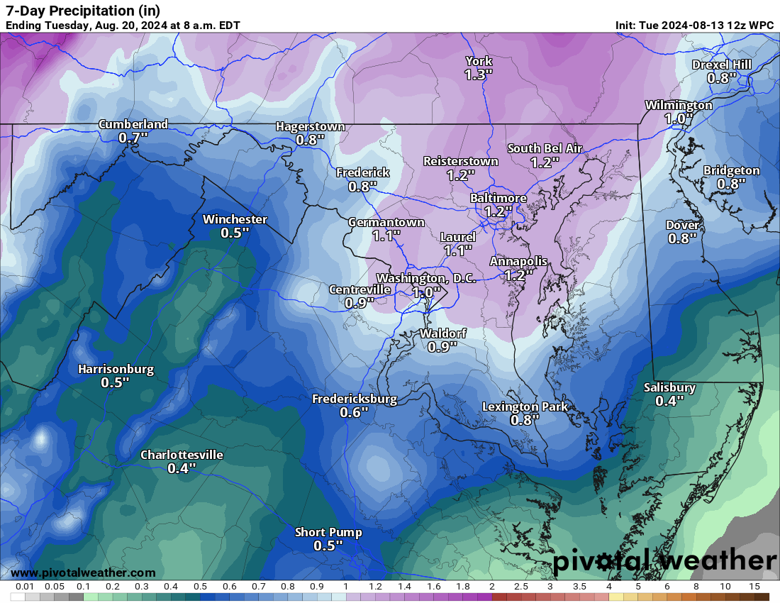
image.png

Loudoun County Weather Outlook for Monday, August 12, 2024

I just hope you get outside today and enjoy some of the best summer weather! 🙂
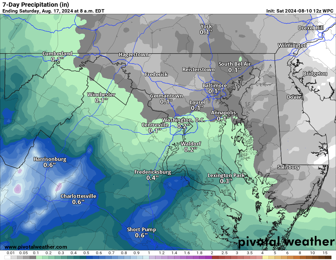
Sunny skies and comfortable nights with rain chances visiting in about a week!
The 7-day outlook for rain has that little bit arriving next Friday! We will need some more by then! 
The Forecast
Today: Hi 85 🌤️ Lo 62 🌙 – Mostly sunny with light northwest wind, becoming partly cloudy tonight
Sunday: Hi 82 🌤️ Lo 59 🌙 – Mostly sunny with a light northwest wind, becoming partly cloudy overnight
Monday: Hi 84 ☀️ Lo 61 🌙 – Sunny with a light west wind, becoming partly cloudy at night
Tuesday: Hi 81 🌤️ Lo 61 🌙 – Mostly sunny during the day, becoming mostly clear overnight
Wednesday: Hi 84 ☀️ Lo 63 🌙 – Sunny throughout the day, becoming partly cloudy overnight
Thursday: Hi 84 🌤️ Lo 63 🌙 30% – Mostly sunny with a slight chance of showers overnight
Friday: Hi 82 🌤️⛈️40% Lo 63 ⛈️  – Mostly sunny with a chance of showers and thunderstorms during the day, and showers overnight
#loudoun #loudouncountyva #vawx #loudounweather #loudounva #virginiaweather
Please support Tree of Life Ministries, an important organization to me! https://www.tolministries.org

Loudoun County Weather Outlook for Saturday, August 10, 2024

8/10/2024 – I just hope you get outside today and enjoy some of the best weather of the summer! 🙂
Sunny skies and comfortable nights with rain chances visiting in about a week!
The 7-day outlook for rain has that little bit arriving next Friday! We will need some more by then! 
The Forecast
Today: Hi 85 🌤️ Lo 62 🌙 – Mostly sunny with light northwest wind, becoming partly cloudy tonight
Sunday: Hi 82 🌤️ Lo 59 🌙 – Mostly sunny with a light northwest wind, becoming partly cloudy overnight
Monday: Hi 84 ☀️ Lo 61 🌙 – Sunny with a light west wind, becoming partly cloudy at night
Tuesday: Hi 81 🌤️ Lo 61 🌙 – Mostly sunny during the day, becoming mostly clear overnight
Wednesday: Hi 84 ☀️ Lo 63 🌙 – Sunny throughout the day, becoming partly cloudy overnight
Thursday: Hi 84 🌤️ Lo 63 🌙 30% – Mostly sunny with a slight chance of showers overnight
Friday: Hi 82 🌤️⛈️40% Lo 63 ⛈️  – Mostly sunny with a chance of showers and thunderstorms during the day, and showers overnight
image.png

Loudoun County Weather Outlook for Thursday, August 8, 2024

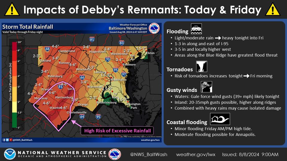
The Forecast and Debby Update – You can see in the attached from US National Weather Service Baltimore/Washington that the remaining rains, directly from Debby, are now in the 1.5 to 3-inch range for Loudoun. I agree with this as the storm is going to be picked up well with the trough, which will help bring cooler/dryer air this weekend and accelerate it northwards. The storm is now expected to be far enough west to keep that heavier swath of rain to the west as well. 1.5 to 3 inches of rain is great. Of note, there could still be training storms that happen in localized areas, and these could drop several inches of rain. Where/If these set up will be a radar watching and short-term outlook.
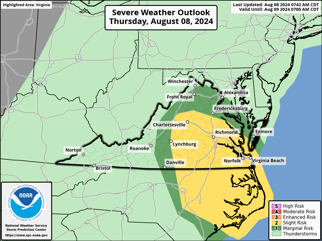
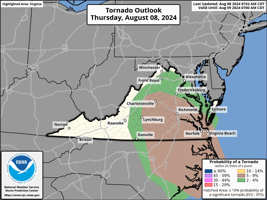
Severe threat: Although there is a risk of tornadoes, it is not that great. I've attached the outlook, and I'll be watching for updates later as the storm approaches. Storms could still produce gusty winds.
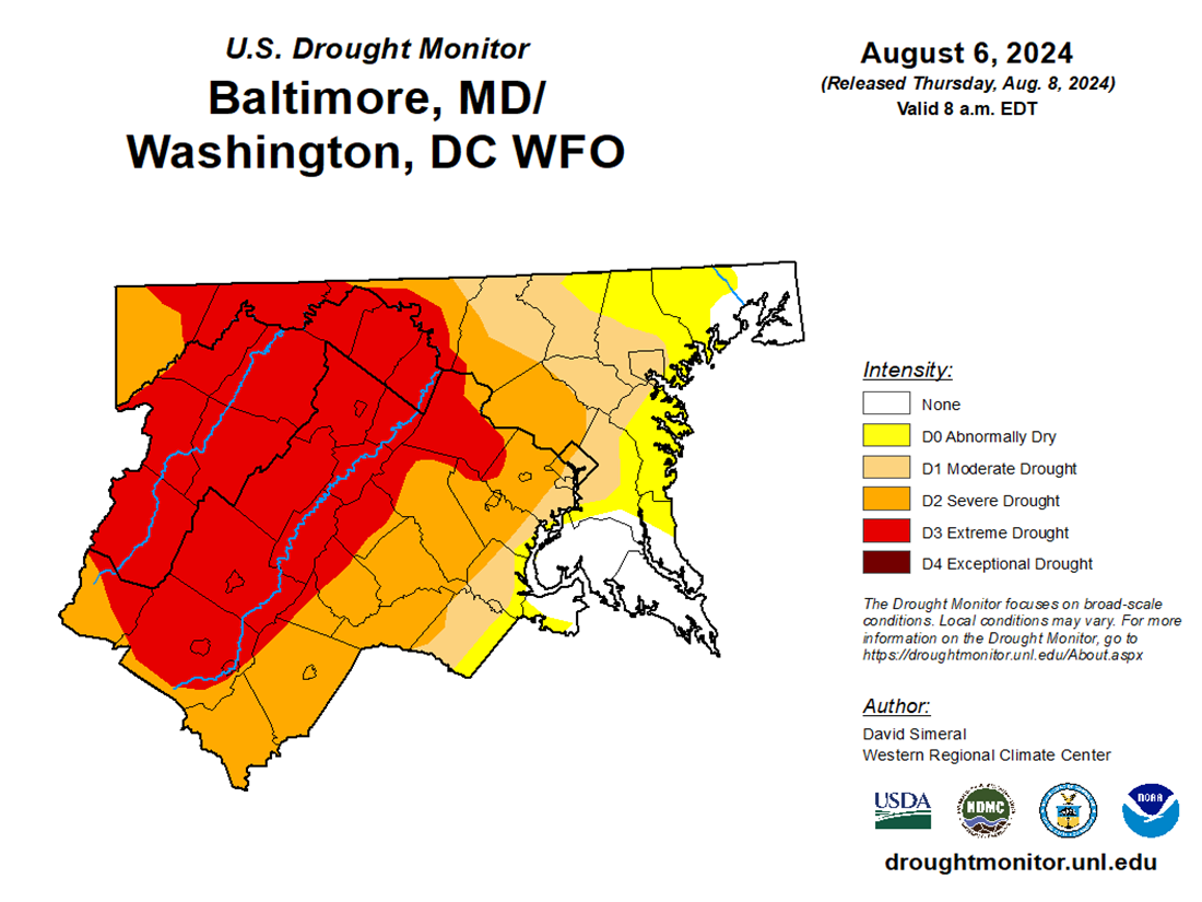
The weather turns so lovely after this, and we look dry from late Friday through next Wednesday. We will see what impacts the recent rain has on the drought, but we will remain in a drought. However, some locations will be dropped from the extreme and moderate drought. I attached the latest monitor that only counted rain through Tuesday morning.  
The  Forecast:
Today: Hi 78 ⛈️80% Lo 73 ⛈️90% – Showers and possibly a thunderstorm. Some storms could produce heavy rainfall with gusty winds.
Friday: Hi 81 ⛈️100% Lo 67 🌙40% – Showers and thunderstorms, heavy rainfall possible. Chance of showers and thunderstorms at night, becoming partly cloudy later.
Saturday: Hi 82 ☀️ Lo 61 🌙 – Sunny
Sunday: Hi 82 ☀️ Lo 59 🌙 – Sunny 
Monday: Hi 84 ☀️ Lo 62 🌤️ – Sunny
Tuesday: Hi 81 🌤️ Lo 62 🌤️ – Mostly sunny 
Wednesday: Hi 84 🌤️ Lo 63 🌤️ – Mostly sunny
3f56a4ec-4d57-468c-9c97-1f713ebf7ba6.png

image.png

image.png

image.png

Loudoun County Weather Outlook for Friday, August 2, 2024

IT IS HOT! A Heat Advisory kicks in at noon and ends at 8pm. The rain focus has been hard to pinpoint the last few days. I am NOT HAPPY with the trends being east of us but, we can get some prolific rainers where storms can form.

We have a marginal risk (1 out of 5) for a severe storm, and wind would be the main threat. There are some hints that it could be raised today and tomorrow. I will be watching.

There are signs that we will get back to normal temperatures later next week and a continued chance of above-average rain.

THERE IS A CHANCE that we could get some influence from the tropical system that will be impacting the southeast. I do not have much confidence for us, but anyone heading to the beaches in the Southeastern US from Virginia to Florida should be thinking of some non-beach things to do because this system is going to be a problem! From rain to rough seas, this system could be a problem. SO MUCH UNKNOWN for now, but I will be updating as we look at the system through the weekend.

The forecast:
Today: Hi 97 ⛈️60% Lo 72 ⛈️60% 🌡️ – 🥵 Scattered showers and thunderstorms likely, becoming more frequent after 3pm. Mostly sunny and hot, with heat index values up to 104.

Saturday: Hi 90 ⛈️70% Lo 70 ⛈️60% – Isolated showers in the morning, then showers and thunderstorms likely from late morning.

Sunday: Hi 88 ⛈️50% Lo 69 🌙30% – A chance of showers and thunderstorms, especially after 11am.

Monday: Hi 94 ☀️ Lo 69 🌙 – 🥵 Sunny and mostly clear.

Tuesday: Hi 91 🌤️ Lo 68 ⛈️30% – Mostly sunny during the day. A chance of showers and thunderstorms at night.

Wednesday: Hi 87 🌤️30% Lo 66 ⛈️30% – Mostly sunny with a chance of showers and thunderstorms throughout the day and night.

Thursday: Hi 86 🌤️30% Lo 66🌙 – Mostly sunny with a chance of showers.

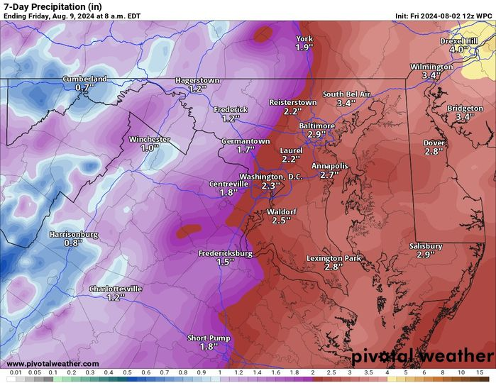
The total rain forecast for the next seven days is attached. You can note the downward trend from yesterday, but 1 to 2 inches is not bad! We can hope!

image.png