🌤️ Improving Friday
Northerly winds should gradually bring lower humidity with highs in the low 80s.
⛅ Really Nice Saturday
Saturday looks great with variable clouds around and highs in the upper 70s.
🌧️ Humidity and Rain Chances Return Sunday
Humidity increases with highs in the low 80s. Showers and thunderstorms become likely as a front approaches from the north.
🌧️ Cloudy and Unsettled Monday
The front should stall to our south with some showers possible and highs in the 70s.
🌧️ Much Cooler Tuesday
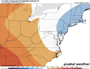
Disturbances moving along the stalled front could bring a better chance of rain Tuesday. Much cooler with highs only in the low to mid 60s.
🌧️ Chilly Wednesday
Very cool, with highs only around 60°F and more showers and periods of rain are possible.
🌧️ Staying Cool Thursday
Thursday highs only in the mid to upper 60s, with additional showers possible.
🌧️ How Much Rain?
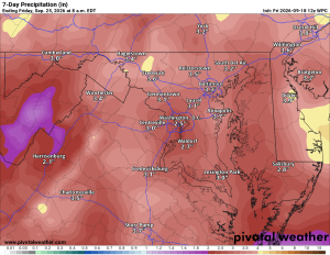
There is still plenty of uncertainty about exactly where the front stalls and whether each disturbance makes it far enough north to bring us rain, but guidance suggests 2 to 3 inches could be possible
We'll see how everything pans out, but right now a cooler and potentially much wetter week is looking possible.
The Forecast:
Friday: Hi 83 ⛅ Lo 59 ☁️
Patchy fog early, then partly sunny.
Saturday: Hi 77 ⛅ Lo 65 ☁️ – Partly sunny.
Sunday: Hi 82 🌧️70% Lo 65 🌧️70% – Showers likely with a possible thunderstorm.
Monday: Hi 74 🌧️50% Lo 60 🌧️60% – Chance of rain showers.
Tuesday: Hi 66 🌧️60% Lo 55 🌧️70% – Rain showers likely.
Wednesday: Hi 61 🌧️60% Lo 54 🌧️50% – Rain showers likely.
Thursday: Hi 66 🌧️40% Lo 56 🌧️ – Chance of rain showers.
#loudoun #loudouncountyva #vawx #loudounweather #loudounva #virginiaweather
Please support Tree of Life Ministries, an important organization to me!
Facebook: https://facebook.com/loudounwx
Twitter: https://twitter.com/loudounwx
Instagram: https://www.instagram.com/loudounweather/
On the Web @ https://loudounweather.com
Fall events in the area: https://fall.joyinnova.com