Local weather. A little perspective.Loudoun County, VirginiaOfficial NWS alerts ↗
Loudoun County, Virginia

Category: Uncategorized

Loudoun County Weather Outlook for Saturday, November 29, 2025

11/29/2025
❄️ Cold Saturday with a Chance of Flurries
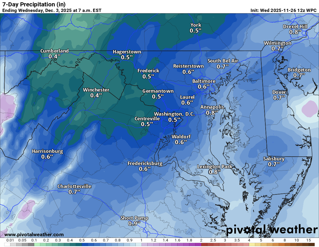
Temps stay chilly today around 40°F, but at least the winds have calmed down. A few snow showers could sneak in late tonight with a chance of some flakes or mixed showers into Sunday morning.

🌬️ Wintry Mix Possible Early Tuesday
Sunday stays cold with highs in the low to mid 40s. Monday will be similar, and by late Monday night into early Tuesday, a mix of snow and sleet possible before changing to mostly rain Tuesday afternoon.

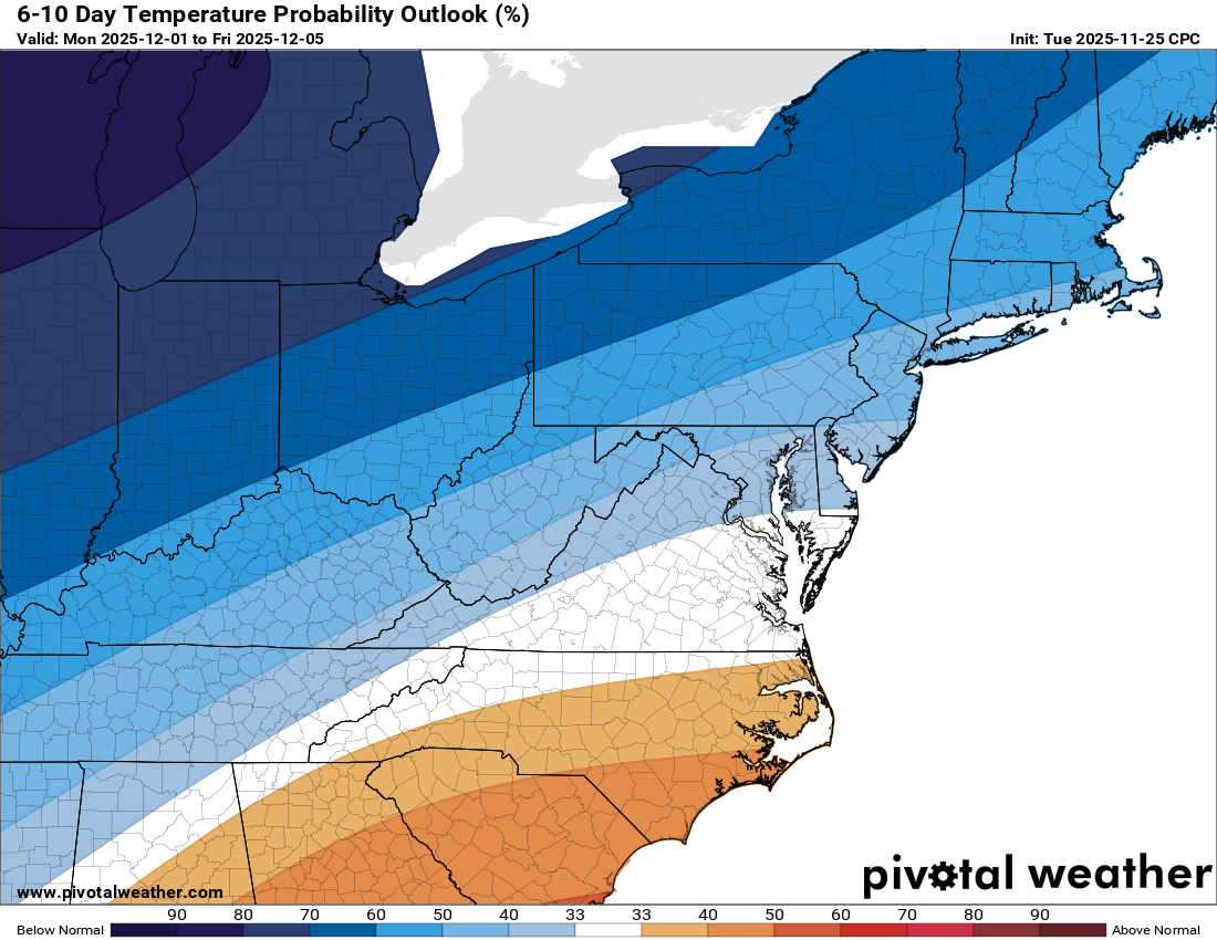
🥶 Staying Cold All Week
Highs hover near 40 or even upper 30s much of next week. Another system could bring wintry weather by next weekend, so something to watch.

🌨️ More Snow Chances in the Long Range
Several smaller systems may clip the area, and if the cold holds, snow chances are still on the table into mid-December.

The forecast:
Today: Hi 41 ☀️ Lo 30 🌙 – Sunny with calm winds, becoming cloudy overnight

Sunday: Hi 46 ❄️🌦️40% Lo 28 🌙 – Chance of snow early transitioning to rain by late morning, then partly cloudy at night

Monday: Hi 41 ☀️ Lo 28 ❄️🌧️50% – Mostly sunny during the day, with a chance of snow mixing with rain overnight

Tuesday: Hi 38 ❄️🌧️80% Lo 26 🌧️❄️30% – Rain and snow during the day, becoming all rain by afternoon, with a chance of mixed precipitation in the evening

Wednesday: Hi 41 ☀️ Lo 25 🌙 – Sunny and cold

Thursday: Hi 42 ⛅ Lo 22 🌙 – Partly sunny and chilly

Friday: Hi 37 ☁️ Lo 23 ❄️ – Mostly cloudy with a chance of snow overnight
#loudoun #loudouncountyva #vawx #loudounweather #loudounva #virginiaweather

Please support Tree of Life Ministries, an important organization to me! https://www.tolministries.org

Facebook: https://facebook.com/loudounwx
Twitter: https://twitter.com/loudounwx
Instagram: https://www.instagram.com/loudounweather/
On the Web @ https://loudounweather.com
TikTok: https://www.tiktok.com/@loudounweather
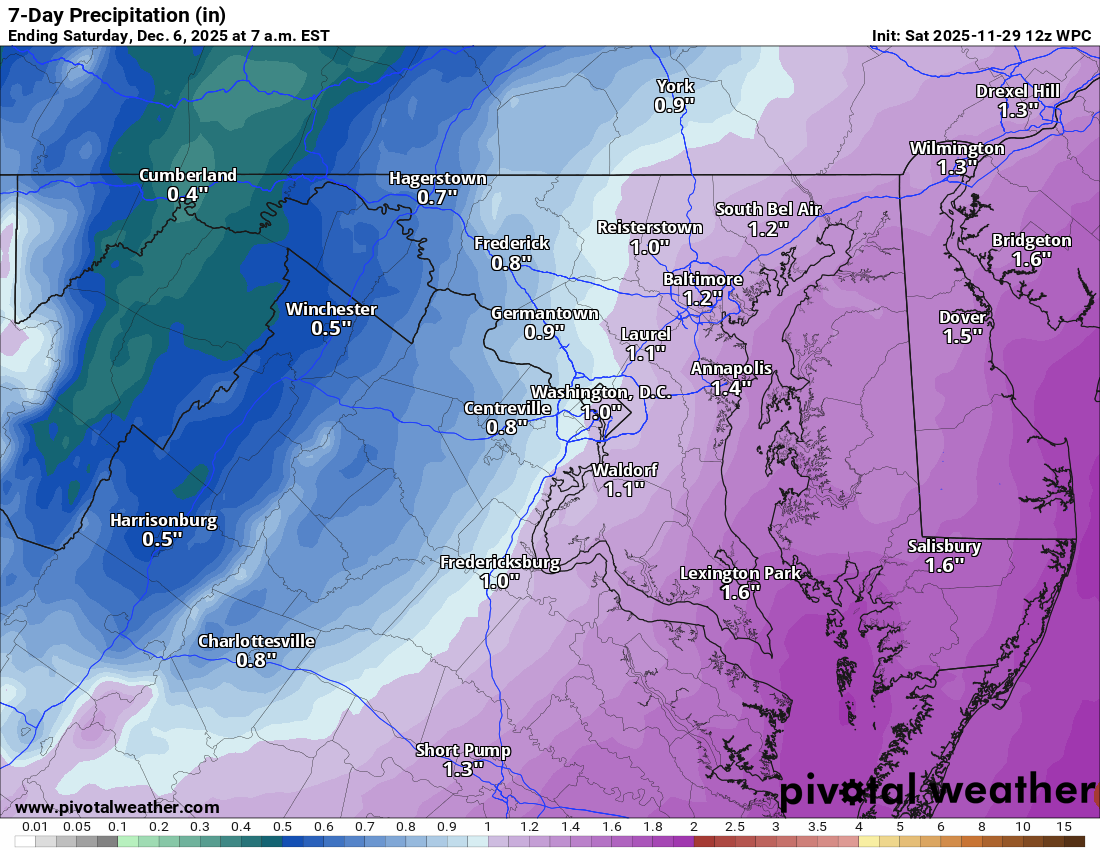
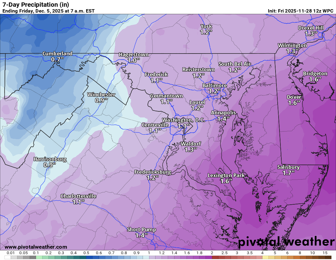
image.png

Loudoun County Weather Outlook for Friday, November 28, 2025

11/28/2025
❄️ Cold and Windy Black Friday
Bundle up if you're heading out for post-Thanksgiving shopping. Highs stay in the upper 30s with gusty winds making it feel even colder. Tonight drops into the low to mid-20s—make sure hoses and spigots are winterized.

🌬️ Cold Saturday, Light Snow Possible Late
Saturday stays chilly with highs near 40, but winds ease through the day. Late Saturday night into early Sunday could bring a bit of light snow before changing to rain.

🌧️ Chilly Start to the Week
Monday looks cold with highs in the low to mid-40s. Another chance for light snow Monday night mixing with rain by Tuesday morning. It doesn’t look like a big deal, just some cold rain.

🌾 Drought Continues
We’re still in a severe drought, so any moisture helps. The cold pattern looks to hold through next week

The forecast:
Today: Hi 39 🌞 Lo 24 🌙 – Scattered morning flurries, becoming sunny and breezy

Saturday: Hi 41 ☀️ Lo 28 ❄️30% – Sunny during the day, turning mostly cloudy overnight with a chance of snow late

Sunday: Hi 44 ❄️🌧️60% Lo 28 ☁️ – Rain and snow likely in the morning, changing to rain; mostly cloudy overnight

Monday: Hi 40 🌞 Lo 27 ❄️30% – Mostly sunny during the day, chance of snow late at night

Tuesday: Hi 37 ❄️🌧️50% Lo 25 🌧️30% – Chance of rain and snow and sleet switching to cold rain

Wednesday: Hi 40 🌞 Lo 23 🌙 – Mostly sunny and cold, clear and chilly overnight

Thursday: Hi 43 ⛅ Lo 25 🌙 – Partly sunny and cold

#loudoun #loudouncountyva #vawx #loudounweather #loudounva #virginiaweather

Please support Tree of Life Ministries, an important organization to me! https://www.tolministries.org

image.png

Loudoun County Weather Outlook for Wednesday, November 26, 2025

11/26/2025
🍂 Quiet Today Before the Cold Arrives
A pleasant Wednesday with highs near 70 and a southerly breeze. Winds will shift to the northwest later, ushering in colder air tonight.

🦃 Blustery Thanksgiving Ahead
Thanksgiving will be mostly cloudy and chilly with highs in the low 40s. Gusty winds will make it feel more like the low 30s.

🌬️ Cold and Breezy Friday
Skies clear a bit but it stays cold and windy with highs only in the upper 30s.

❄️ Weekend Chill
Saturday stays chilly around 40 with lighter winds. Sunday brings a slight warmup into the 40s with a slight chance of rain, which may have some sleet or snow mixed in.

🌧️ Watching Next Week’s Storm
More showers possible Monday. A southern storm system could impact us by Tuesday or Wednesday with potential wintry weather. The American model hints at snow.

🥶 Below Normal Temps Stick Around
Expect a colder pattern with more wintry chances on the way. Have a great Wednesday and a Happy Thanksgiving!

The forecast:
Today: Hi 68 🌦️30% Lo 35 ☁️ – Patchy morning fog with scattered late morning showers, becoming mostly sunny with increasing clouds at night

Thanksgiving Day: Hi 42 ⛅ Lo 27 🌙 – Partly sunny and breezy, then mostly clear overnight

Friday: Hi 39 ☀️ Lo 24 🌙 – Sunny and breezy during the day, remaining clear overnight

Saturday: Hi 41 ☀️ Lo 27 ☁️ – Sunny skies giving way to increasing clouds at night

Sunday: Hi 45 ⛅ Lo 35 🌧️50% – Mostly cloudy during the day, with rain developing overnight

Monday: Hi 45 ☁️ Lo 31 🌧️50% – Mostly cloudy with scattered showers continuing into the night

Tuesday: Hi 39 ☁️ Lo 33 🌧️❄️ – Mostly cloudy with showers possible during the day, mixing with snow overnight

#loudoun #loudouncountyva #vawx #loudounweather #loudounva #virginiaweather

Please support Tree of Life Ministries, an important organization to me! https://www.tolministries.org


image.png
image.png

Loudoun County Weather Outlook for Monday, November 24, 2025

11/24/2025
🌤️ Nicer Start to the Week
Today brings calmer weather with highs in the mid-50s and much lighter winds, so it’ll feel better than yesterday’s breeze.

🌧️ Showers Return Tuesday
Clouds increase tonight with lows in the upper 30s. Tuesday brings a decent shot at afternoon showers that linger into the night but won’t bring much rain.

☁️ Mostly Cloudy Midweek
Wednesday stays mostly cloudy with a spotty shower possible. Winds pick up late and turn northwest, setting us up for a chill.

🦃 Chilly Thanksgiving
Thanksgiving highs only reach the mid-40s with even colder air arriving Friday. Black Friday looks breezy and cold, possibly stuck in the 30s.

🌡️ Weekend Warm-Up Coming
We’ll moderate into the mid-40s this weekend, and a more noticeable warm-up looks likely by Sunday and into early next week. Another rain chance may arrive by midweek.

The forecast:
Today: Hi 56 🌤️ Lo 39 ☁️ – Mostly sunny during the day, becoming mostly cloudy overnight

Tuesday: Hi 53 🌧️90% Lo 48 🌧️50% – Rain likely in the afternoon, with a chance of showers continuing through the evening

Wednesday: Hi 68 🌦️20% Lo 35 🌙 – Partly sunny with a slight chance of rain, then clearing overnight

Thanksgiving Day: Hi 44 🌤️ Lo 28 🌙 – Mostly sunny and cold, clear and chilly overnight

Friday: Hi 39 🌞 Lo 24 🌙 – Sunny and cold, clear and cold at night

Saturday: Hi 41 🌤️ Lo 29 ☁️ – Mostly sunny through the day, becoming mostly cloudy late

Sunday: Hi 46 🌦️30% Lo 38 ☁️ – Mostly cloudy with a chance of afternoon rain, staying mostly cloudy overnight

#loudoun #loudouncountyva #vawx #loudounweather #loudounva #virginiaweather

Please support Tree of Life Ministries, an important organization to me! https://www.tolministries.org


image.png

Loudoun County Weather Outlook for Saturday, November 22, 2025

11/22/2025
🌥️ Cloudy Start with Clearing Skies
A foggy and damp start to the day, but skies should break up a bit this afternoon with highs reaching the mid 50s.

🌞 Brighter Tomorrow
Sunday looks sunnier and a touch warmer with highs in the upper 50s. A great day to get outside!

☀️ Mild Start to the Week
Monday and most of Tuesday stay dry with highs in the mid to upper 50s. Clouds build late Tuesday with showers possible into the night and lingering early Wednesday.

🌡️ Midweek Warm-Up Before a Chill
Wednesday brings a nice bump in temps into the mid 60s before a front cools things off. Highs drop to around 50 Thursday and then down to the low to mid 40s Friday.

📉 Cool Snap Doesn’t Last
After a cold shot next weekend, long-range models hint at a rebound in temps with readings near or even above normal. The expected deep cold is shifting west. We still could be cold at times, and it does not rule out some interesting weather, but prolonged cold does not seem likely at this point. It is far off, and, thus, speculation!

The forecast:
Today: Hi 55 🌦️50% Lo 37 🌙 – Mostly cloudy with scattered morning showers, becoming partly cloudy overnight

Sunday: Hi 59 🌤️ Lo 35 🌙 – Mostly sunny during the day and clear overnight

Monday: Hi 55 ☀️ Lo 38 🌙 – Sunny and mostly clear at night

Tuesday: Hi 55 🌦️40% Lo 48 🌧️50% – Mostly cloudy with a chance of afternoon rain, continuing into the night

Wednesday: Hi 64 🌦️30% Lo 39 ☁️ – Partly sunny with a slight chance of morning rain, becoming mostly cloudy

Thanksgiving Day: Hi 49 🌤️ Lo 30 🌙 – Mostly sunny during the day and partly cloudy overnight

Friday: Hi 44 🌤️ Lo 26 🌙 – Colder with mostly sunny skied and cold at night

#loudoun #loudouncountyva #vawx #loudounweather #loudounva #virginiaweather

Please support Tree of Life Ministries, an important organization to me! https://www.tolministries.org