Local weather. A little perspective.Loudoun County, VirginiaOfficial NWS alerts β†—
Loudoun County, Virginia

Category: Uncategorized

Loudoun County Weather Outlook for Thursday, January 9, 2025

1/9/2025 – Cold and Blustery out there! Highs in the 20s and winds which will make it feel like the teens all day. Winds could gust to 40 mph.
Cold tonight and tomorrow. Tomorrow night we will get light snow that could drop as much as 1 inch of snow.
Not as cold Sunday and Monday. We could see 40 degrees on Monday! Colder air returns Tuesday and sunny and dry conditions remain.
The next window of storminess possibilities is around the 20th. We may warm enough to see rain or a mix. Too far off to be specific.
The forecast:
Today: Hi 28 🌬️ Lo 14 πŸŒ™ – Sunny and blustery with strong northwest winds.

Friday: Hi 31 ☁️ Lo 22 🌨️70% – Increasing clouds during the day. Light snow is likely at night.

Saturday: Hi 35 🌀️20% Lo 19 πŸŒ™ – A slight chance of morning snow, then mostly sunny and breezy.

Sunday: Hi 33 β˜€οΈ Lo 14 πŸŒ™ – Sunny and cool during the day. Mostly clear skies at night.

Monday: Hi 38 🌀️ Lo 19 πŸŒ™ – Mostly sunny and mild.

Tuesday: Hi 29 🌀️ Lo 14 πŸŒ™ – Mostly sunny and chilly during the day. Clear and cold at night.

Wednesday: Hi 25 🌀️ Lo 10- Mostly sunny and cold.

#loudoun #loudouncountyva #vawx #loudounweather #loudounva #virginiaweather

Please support Tree of Life Ministries, an important organization to me! https://www.tolministries.org

Loudoun County Weather Outlook for Wednesday, January 8, 2025

1/8/2025 – It will be really cold the next several days and then signs of some “warmer” air in the longer range, though still below normal. Some nuisance snow overnight Friday, and then dry conditions look to prevail.
The biggest note here are windchills in the single digits this morning, around zero tomorrow, and Friday morning.
Snow showers overnight Friday could coat the area or give us up to an inch.. if lucky, 2 inches (or unlucky if you hate snow)
The long range looks cold and dry but slightly warmer than this week.

The forecast:
Today: Hi 28 🌀️ Lo 16 πŸŒ™ – Mostly sunny and breezy, becoming partly cloudy with gusty winds at night.

Thursday: Hi 26 β˜€οΈ Lo 15 πŸŒ™ – Sunny and blustery with wind chills near zero. Mostly clear and gusty overnight.

Friday: Hi 30 🌀️ Lo 22 ❄️80% – Partly sunny during the day. Light snow likely overnight.

Saturday: Hi 34 🌨️30% Lo 20 πŸŒ™ – A chance of morning snow, then partly sunny.

Sunday: Hi 33 β˜€οΈ Lo 14 πŸŒ™ – Sunny and cold.

Monday: Hi 36 🌀️ Lo 22 πŸŒ™ – Partly sunny and not as cold

Tuesday: Hi 32 🌀️ Lo 20 – Mostly sunny skies.

#loudoun #loudouncountyva #vawx #loudounweather #loudounva #virginiaweather

Please support Tree of Life Ministries, an important organization to me! https://www.tolministries.org

Loudoun County Weather Outlook for Tuesday, January 7, 2025

1/7/2025 – Cold, Blustery day and more snow in the forecast:
We will see a windy and cold day. Cold will be the story throughout the week, as this is the coldest stretch of winter.
The next story is that snow is now likely on Friday night. Early indications are a light event (1 to 3 inches), and details on the exact amounts are still TBD. I did a 5-minute outlook on YouTube if interested, but I use many words to say the same thing with some model reading as well. https://youtu.be/hvHqlVDLIkk

Cold will dominate the extended but not as cold as the next several days as we head into next week.
The forecast:
Today: Hi 31 🌀️ Lo 18 πŸŒ™ – Sunny and blustery with strong northwest winds and gusts up to 40 mph, becoming partly cloudy with diminishing winds at night.

Wednesday: Hi 28 🌀️ Lo 13 πŸŒ™ – Mostly sunny with brisk northwest winds and gusts up to 29 mph, partly cloudy overnight with wind chills as low as -3Β°F.

Thursday: Hi 26 β˜€οΈ Lo 15 πŸŒ™ – Sunny and blustery with strong northwest winds and gusts up to 34 mph, becoming mostly clear and breezy at night.

Friday: Hi 31 🌀️ Lo 23 🌨️60% – Mostly sunny, becoming cloudy at night with snow likely after midnight.

Saturday: Hi 33 🌨️40% Lo 23 πŸŒ™ – A chance of snow in the morning, then mostly cloudy, becoming partly cloudy at night.

Sunday: Hi 34 🌀️ Lo 19 πŸŒ™ – Mostly sunny during the day, with partly cloudy skies overnight.

Monday: Hi 35 🌀️ Lo 21 – Mostly sunny.

#loudoun #loudouncountyva #vawx #loudounweather #loudounva #virginiaweather

Please support Tree of Life Ministries, an important organization to me! https://www.tolministries.org

Loudoun County Weather Outlook for Monday, January 6, 2025

1/6/2025 – Happy Snowy Monday! Snow will be light to moderate at times. Another 3 to 5 inches today.
Cold weather will DOMINATE the longer range.
I am still watching this weekend, but confidence is now FADING that we will see much of anything. This trend would have to show big changes on the next few runs for me to get interested in it again!

I show the extended over on YouTube if interested. After today it is just showing colder conditions will persist!

The forecast:
Today: Hi 27 ❄️100% Lo 19 🌨️80% – Snow throughout the day with total accumulation of 3 to 5 inches. Snow tapers off before 10pm with additional 1 to 2 inches possible this evening. Gusty northwest winds up to 32 mph.

Tuesday: Hi 31 🌀️ Lo 17 ☁️ – Mostly sunny, cold, and blustery.

Wednesday: Hi 28 🌀️ Lo 12 πŸŒ™ – Mostly sunny with a breezy and very cold conditions.

Thursday: Hi 25 β˜€οΈ Lo 16 πŸŒ™ – Sunny and blustery and very cold.

Friday: Hi 30 🌀️ Lo 21 ☁️ – Mostly sunny. Watching storminess to the south.

Saturday: Hi 32 πŸŒ₯️ Lo 20 πŸŒ™ – Partly sunny

Sunday: Hi 33 🌀️ Lo 22 πŸŒ™ – Mostly sunny.


#loudoun #loudouncountyva #vawx #loudounweather #loudounva #virginiaweather

Please support Tree of Life Ministries, an important organization to me! https://www.tolministries.org

Loudoun County Weather Outlook for Friday, January 3, 2025

1/3/3024 – Snow today! Significant Snow Sunday Night and Monday!
Today we should see some mixed rain/snow showers change to a potential burst of snow that could whiten the ground. Winds will increase later today! That will set up a cold weekend. Snow should start late Sunday evening and become heavy overnight!

Preliminary outlook would be 4 to 8 inches possible with some seeing as much as 10+ inches if model trends continue! Mixing is still possible so that would impact snow totals!

Cold week to follow!

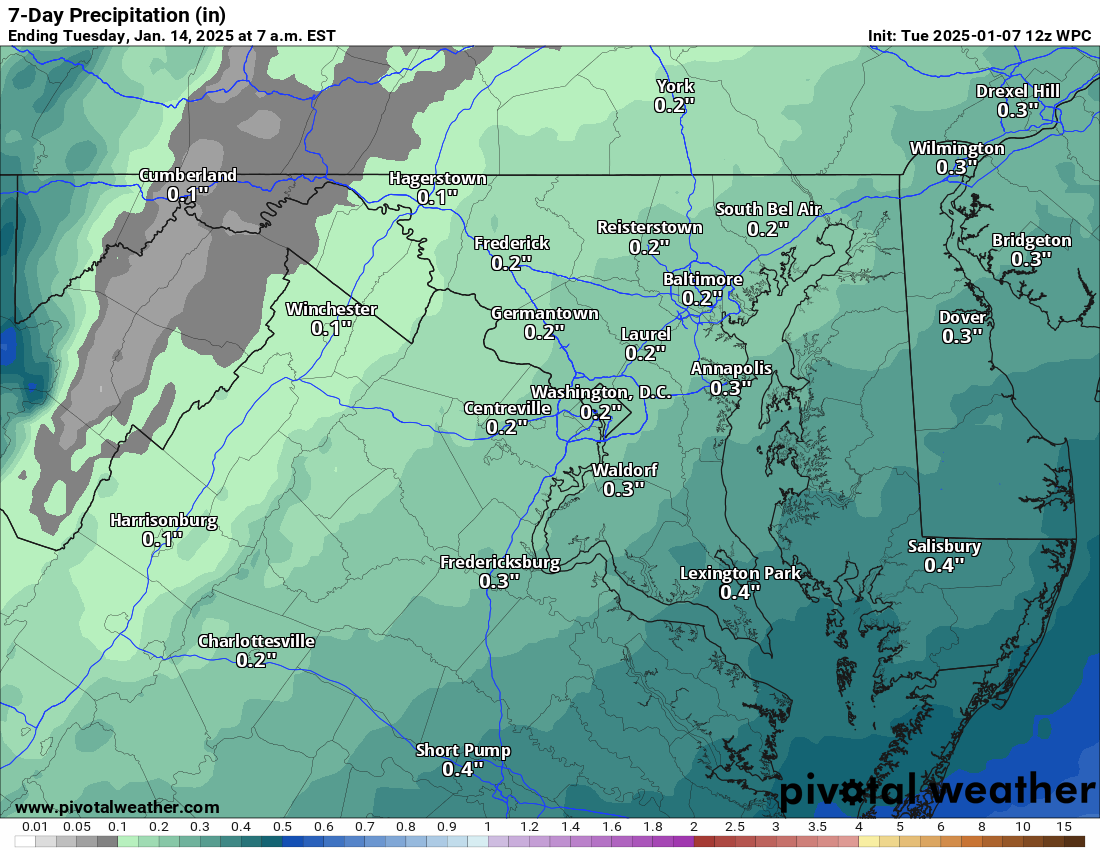
Attached is the Liquid Equivalent output for precipitation this week!

Full video showing models and output was released earlier! –> https://youtu.be/zOZdUL3JtQA?si=VmCU4IS8BhUrgnNW

The forecast:
Today: Hi 40 πŸŒ§οΈπŸŒ¨οΈβ„οΈ80% Lo 23 πŸŒ¨οΈπŸŒ™30% – Rain showers mixing with and changing to snow after 2pm, becoming partly cloudy by evening. Gusty winds throughout the day and night.

Saturday: Hi 30 🌀️ Lo 19 πŸŒ™ – Mostly sunny and blustery during the day, with mostly clear skies at night.

Sunday: Hi 33 🌀️ Lo 24 ❄️100% – Mostly sunny early, with snow, potentially heavy at times, overnight.

Monday: Hi 30 ❄️90% Lo 20 β„οΈπŸŒ™30% – Snow, possibly mixed with freezing rain and sleet early, transitioning to all snow, then mostly cloudy by night.

Tuesday: Hi 30 β˜€οΈ Lo 17 πŸŒ™ – Sunny and Cold!

Wednesday: Hi 29 🌀️ Lo 14 πŸŒ™ – Sunny and Cold

Thursday: Hi 25 🌀️ Lo 10 πŸŒ™ – Sunny and Cold

#loudoun #loudouncountyva #vawx #loudounweather #loudounva #virginiaweather

Please support Tree of Life Ministries, an important organization to me! https://www.tolministries.org