Local weather. A little perspective.Loudoun County, VirginiaOfficial NWS alerts ↗
Loudoun County, Virginia

Author: admin

Loudoun County Weather Outlook for Sunday, June 29, 2025

6/29/2025
⛈️ Stormy and Steamy Start to the Week
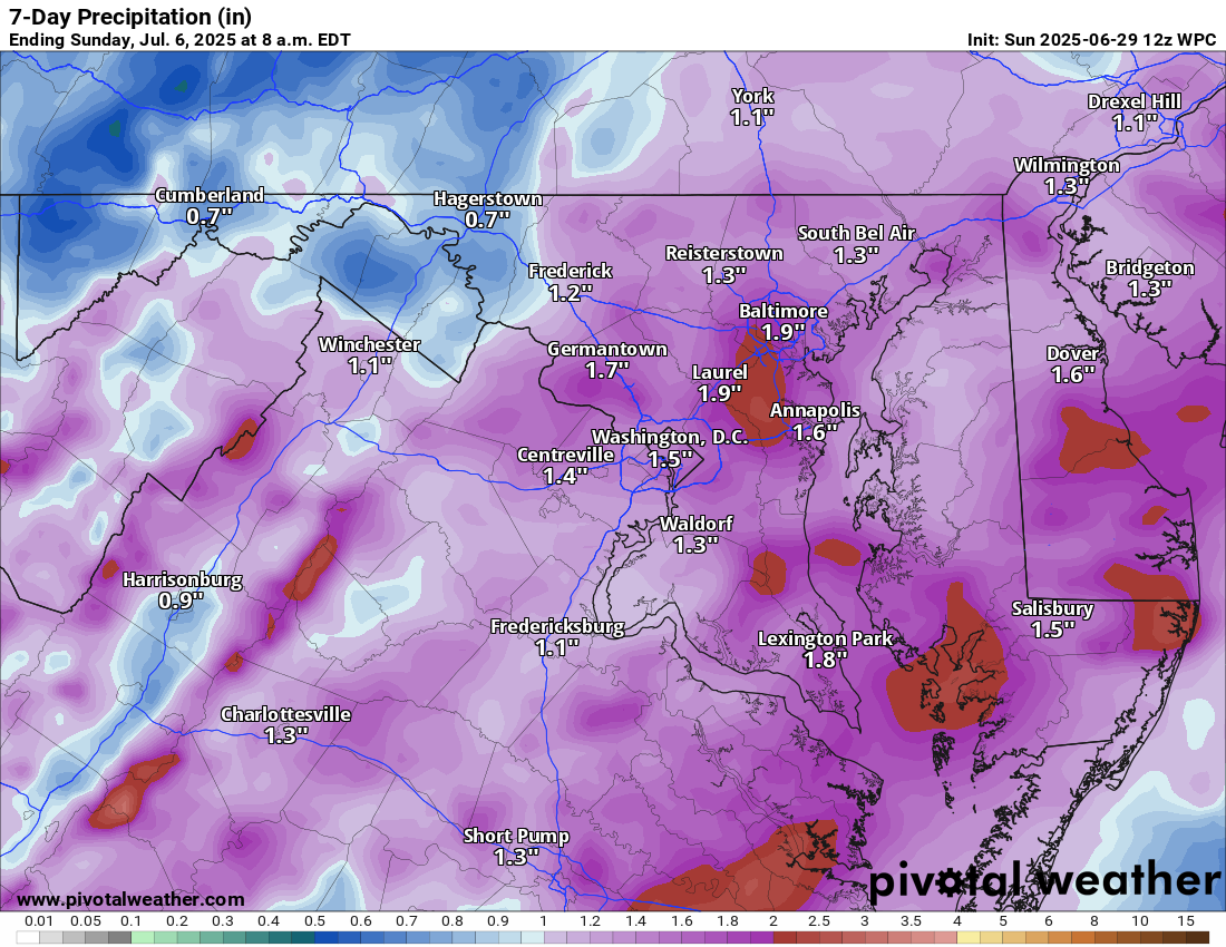
We're in for another hot and humid day with highs near 90°F, but it will feel closer to 100°F. Much like yesterday, expect afternoon and evening showers and thunderstorms—some could turn strong to severe with locally heavy rainfall.

🌩️ More Storms Monday into Tuesday
Monday brings another round of heat, storms, and potential severe weather, with highs again around 90°F. On Tuesday, showers and storms are likely throughout the day and into the evening, keeping things wet and unsettled.

🌤️ Beautiful Midweek Break
Relief arrives midweek! Wednesday and Thursday bring lower humidity, highs in the mid to upper 80s, and pleasant nights in the 60s.

🎆 Fantastic 4th of July Friday!
Friday, the 4th of July, looks very nice with highs in the mid to upper 80s, low humidity, and great conditions for fireworks displays in the evening!

🔥 Turning Hot Again Saturday
By Saturday, heat and humidity start creeping back, with highs approaching 90°F. A summer sizzle returns for the weekend!

The forecast:
Today: Hi 89 ⛈️60% Lo 71 🌧️30% – Mostly sunny with likely afternoon thunderstorms

Monday: Hi 89 ⛈️80% Lo 73 ⛈️80% – Showers and thunderstorms likely

Tuesday: Hi 88 ⛈️80% Lo 68 🌧️80% – Thunderstorms likely

Wednesday: Hi 85 ☀️ Lo 66 🌙 – Sunny and nice

Thursday: Hi 87 ☀️ Lo 65 🌙 – Sunny skies

Independence Day: Hi 86 ☀️ Lo 66 🌙 – Sunny

Saturday: Hi 90 🌤️🥵 Lo 67 🌙 – Mostly sunny and hotter

#loudoun #loudouncountyva #vawx #loudounweather #loudounva #virginiaweather

Please support Tree of Life Ministries, an important organization to me! https://www.tolministries.org


Please support Tree of Life Ministries, an important organization to me! https://www.tolministries.org

Loudoun County Weather Outlook for Saturday, June 28, 2025

6/28/2025
🔥 Heat & Humidity Return This Weekend
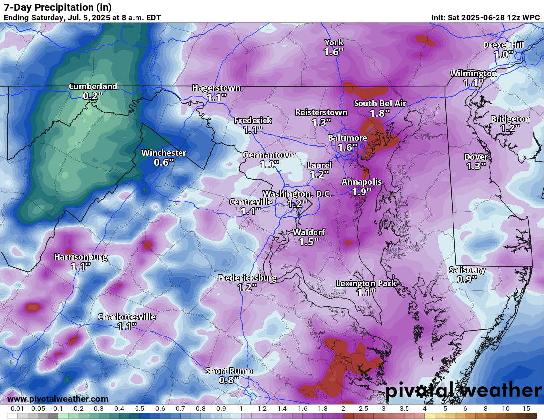
Highs around 90 and heat index values nearing 100°F today and tomorrow with scattered storms. Some could be strong.

⛈️ Storm Chances Increase Early Week
Monday and Tuesday bring a better shot at scattered showers and storms, with highs remaining near 90°F and plenty of humidity to go around. There’s a low-end risk for strong to severe storms

🌤️ Relief on the Horizon Midweek
By late Tuesday into Wednesday, humidity takes a dive. Wednesday through Friday look warm (mid to upper 80s), but noticeably more comfortable. While a stray shower can’t be ruled out, most of the holiday stretch looks dry and pleasant.

🎆🧨🎇Independence Day Looking Great!
So far, the 4th of July forecast is shaping up beautifully—warm, lower humidity, and dry. Enjoy it, because next weekend looks to turn hotter again!

The forecast:
Today: Hi 90 🌦️30% Lo 71 🌧️30% – Mostly cloudy early with a chance of afternoon showers and thunderstorms

Sunday: Hi 89 🌦️30% Lo 71 🌧️30% – Sunny with some afternoon/evening storms possible

Monday: Hi 90 🌦️ 60% Lo 73 🌧️60% – Mostly sunny turning to likely showers and possible thunderstorms

Tuesday: Hi 87 ⛅70% Lo 67 🌧️60% – Partly sunny with scattered storms

Wednesday: Hi 87 ☀️ Lo 68 ☁️ – Clear skies during the day

Thursday: Hi 89 🌤️ Lo 67 🌙 – Mostly sunny and continued mild overnight.

Independence Day: Hi 86 ☀️ Lo 62 🌙 – Sunny and pleasant

#loudoun #loudouncountyva #vawx #loudounweather #loudounva #virginiaweather

Please support Tree of Life Ministries, an important organization to me! https://www.tolministries.org


Please support Tree of Life Ministries, an important organization to me! https://www.tolministries.org

Loudoun County Weather Outlook for Friday, June 27, 2025

6/27/2025 –
🌫️ Damp and Much Cooler Start to the Weekend
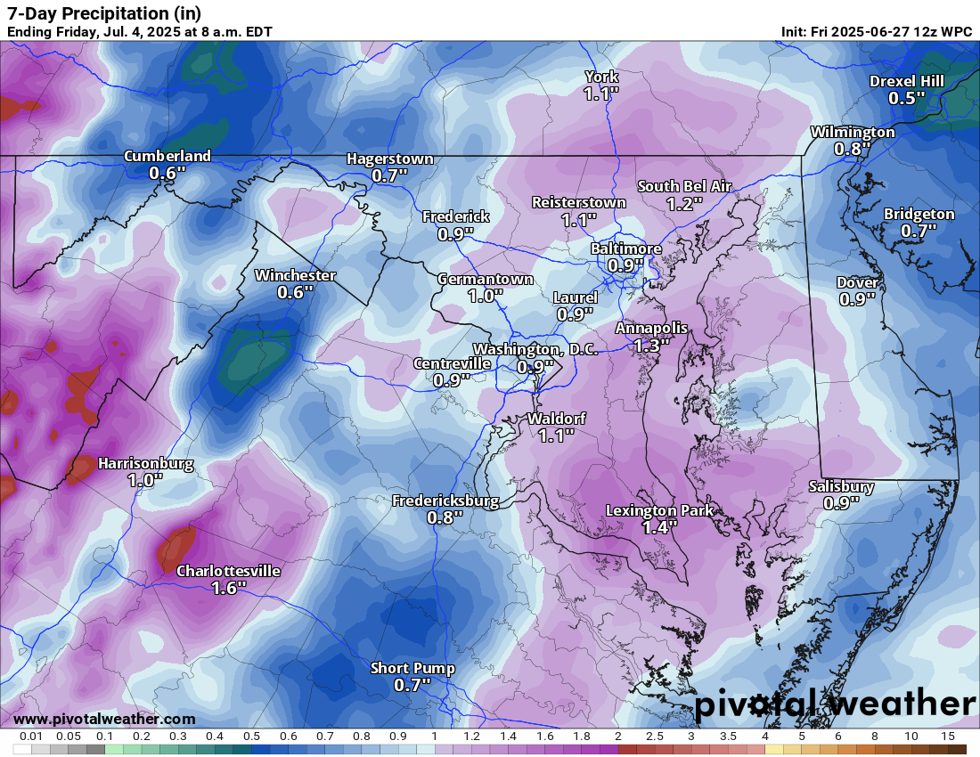
Easterly winds off the ocean are bringing in drizzle, fog, and a damp feel to the day. Showers and storms are likely later this evening. Some may contain locally heavy rain.

🌞 Foggy Start, Then Steamy Saturday
Saturday will turn sunny, but it will be very humid. Highs will reach near 90°F, with heat index values near 100°F. Scattered showers and thunderstorms are likely in the afternoon, with a few potentially strong to severe.

🔥 Hot and Humid Sunday
Highs will be in the low 90s, with heat index values near 100°F. An afternoon shower or storm is possible.

⛈️ Stormy Pattern Early Next Week
Monday and Tuesday bring highs in the low 90s, along with good chances of afternoon showers and storms. Relief arrives midweek.

🌤️ Turning More Comfortable Late Week
By Thursday and Friday, lower humidity with temps in the upper 80s.

The forecast:
Today: Hi 77 ⛈️70% Lo 70 🌧️40% – Showers and some thunderstorms likely this afternoon into the evening with heavy downpours possible

Saturday: Hi 91 🌦️60% Lo 70 🌧️60% – Partly sunny withafternoon showers and storms

Sunday: Hi 89 🌦️30% Lo 71 🌧️30% – Mostly sunny with isolated afternoon storms,

Monday: Hi 91 ⛈️60% Lo 71 🌧️60% – Sunny start with scattered afternoon thunderstorms

Tuesday: Hi 88 🌦️60% Lo 69 🌧️60% – Partly sunny and unsettled, with showers and storms possible late in the day and early night. Will watch for severe weather.

Wednesday: Hi 88 ☀️ Lo 66 🌙 – Warm and sunny, with lower humidity.

Thursday: Hi 88 ☀️ Lo 66 🌙 – Sunny

#loudoun #loudouncountyva #vawx #loudounweather #loudounva #virginiaweather

Please support Tree of Life Ministries, an important organization to me! https://www.tolministries.org


Please support Tree of Life Ministries, an important organization to me! https://www.tolministries.org

Loudoun County Weather Outlook for Thursday, June 26, 2025

6/26/2025
🌡️ Hot and Humid Thursday with Storms Likely
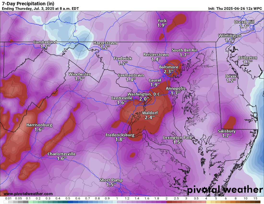
Another steamy day with highs in the low 90s and plenty of humidity. Showers and thunderstorms are likely late today, and some could be strong to severe.

⛈️ Cooler Friday, But Still Stormy
Friday temperatures will only be around 80°F, but the chance for showers and thunderstorms continues, and some could still be strong.

🌦️ Unsettled Weekend into Early Next Week
From Saturday through Tuesday, we’re stuck in a hot and humid pattern with daily chances of showers and storms. Highs will stay in the upper 80s to low 90s, and the humidity will make it feel even hotter.

🌤️ Relief by Wednesday
Finally, by midweek, we’ll clear out! Wednesday looks much nicer with highs in the mid-80s and noticeably lower humidity.

The forecast:
Today: Hi 92 🌦️60% Lo 71 🌧️60% – 🥵 Mostly sunny with scattered showers and thunderstorms before 4 PM, then showers and storms likely in the late afternoon

Tonight: Hi — Lo 71 🌧️60% – Showers and thunderstorms likely before 2 AM, then scattered showers overnight

Friday: Hi 80 🌧️70% Lo 70 🌧️60% – Much cooler with Showers and thunderstorms

Saturday: Hi 90 🌦️60% Lo 71 🌧️60% – Mostly sunny with showers and storms likely after 2 PM

Sunday: Hi 88 🌦️60% Lo 70 🌧️60% – Mostly sunny with showers and thunderstorms likely after 2 PM

Monday: Hi 88 🌦️60% Lo 72 🌧️60% – Partly sunny with showers and storms likely after 2 PM

Tuesday: Hi 88 🌧️60% Lo 69 🌧️60% – Partly sunny with showers and storms likely

Wednesday: Hi 87 ☀️ Lo 67 🌙 – Sunny and clear night

#loudoun #loudouncountyva #vawx #loudounweather #loudounva #virginiaweather

Please support Tree of Life Ministries, an important organization to me! https://www.tolministries.org


Please support Tree of Life Ministries, an important organization to me! https://www.tolministries.org

Loudoun County Weather Outlook for Wednesday, June 25, 2025

6/25/2025
🥵 Heat Advisory Continues – Still Feeling Like 105-110°!
While the Extreme Heat Warning has been dropped, a Heat Advisory remains in effect. Highs will again surge into the 90s, with feels-like temps around 107°. It's hot, humid, and uncomfortable out there!

⛈️ Storm Relief This Evening?
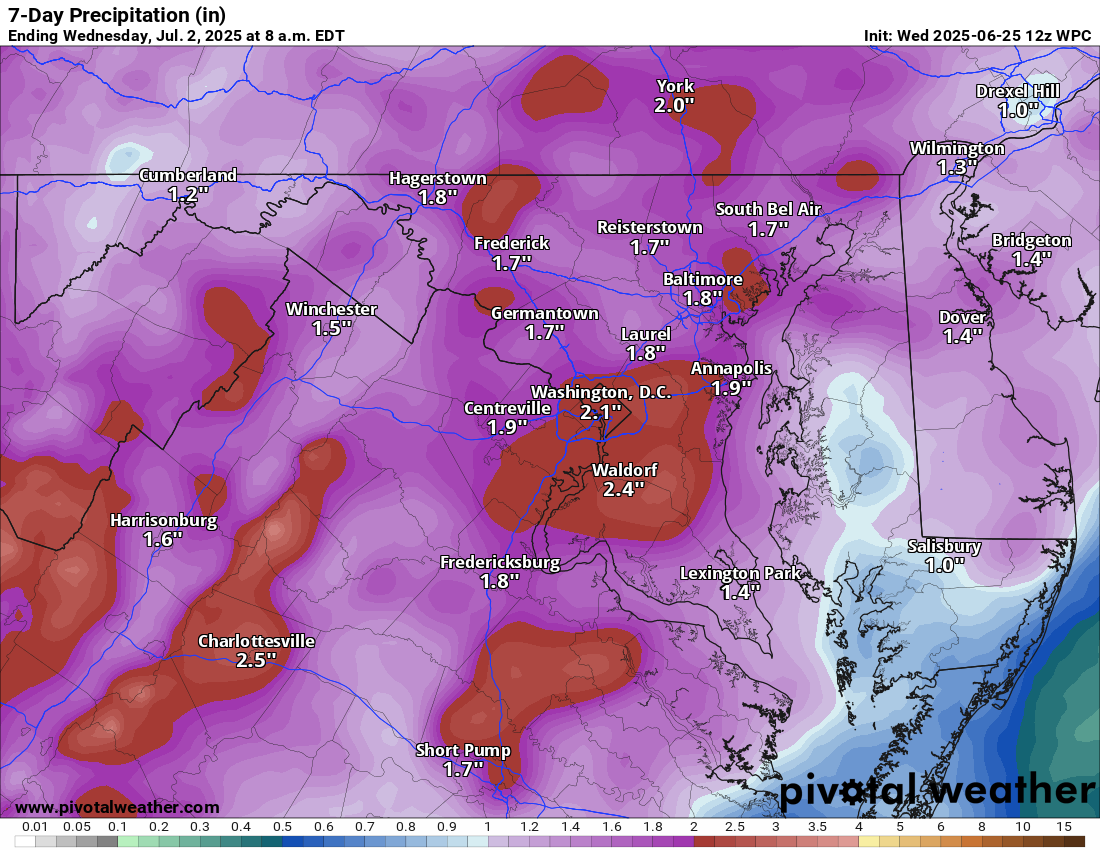
A good chance of late-day and evening showers & thunderstorms could bring some much-needed relief. However, humidity stays high through Thursday, even as another round of storms is possible.
💨 Marginal risk for severe storms, with localized flooding possible

🌡️ Slight Break Friday
Temps cool down slightly Friday with highs in the low to mid 80s

🌞 Near 90° Through Early Next Week
Starting Saturday, we’re locked into a near-90° pattern through at least Tuesday, with daily chances of showers and storms.

Cooler by the 4th?
A front should arrive midweek, knocking temps down to the 80s for Independence Day 🎆.

The forecast:
Today: Hi 95 🥵🌦️30% Lo 74 🌧️30% – Hot and humid with scattered afternoon storms

Thursday: Hi 93 🥵🌦️70% Lo 71 🌧️60% – Isolated morning showers, then storms likely later, heavy rain possible overnight

Friday: Hi 83 🌧️60% Lo 71 🌧️60% – Mostly cloudy with showers and thunderstorms likely

Saturday: Hi 90 🌦️60% Lo 72 🌧️60% – Partly sunny with showers and storms likely

Sunday: Hi 89 ⛅50% Lo 71 🌧️30% – Mostly sunny with a chance of storms

Monday: Hi 90 🌦️60% Lo 72 🌧️60% – Partly sunny with showers and thunderstorms

Tuesday: Hi 90 🌦️60% Lo 72 🌧️ – Partly sunny with showers and thunderstorms

#loudoun #loudouncountyva #vawx #loudounweather #loudounva #virginiaweather

Please support Tree of Life Ministries, an important organization to me! https://www.tolministries.org


Please support Tree of Life Ministries, an important organization to me! https://www.tolministries.org