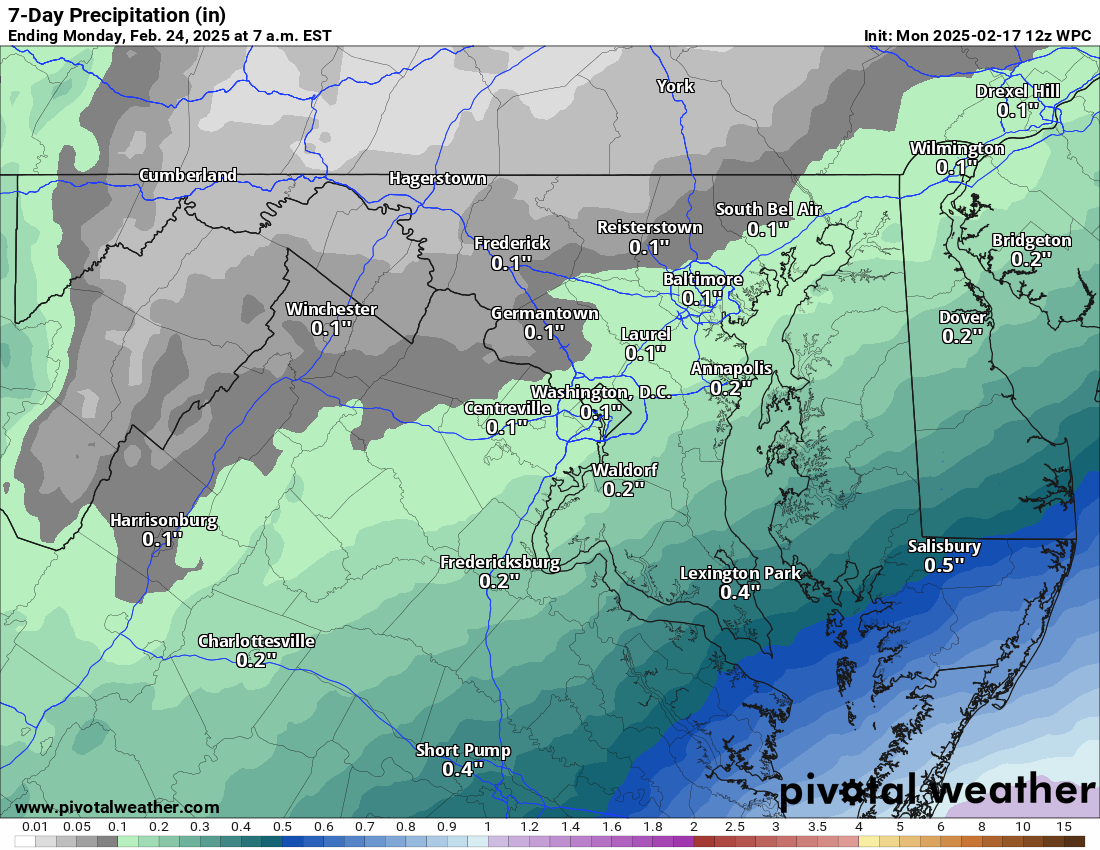
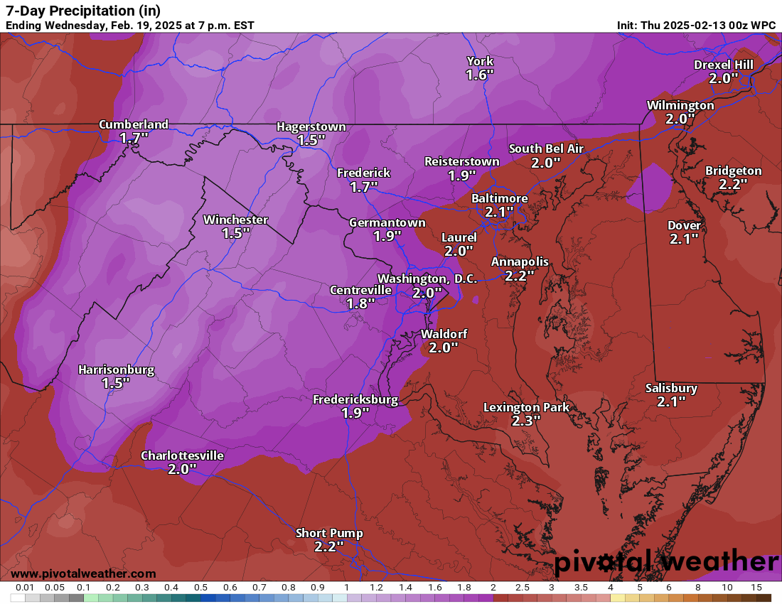
2/17/2025 – Cold and wintry feeling.. but just some snow possible on Wednesday. Wind advisory through midday. Overall, a boring week of weather. Cold and boring! 🙁
The low that was expected Wednesday was shunted to the south by the strong low that caused our wind and a miss on phasing/linking with northern energy. That miss has allowed the storm to go south and east of us! Now we are left with a cold week and a waste of cold air at that! I am still sorry that I was so excited so early, but the models were in agreement on a big snow last Friday. It has been a long time since we missed a system that ended up being south of us!
The more extended range shows a return to normal temperatures and dry as well. The chances of more wintry weather is starting to diminish. We may see a few small systems next week that could cause a little snow, but not much support for big winter storms.
Today: Hi 37 🌤️ Lo 20 🌙 – Scattered morning flurries, then mostly sunny and windy with gusts up to 47 mph, becoming mostly clear and calmer overnight
Tuesday: Hi 34 🌤️ Lo 17 🌙 – Mostly sunny with breezy conditions, becoming partly cloudy overnight
Wednesday: Hi 25 🌨️50% Lo 18 🌨️50% – Mostly cloudy with a chance of snow throughout the day and night
Thursday: Hi 28 🌨️40% Lo 19 🌙 – A chance of morning snow, then mostly cloudy, becoming partly cloudy overnight
Friday: Hi 35 ☀️ Lo 20 🌙 – Sunny and mostly clear
Saturday: Hi 38 🌤️ Lo 24 🌙 – Mostly sunny, becoming partly cloudy overnight
Sunday: Hi 43 🌤️ Lo 29 🌙 – Mostly sunny
#loudoun #loudouncountyva #vawx #loudounweather #loudounva #virginiaweather
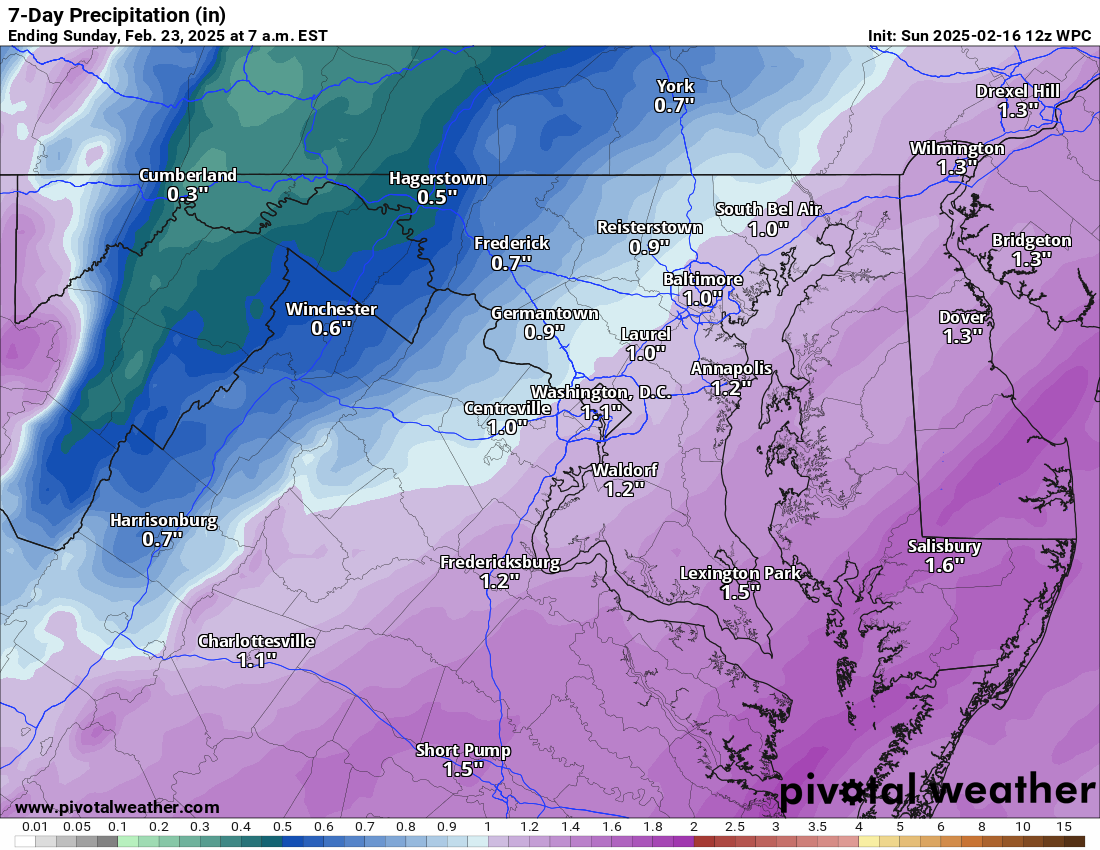
2/16/2025 – A very windy afternoon has prompted a High Wind Warning as the wind could gust to 60 mph. There are some showers and storms along the front, and they could also bring strong winds! The truly damaging winds should end this evening, but winds gusting into the 40s could continue through the first half of tomorrow!
We will get cold tonight, tomorrow, and Tuesday.
THEN – My attention is on Wednesday! This storm will likely NOT be as big of a deal for us as I once believed. Some factors could bring snow to the area, and it does have the potential to become more robust than what models are showing, but, as of now, a fluffy 2 to 5 inches seems possible. I know this is a far cry from what I have been sharing for the last 2 days, and I am sorry! I definitely was sold too early because of the unanimous model agreement, but the ensembles (a run of many different variations of the model) did say that I should be more cautious! And I did not listen! 🙁 I am SO SORRY for the over-excitement!
Colder conditions should stick around into next weekend and then I am watching for when the pattern may turn milder. Snow chances after Wednesday may be done for the season.. but we will have to examine that more soon.
Today: Hi 54 🌦️70% Lo 27 🌙 – Showers likely before 3pm, then partly sunny and windy with gusts up to 60 mph.
Washington's Birthday: Hi 36 🌤️ Lo 21 🌙 – Mostly sunny and breezy with gusts up to 46 mph.
Tuesday: Hi 33 🌤️ Lo 18 🌙 – Mostly sunny with a northwest breeze.
Wednesday: Hi 25 🌨️60% Lo 19 🌨️70% – Snow likely in the afternoon
Thursday: Hi 28 🌨️40% Lo 18 🌙 – A chance of snow before 1pm, then partly sunny and blustery.
Friday: Hi 35 ☀️ Lo 19 🌙 – Sunny during the day, with a partly cloudy night.
Saturday: Hi 36 🌤️ Lo 20 🌙 – Partly sunny throughout the day.
#loudoun #loudouncountyva #vawx #loudounweather #loudounva #virginiaweather
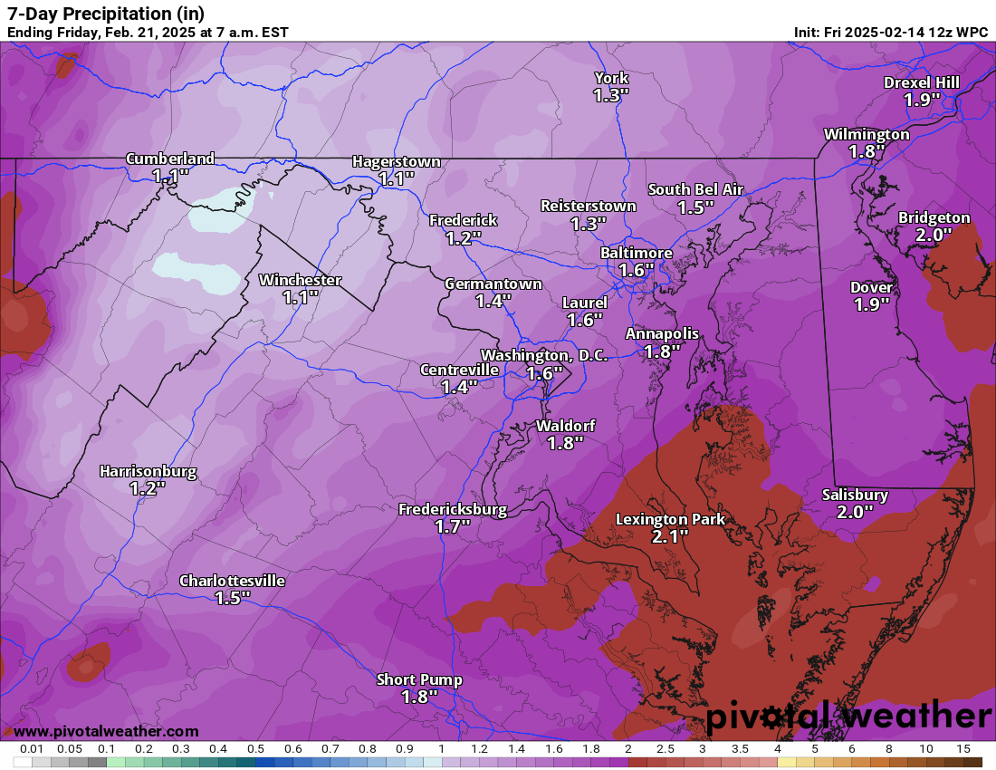
2/14/2025 – Colder today and breezy. Rain tomorrow (maybe a little mix at the start). Warmer, wet, and mild Sunday. Much colder next week! A big snow is possible later next week.
We will be windy today an feel the colder temps. Winds will die down through the day. After a cold night, we could have a mix of sleet and rain tomorrow. Warmer conditions will return Sunday before the front moves through, but it will be windy. Temps will be much colder next week. My snow-watching eyes are very much thinking that snow is coming in the middle of the week and there is the potential for a big snowstorm. BUT, this is so far off you cannot be sure that it will happen, that the big snow will be in our area, and it always has chances to change. The chance of snow continues to gain confidence.. it is the amounts and impact that remain unknown!
Today: Hi 38 ☀️ Lo 26 ☁️ – Sunny with northwest winds and gusts up to 21 mph, becoming mostly cloudy overnight with light winds shifting southeast
Saturday: Hi 36 🌨️100% Lo 32 🌧️100% – Snow and sleet changing to rain in the afternoon, continuing as rain overnight with gusty south winds
Sunday: Hi 57 🌧️90% Lo 28 ☁️🌙 – Rain with gusty south winds shifting west, becoming partly cloudy overnight
Washington's Birthday: Hi 35 🌤️ Lo 19 🌙 – Mostly sunny and cold with a clear night
Tuesday: Hi 32 🌤️ Lo 18 ☁️ – Mostly sunny, becoming mostly cloudy overnight
Wednesday: Hi 31 🌨️30% Lo 19 🌨️50% – Mostly cloudy with a chance of snow during the day and a higher chance of snow overnight
Thursday: Hi 30 🌨️50% Lo 20 🌨️50% – Mostly cloudy with a chance of snow
#loudoun #loudouncountyva #vawx #loudounweather #loudounva #virginiaweather
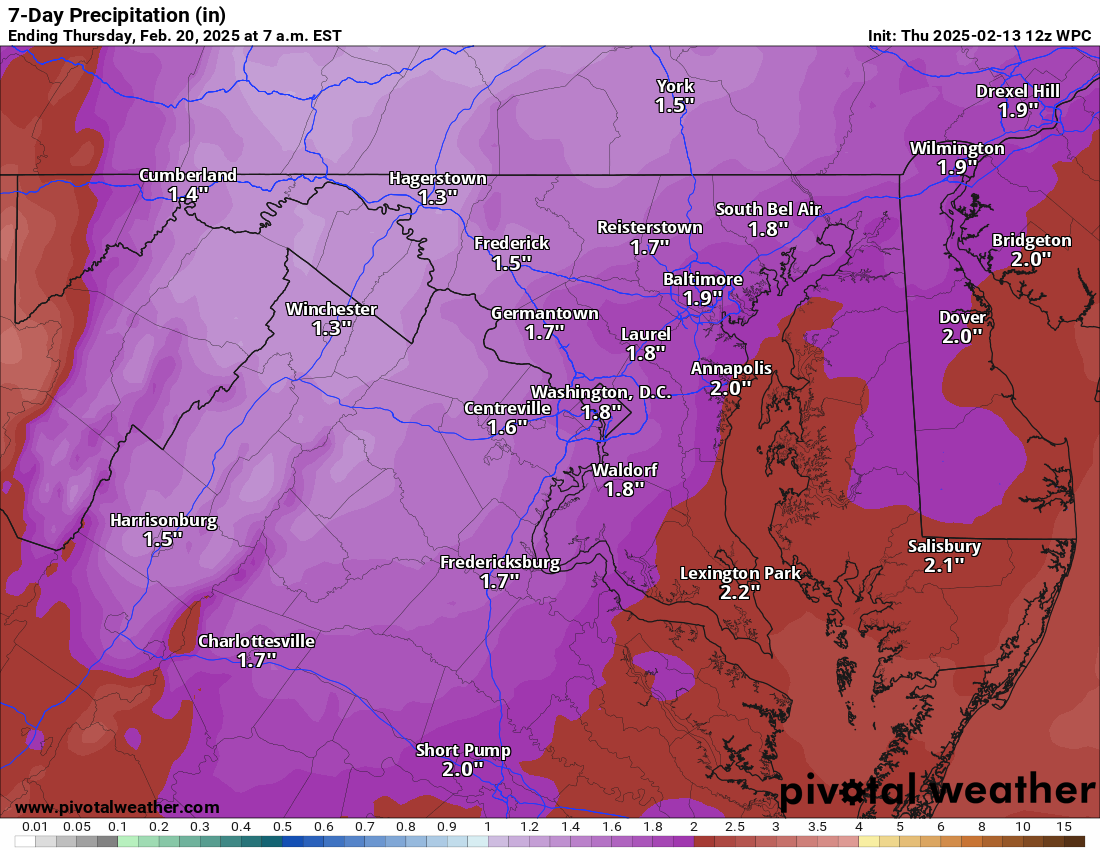
2/13/2025 – A pretty mild day ahead, but a wet weekend! We will see colder and windy conditions tomorrow that could help bring a mixture of rain, sleet, and snow Saturday before it turns to all rain. Sunday looks wet early, but dryer through the day and turning windy!
We turn windy and colder Monday and this MAY set the stage for more snow mid-week, but the details are not certain yet!
After a colder period, I do see signs of warmer conditions towards the end of the month!
Today: Hi 50 🌤️ Lo 25 🌙 – Areas of fog before noon, then mostly sunny and breezy with gusty west winds. Clear and blustery overnight.
Friday: Hi 37 ☀️ Lo 26 ☁️ – Sunny with a northwest breeze. Increasing clouds overnight with calm winds.
Saturday: Hi 42 🌨️🌧️100% Lo 35 🌧️100% – A slight chance of snow early, then rain and snow in the afternoon before changing to all rain. Rain continues overnight.
Sunday: Hi 55 🌧️100% Lo 23 🌙 – Rain, mainly in the morning, then clearing with breezy conditions overnight.
Washington's Birthday: Hi 32 ☀️ Lo 18 🌙 – Sunny and cold with mostly clear skies overnight.
Tuesday: Hi 33 🌤️ Lo 20 ☁️ – Mostly sunny, becoming mostly cloudy overnight.
Wednesday: Hi 32 🌨️40% Lo 25 🌨️ – A chance of snow with partly sunny skies.
#loudoun #loudouncountyva #vawx #loudounweather #loudounva #virginiaweather
2/12/2025 – Rain will be moving in this evening, with some sleet and pockets of freezing rain at the start. Rain overnight. Tomorrow will be milder, but it's turning colder on Friday. Saturday will be cold, with some mixing possible before some good rains. We could see 60 degrees on Sunday! Then it will be MUCH colder on Monday. There is another chance of snow in the middle of next week!
Overall, the forecast was not too bad. Southwestern Loudoun and a pocket of the area in middle Loudoun saw under 3 inches. Most everyone else saw between 3 and 4 inches, with some 5 and 6 inch snow well east and far southeastern areas. I give myself a B+. I should have done 3 to 5 inches and much more restrictive on the area that could see 5 and 6 inch snows, and I went with my gut! Not bad! Only slight improvements to get into the A grades!
Today: Hi 33 🌧️❄️80% Lo 32 🌧️100% – Rain, freezing rain, and sleet this afternoon, then rain, snow, and sleet changing to all rain tonight. Little or no ice accumulation expected.
Thursday: Hi 🌧️54 ⛅60% Lo 22 🌙 – Rain likely early, then becoming mostly sunny and breezy.
Friday: Hi 36 ☀️ Lo 28 🌙 – Sunny and chilly.
Saturday: Hi 40 🌧️❄️100% Lo 36 🌧️100% – Rain and snow possible in the morning, then rain throughout the day and night.
Sunday: Hi 55 🌧️100% Lo 23 🌙 – Rainy, then clearing and becoming blustery overnight.
Washington's Birthday: Hi 32 ☀️ Lo 18 🌙 – Sunny but cold.
Tuesday: Hi 33 🌤️ Lo 19 ☁️ – Mostly sunny during the day, becoming mostly cloudy at night.
Wednesday: Hi 32 🌨️ – A chance of snow with mostly cloudy skies.
#loudoun #loudouncountyva #vawx #loudounweather #loudounva #virginiaweather