Local weather. A little perspective.Loudoun County, VirginiaOfficial NWS alerts β†—
Loudoun County, Virginia

The local outlook

Forecasts, updates and a little local perspective.

Loudoun County Weather Outlook for Tuesday, December 2, 2025

12/2/2025
🌧️ Cold Rainy Tuesday
A wintry start this morning with sleet and freezing rain has turned to a chilly rain. Temps stay stuck in the 30s through the day with showers lingering into the evening.

🌬️ Chilly
Wednesday and Thursday will see highs around 40. Cold air drops temps fast on Thursday night with lows plunging into the teens.

🌨️ Watching Friday Night Snow
Friday stays cold with highs near freezing. A slight chance of snow arrives Friday night into early Saturday, though it remains uncertain. Keep an eye on the forecast.

🌑️ Chilly Weekend Ahead
Saturday reaches the mid 40s and Sunday stays around 40. Monday looks colder with highs only in the low to mid 30s.

❄️ Snow Chances Early Next Week
Colder air sticks around, and we’re watching for another shot at snow next week if the moisture lines up.

The forecast:
Today: Hi 40 🌧️100% Lo 24 πŸŒ™ – Rain through early afternoon with patchy fog, clearing by evening under mostly clear skies

Wednesday: Hi 40 β˜€οΈ Lo 23 πŸŒ™ – Sunny during the day and mostly clear overnight

Thursday: Hi 41 β›… Lo 16 πŸŒ™ – Partly sunny and breezy, becoming clear and colder overnight

Friday: Hi 33 β›… Lo 24 ❄️30% – Partly sunny during the day with a chance of snow late at night

Saturday: Hi 44 β›… Lo 26 ☁️ – Partly sunny, becoming mostly cloudy overnight

Sunday: Hi 40 β›… Lo 24 ☁️ – Partly sunny, with increasing clouds overnight

Monday: Hi 34 β›… Lo 24 ❄️30% – Partly sunny during the day with a slight chance of snow overnight

#loudoun #loudouncountyva #vawx #loudounweather #loudounva #virginiaweather

Please support Tree of Life Ministries, an important organization to me! https://www.tolministries.org


image.png

Loudoun County Weather Outlook for Monday, December XX, 2025

12/1/2025 – Quick update

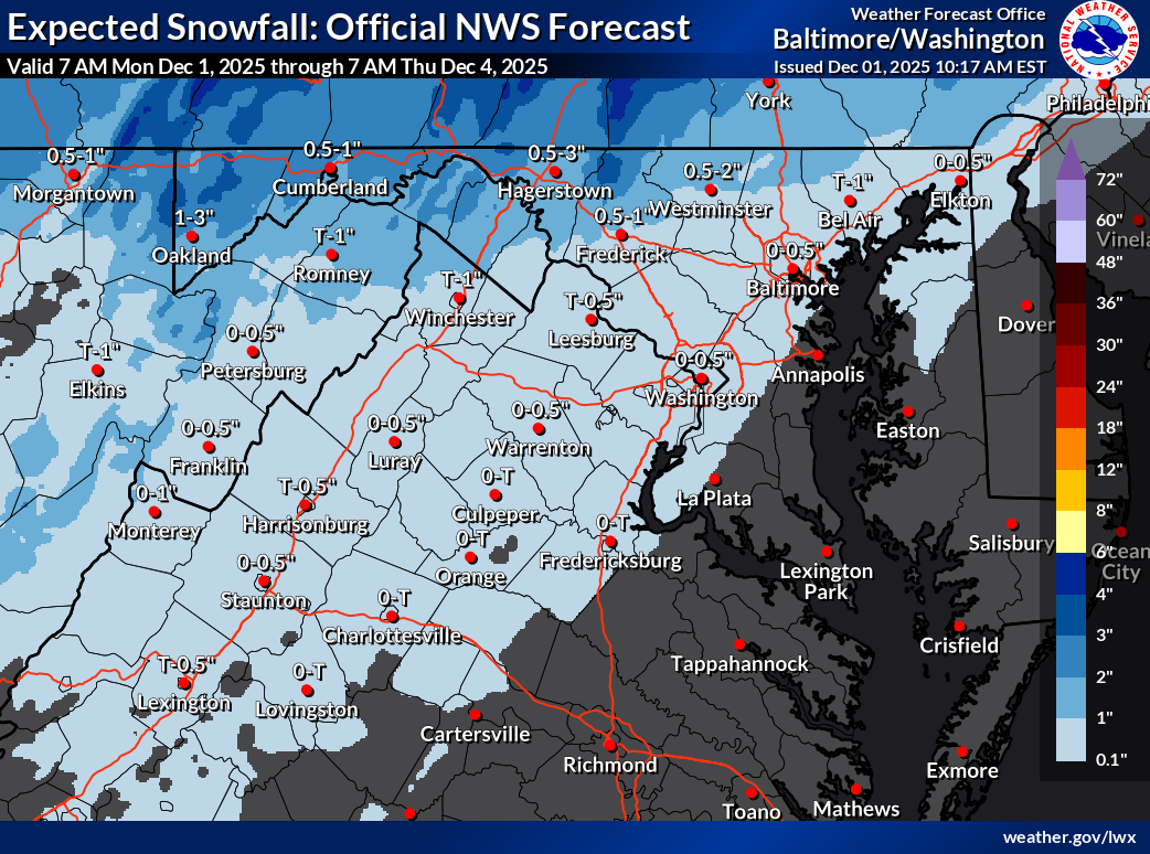
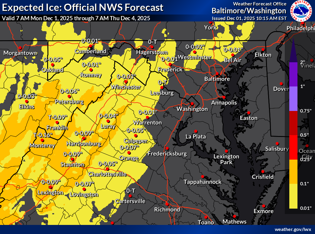
🌧️ Cold Air Gets Pushed Out Tonight – Sleet and Snow Stay Minor

Southerly winds will quickly erode the cold air tonight, cutting down snow chances. A wintry mix will move in overnight into tomorrow morning. With colder temps on elevated surfaces, a light glaze will be possible.

Some sleet and a few snowflakes may mix in, but they won’t amount to much. Slick spots are possible on shaded or elevated surfaces, and a thin glaze could develop on trees.

🌑️ Chilly Tuesday Ahead

Temperatures will likely stay in the mid-30s through the day tomorrow. With lingering warmth from fall, early winter is off to a tricky start.

I will update later on the frozen chances for Friday night.

The forecast:
oday: Hi 41 🌀️ Lo 28 β„οΈπŸŒ§οΈ60% – Mostly sunny, becoming cloudy with sleet possible overnight

Tuesday: Hi 38 β„οΈπŸŒ§οΈ100% Lo 24 πŸŒ™ – Snow, sleet, and freezing rain changing to all rain by late morning, then clearing late

Wednesday: Hi 39 β˜€οΈ Lo 23 πŸŒ™ – Sunny during the day, remaining mostly clear at night

Thursday: Hi 41 β›… Lo 18 πŸŒ™ – Partly sunny during the day and mostly clear overnight

Friday: Hi 32 ❄️ Lo 27 β„οΈπŸŒ§οΈ60% – Mostly cloudy with a chance of afternoon snow, becoming freezing rain overnight

Saturday: Hi 42 β„οΈπŸŒ¦οΈ30% Lo 28 ☁️ – Mostly cloudy with a chance of rain during the day

Sunday: Hi 42 β›… Lo 27 πŸŒ™ – Partly sunny

#loudoun #loudouncountyva #vawx #loudounweather #loudounva #virginiaweather

Please support Tree of Life Ministries, an important organization to me! https://www.tolministries.org


image.png
image.png

image.png

Loudoun County Weather Outlook for Sunday, November 30, 2025

11/30/2025
Wintry week ahead!

🌨️ Wintry Mix This Morning
A mix of sleet, snow, and some rain should wrap up by noon or 1 PM. Temps will rise to around 40Β°F with breezy conditions.

❄️ Snow Monday Night
Snow is expected Monday night into Tuesday morning with 1 to 2 inches possibleβ€”though an inch looks more likely right now.

🌧️ Mixed Bag Tuesday
Tuesday starts cold with another round of snow or rain by afternoon. We could see a return to sleet or snow by evening. Highs stay chilly in the 30s to near 40.

🌬️ Staying Cold Midweek and really cold Friday!
The cold pattern continues through the week with highs generally in the 30s and low 40s. Friday's high will only be around freezing!

⚠️ Watching Friday Night
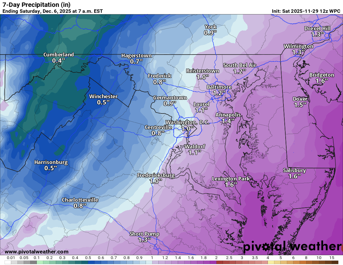
Another round of wintry weather will move in on Friday night. It could start as snow, switch to ice Saturday morning, then transition to plain rain.

πŸ“† Looking Ahead
Next week might trend milder, but confidence is low. More wintry threats could return by mid-month.

The Forecast:
Today: Hi 45 🌧️50% Lo 28 πŸŒ™ – Mostly cloudy with rain and wintry mix tapering by early afternoon, becoming mostly clear overnight

Monday: Hi 42 🌀️ Lo 28 🌧️70% – Mostly sunny early, with snow likely overnight and light accumulation expected

Tuesday: Hi 40 🌧️90% Lo 23 πŸŒ™ – Snow and rain likely in the morning, tapering to light rain, becoming partly cloudy at night

Wednesday: Hi 39 β˜€οΈ Lo 24 πŸŒ™ – Sunny and cold, with a clear, chilly night

Thursday: Hi 44 β›… Lo 18 πŸŒ™ – Partly sunny and seasonable, then cold overnight

Friday: Hi 32 ☁️ Lo 26 ❄️60% – Mostly cloudy and cold with snow likely overnight

Saturday: Hi 39 β„οΈπŸŒ§οΈ40% Lo 27 ☁️ – Mostly cloudy with mixed precipitation transitioning to rain

#loudoun #loudouncountyva #vawx #loudounweather #loudounva #virginiaweather

Please support Tree of Life Ministries, an important organization to me! https://www.tolministries.org


image.png

Loudoun County Weather Outlook for Saturday, November 29, 2025

11/29/2025
❄️ Cold Saturday with a Chance of Flurries
Temps stay chilly today around 40Β°F, but at least the winds have calmed down. A few snow showers could sneak in late tonight with a chance of some flakes or mixed showers into Sunday morning.

🌬️ Wintry Mix Possible Early Tuesday
Sunday stays cold with highs in the low to mid 40s. Monday will be similar, and by late Monday night into early Tuesday, a mix of snow and sleet possible before changing to mostly rain Tuesday afternoon.

πŸ₯Ά Staying Cold All Week
Highs hover near 40 or even upper 30s much of next week. Another system could bring wintry weather by next weekend, so something to watch.

🌨️ More Snow Chances in the Long Range
Several smaller systems may clip the area, and if the cold holds, snow chances are still on the table into mid-December.

The forecast:
Today: Hi 41 β˜€οΈ Lo 30 πŸŒ™ – Sunny with calm winds, becoming cloudy overnight

Sunday: Hi 46 β„οΈπŸŒ¦οΈ40% Lo 28 πŸŒ™ – Chance of snow early transitioning to rain by late morning, then partly cloudy at night

Monday: Hi 41 β˜€οΈ Lo 28 β„οΈπŸŒ§οΈ50% – Mostly sunny during the day, with a chance of snow mixing with rain overnight

Tuesday: Hi 38 β„οΈπŸŒ§οΈ80% Lo 26 πŸŒ§οΈβ„οΈ30% – Rain and snow during the day, becoming all rain by afternoon, with a chance of mixed precipitation in the evening

Wednesday: Hi 41 β˜€οΈ Lo 25 πŸŒ™ – Sunny and cold

Thursday: Hi 42 β›… Lo 22 πŸŒ™ – Partly sunny and chilly

Friday: Hi 37 ☁️ Lo 23 ❄️ – Mostly cloudy with a chance of snow overnight
#loudoun #loudouncountyva #vawx #loudounweather #loudounva #virginiaweather

Please support Tree of Life Ministries, an important organization to me! https://www.tolministries.org

Facebook: https://facebook.com/loudounwx
Twitter: https://twitter.com/loudounwx
Instagram: https://www.instagram.com/loudounweather/
On the Web @ https://loudounweather.com
TikTok: https://www.tiktok.com/@loudounweather

image.png

Loudoun County Weather Outlook for Friday, November 28, 2025

11/28/2025
❄️ Cold and Windy Black Friday
Bundle up if you're heading out for post-Thanksgiving shopping. Highs stay in the upper 30s with gusty winds making it feel even colder. Tonight drops into the low to mid-20sβ€”make sure hoses and spigots are winterized.

🌬️ Cold Saturday, Light Snow Possible Late
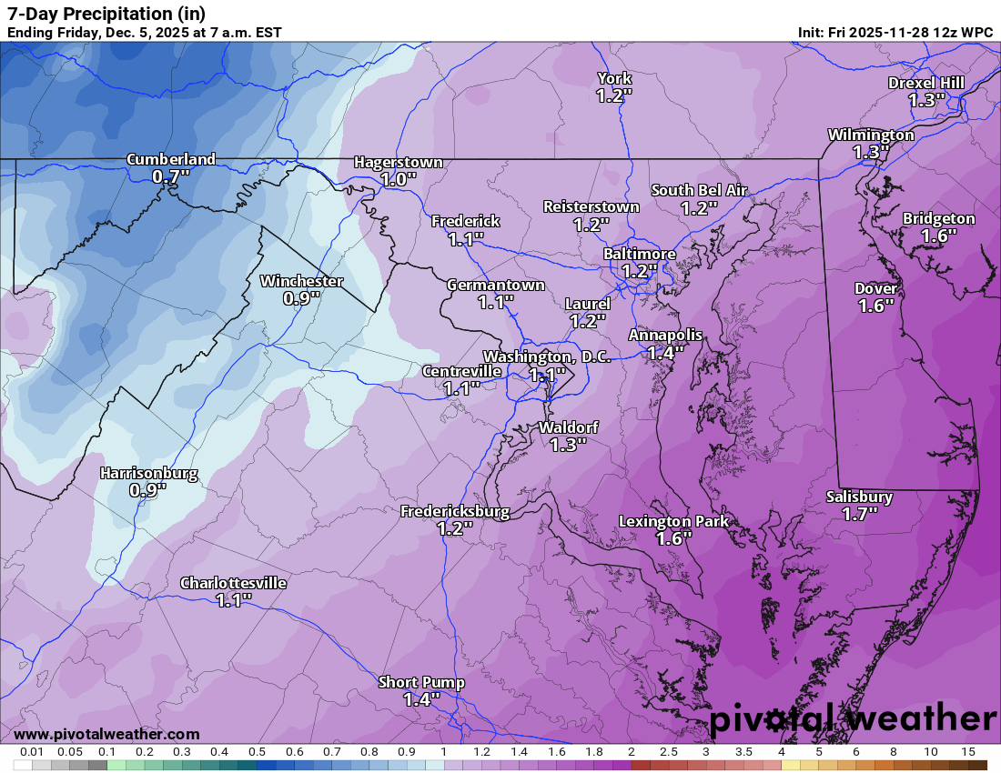
Saturday stays chilly with highs near 40, but winds ease through the day. Late Saturday night into early Sunday could bring a bit of light snow before changing to rain.

🌧️ Chilly Start to the Week
Monday looks cold with highs in the low to mid-40s. Another chance for light snow Monday night mixing with rain by Tuesday morning. It doesn’t look like a big deal, just some cold rain.

🌾 Drought Continues
We’re still in a severe drought, so any moisture helps. The cold pattern looks to hold through next week

The forecast:
Today: Hi 39 🌞 Lo 24 πŸŒ™ – Scattered morning flurries, becoming sunny and breezy

Saturday: Hi 41 β˜€οΈ Lo 28 ❄️30% – Sunny during the day, turning mostly cloudy overnight with a chance of snow late

Sunday: Hi 44 β„οΈπŸŒ§οΈ60% Lo 28 ☁️ – Rain and snow likely in the morning, changing to rain; mostly cloudy overnight

Monday: Hi 40 🌞 Lo 27 ❄️30% – Mostly sunny during the day, chance of snow late at night

Tuesday: Hi 37 β„οΈπŸŒ§οΈ50% Lo 25 🌧️30% – Chance of rain and snow and sleet switching to cold rain

Wednesday: Hi 40 🌞 Lo 23 πŸŒ™ – Mostly sunny and cold, clear and chilly overnight

Thursday: Hi 43 β›… Lo 25 πŸŒ™ – Partly sunny and cold

#loudoun #loudouncountyva #vawx #loudounweather #loudounva #virginiaweather

Please support Tree of Life Ministries, an important organization to me! https://www.tolministries.org

image.png