Local weather. A little perspective.Loudoun County, VirginiaOfficial NWS alerts ↗
Loudoun County, Virginia

Author: admin

Loudoun County Weather Outlook for Monday, February 10, 2025

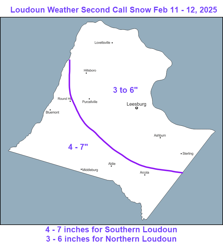
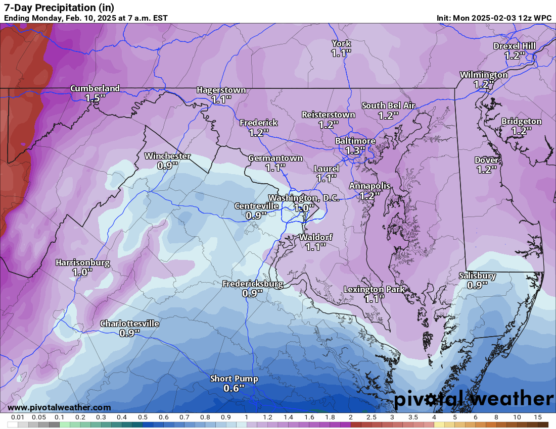
2/10/2025 – UPDATES ON SNOW! Snow should start tomorrow between 11am and 2pm. The snow will not be super heavy but will accumulate. The temps will be at or just below freezing, so it will be easy for salt and the plowers to handle. Snow will get heavier tomorrow night. By the time it wraps up on Wednesday we could see 3 to 6 inches, with southern areas seeing 4 – 7 inches.

Mixed precipitation will be coming back on Wednesday evening and should turn over to rain, but we will need to watch for some icing and the trees may be heavy with the rain and snow combined.

I go over the models in my video on YouTube – if interested – https://lowx.us – nothing fancy about it at all! 🙂

More mixed precipitation looks possible this weekend, but mainly rain from what I can see.

Attached are my thoughts on the amounts.

The forecast:
Today: Hi 42 🌤️ Lo 27 ☁️ – Mostly sunny with light northwest winds, becoming mostly cloudy overnight

Tuesday: Hi 33 ❄️90% Lo 30 ❄️100% – Snow developing in the afternoon with 1 to 2 inches possible, continuing overnight with 2 to 4 more inches

Wednesday: Hi 35 ❄️🌧️100% Lo 33 🌧️100% – Snow mixed with freezing rain in the morning, then changing to rain in the afternoon and continuing overnight

Thursday: Hi 46 ⛅ Lo 25 🌙 – Partly sunny and partly cloudy overnight

Friday: Hi 36 🌤️ Lo 25 ☁️ – Mostly sunny with increasing clouds overnight

Saturday: Hi 41 ❄️🌧️70% Lo 36 🌧️90% – Rain and snow likely during the day, turning to rain overnight

Sunday: Hi 46 ❄️🌧️70% – Rain and snow likely

#loudoun #loudouncountyva #vawx #loudounweather #loudounva #virginiaweather

Please support Tree of Life Ministries, an important organization to me! https://www.tolministries.org

Loudoun County Weather Outlook for Thursday, February 6, 2025

2/6/2025 – Three things to cover! We will have a nice day tomorrow.

We will have a chance of some more mixed precipitation on Saturday. May have a little snow and sleet and then some freezing rain. We will have to see how this pans out because it is close to being a bit more of a challenge.

We get a break on Sunday!

Monday – late in the day and overnight, we should see some snow and then snow overnight. On Tuesday, we could see snow transition to sleet and freezing rain. How long things stay snow will be something to watch.

There is a chance more mixed precipitation could come on Wednesday and Thursday, but I believe it will be too warm. We will have to wait and see.

The long-range pattern does look like it will turn colder, and we could have better chances of true snow systems.

So, ya, it will probably be a bit of a wintry week, but how much snow/ice/rain we get is going to be hard to pin down.

This is the NWS Forecast – I think you should have it as low confidence for next week!

Tonight: Lo 36 ☁️ – Mostly cloudy with southwest winds shifting to northwest after midnight

Friday: Hi 45 🌤️ Lo 28 ☁️ – Mostly sunny and breezy with gusts up to 23 mph, becoming mostly cloudy at night

Saturday: Hi 33 🌨️70% Lo 31 🌧️90% – Snow and sleet changing to rain or freezing rain, then all rain overnight

Sunday: Hi 45 🌤️ Lo 28 ☁️ – Mostly sunny during the day, becoming mostly cloudy at night

Monday: Hi 38 🌨️30% Lo 29 🌨️60% – A chance of snow during the day, with snow likely overnight

Tuesday: Hi 35 ❄️80% Lo 29 ❄️60% – Snow expected throughout the day and into the night

Wednesday: Hi 36 ❄️40% Lo 29 🌧️❄️70% – A chance of snow during the day, with a mix of rain, snow, and freezing rain likely overnight

Thursday: Hi 39 🌧️❄️60% – Rain and snow likely with mostly cloudy skies

#loudoun #loudouncountyva #vawx #loudounweather #loudounva #virginiaweather

Please support Tree of Life Ministries, an important organization to me! https://www.tolministries.org


image.png

Loudoun County Weather Outlook for Wednesday, February 5, 2025

2/5/2025 – What a date for a Weather Snow Lover! 15 years ago, I was forecasting the chance of 30+ inches of snow on Snowmageddon! I was shocked it came true! Anyway, we will just have some mixed precip tonight with the chance of some glazing on trees and shaded areas… but most roads should be fine. Sidewalks could become icy.

We may have some mixing Friday night into Saturday, but that is less impressive.
All Winter Weather Lovers eyes are on Monday and Tuesday next week when we have the chance for some significant snow and ice. How much of each is still too difficult to know. I think we will have to get a bit closer and understand what happens Monday to see if it can set up some colder air for Tuesday's big system.

The forecast:
Today: Hi 35 ☁️20% Lo 30 🌧️100% – Cloudy with a slight chance of snow and sleet in the afternoon, becoming freezing rain and sleet at night with ice accumulation possible

Thursday: Hi 49 🌧️90% Lo 37 ☁️20% – Rain and freezing rain in the morning, ending as rain before becoming mostly cloudy at night with a slight chance of showers

Friday: Hi 49 ☀️ Lo 27 ☁️❄️20% – Sunny and breezy, becoming mostly cloudy at night with a slight chance of snow

Saturday: Hi 38 ❄️🌧️70% Lo 34 🌧️80% – A chance of snow in the morning, then rain likely through the day and night

Sunday: Hi 48 ☀️ Lo 28 🌙 – Mostly sunny and partly cloudy at night

Monday: Hi 37 ❄️30% Lo 28 ❄️40% – A chance of snow during the day and night under partly to mostly cloudy skies

Tuesday: Hi 35 ❄️80% Lo 27 ❄️🌧️ – Snow likely throughout the day possibly mixing with sleet and freezing rain.

#loudoun #loudouncountyva #vawx #loudounweather #loudounva #virginiaweather

Please support Tree of Life Ministries, an important organization to me! https://www.tolministries.org

Loudoun County Weather Outlook for Tuesday, February 4, 2025

2/4/2025—Here's a quick update: First, we will get some mixing stuff tomorrow night into Thursday. Then, more snow and mix could fall Friday night into Saturday.

SPECULATION – We may line up for a significant snowstorm next week! This could hit Tuesday! This is slowly becoming more possible based on models! We will see!

The forecast:
Today: Hi 57 🌤️ Lo 29 🌙 – Partly sunny, becoming clear in the afternoon, with increasing clouds at night.

Wednesday: Hi 36 🌨️30% Lo 31 🌨️100% – Cloudy with a 30% chance of snow and sleet in the afternoon; Expect freezing rain and sleet overnight

Thursday: Hi 49 🌧️90% Lo 38 🌧️30% – Rain and maybe some freezing rain early.

Friday: Hi 49 ☀️ Lo 28 🌙 – Sunny during the day, with mostly clear skies at night.

Saturday: Hi 38 🌨️80% Lo 34 🌧️70% – Rain and snow likely becoming all rain late

Sunday: Hi 50 🌤️ Lo 27 🌙 – Partly sunny during the day, with partly cloudy skies at night.

Monday: Hi 41 🌤️ Lo 25 🌙 – Mostly sunny during the day, becoming mostly cloudy at night.

Tuesday: Hi 37 🌨️50% Lo 26 🌨️ – Snow possible! (may be significant)

#loudoun #loudouncountyva #vawx #loudounweather #loudounva #virginiaweather

Please support Tree of Life Ministries, an important organization to me! https://www.tolministries.org

Loudoun County Weather Outlook for Monday, February 3, 2025

2/3/2025 – It is going to be a very Mild/Warm day with a high near 60! It'll still be mild and breezy tomorrow. We may see some snow/rain/sleet mix Wednesday into Wednesday night. Things will clear up early Thursday, and temps could rocket into the 60s! The weekend looks unsettled and may include some rain/snow/sleet mix and just some plain rain.
The following week looks to return to a bit colder and there are some wintry weather threats, but this is so far off that there may be nothing or rain. The very long range does look like it will try and turn cold for the second half of the month, but that is too far off to be trusted.

The forecast:
Today: Hi 56°F 🌥️ Lo 44°F ☁️ – Mostly cloudy with calm winds becoming south 5 to 9 mph in the afternoon

Tuesday: Hi 55°F 🌤️ Lo 32°F ☁️ – Mostly sunny with northwest wind 8 to 14 mph, gusts up to 23 mph; becoming mostly cloudy at night.

Wednesday: Hi 40°F 🌨️50% Lo 34°F 🌧️80% – Cloudy with a 50% chance of sleet before 1pm, then a chance of rain and sleet; rain at night with an 80% chance of precipitation.

Thursday: Hi 56°F 🌧️70% Lo 36°F ☁️ – Very Mild with rain likely, mainly before 1pm; mostly cloudy at night.

Friday: Hi 48°F 🌤️ Lo 30°F ☁️ – Mostly sunny; mostly cloudy at night.

Saturday: Hi 45°F 🌧️50% Lo 33°F ☁️ – Mostly cloudy with a 50% chance of rain (possibly mixed with sleet/snow at onset)

Sunday: Hi 48°F 🌧️50% Lo 30°F ☁️ – Cloudy with a 50% chance of rain

#loudoun #loudouncountyva #vawx #loudounweather #loudounva #virginiaweather

Please support Tree of Life Ministries, an important organization to me! https://www.tolministries.org