Local weather. A little perspective.Loudoun County, VirginiaOfficial NWS alerts ↗
Loudoun County, Virginia

Author: admin

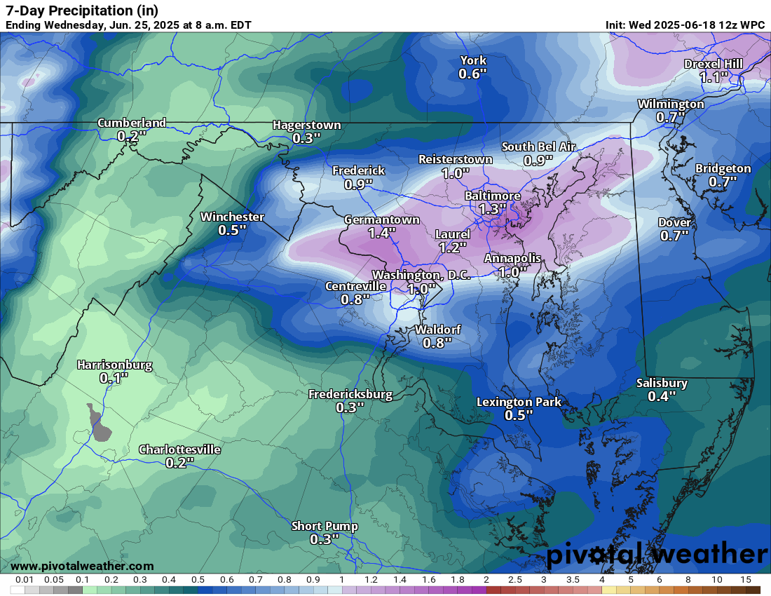
Loudoun County Weather Outlook for Wednesday, June 18, 2025

6/18/2025
⛈️ Stormy and Humid Today
After a foggy start, things are warming up fast! Expect a warm and humid day with highs climbing into the mid to upper 80s. Scattered showers and thunderstorms are likely, especially through the middle part of the day. A few storms could be strong, but they’ll be more isolated.

🌩️ HOT with Strong Storms Possible Thursday
Thursday brings another round of showers and thunderstorms with a higher chance for strong to severe storms.

🌤️ Brief Break Friday
We catch a break on Friday with mostly sunny skies and highs in the low to mid 80s. A beautiful day before the heat cranks up again!

🔥 Turning Up the Heat This Weekend
Saturday starts the sizzle with highs in the low 90s and increasing humidity. By Sunday, we’re into the low to mid 90s, and the heat intensifies even further into next week.

🥵 Dangerous Heat Next Week
Monday through Wednesday look brutally hot with highs in the mid to upper 90s. With high humidity, it will feel downright oppressive. Be sure to stay cool and hydrated! The hot temperatures will continue through the week

The forecast:
Today: Hi 86 ⛈️70% Lo 71 🌙 – Afternoon thunderstorms

Juneteenth: Hi 91 ⛈️80% Lo 64 🌧️80% – Showers and storms in the afternoon. Some could be severe, with heavy rain.

Friday: Hi 84 ☀️ Lo 64 ☁️ – Sunny

Saturday: Hi 89 ☀️ Lo 69 🌙 – Sunny and hot

Sunday: Hi 93 🌤️ Lo 73 🌙 -🥵 Mostly sunny and hot

Monday: Hi 96 ☀️ Lo 75 🌙 – 🥵 Sunny and very hot

Tuesday: Hi 97 ☀️ Lo 75 🌙 – 🌡️🥵 Sunny and extremely hot

#loudoun #loudouncountyva #vawx #loudounweather #loudounva #virginiaweather

Please support Tree of Life Ministries, an important organization to me! https://www.tolministries.org


Please support Tree of Life Ministries, an important organization to me! https://www.tolministries.org

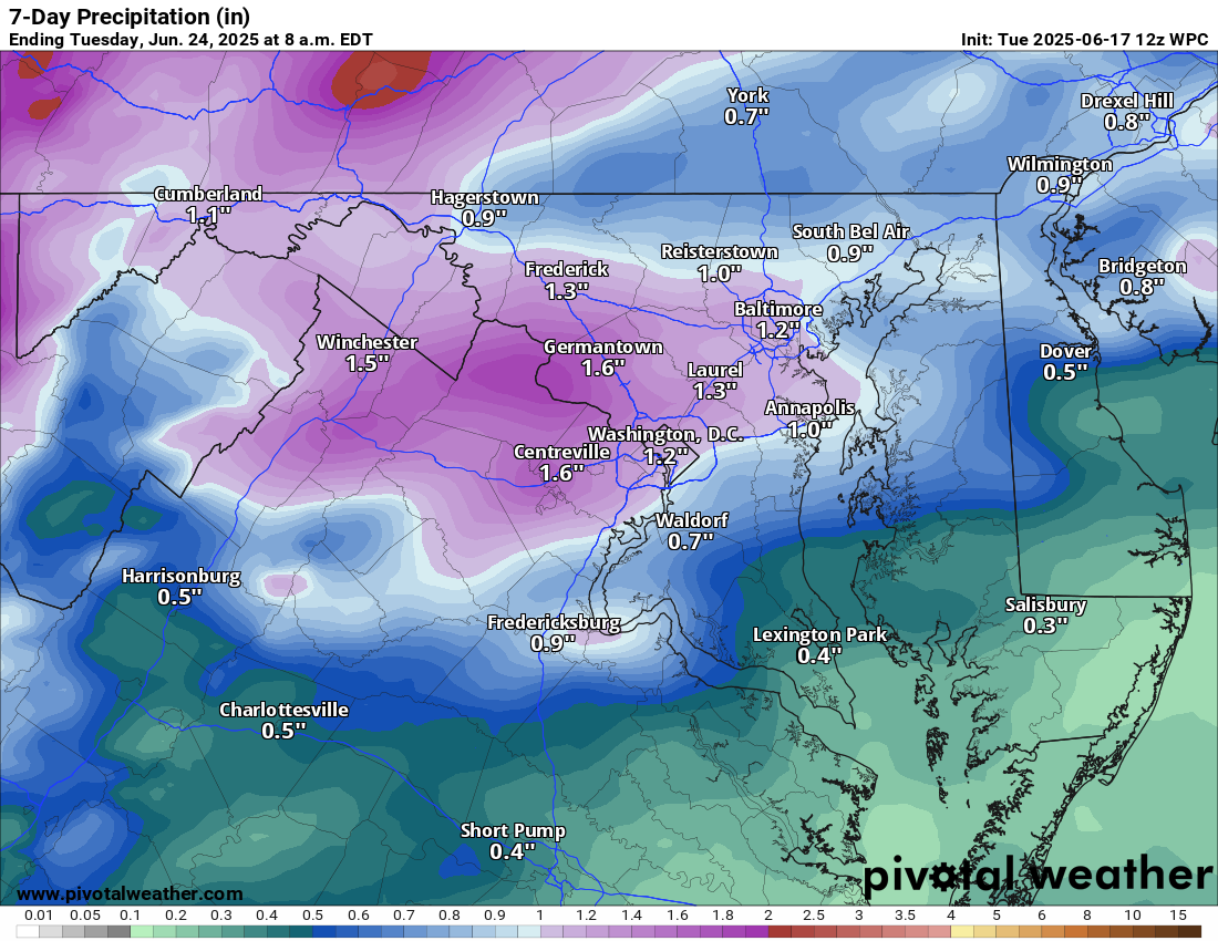
Loudoun County Weather Outlook for Tuesday, June 17, 2025

6/17/2025
🌥️ Mostly Cloudy with a Humid Feel Today
Expect mostly cloudy skies, but becoming sunny. It will feel more humid, and there’s a chance of scattered showers and storms. We're under a marginal risk for severe weather, mainly for gusty winds.

🌡️ Turning Hot and Stormy Wednesday
Temps jump to around 90°F with humidity. Look for afternoon and evening storms, some of which may be strong to severe. Another marginal risk is in place.

🔥 Hot Thursday
Cooler and a touch less humid with highs in the mid-80s. Heat index will push 100°F! We are under a slight risk (15%) for severe storms.

🌤️ Brief Break Friday
A bit cooler and slightly less humid, with highs in the mid-80s.

🌡️ Heat Builds Through the Weekend
Back to 90°F Saturday, then surging to the mid-90s Sunday

🥵 Extreme Heat Next Week
Monday's highs will be in the mid to upper 90s, with heat indices nearing 105°F. This dangerous heat looks to linger through much of next week.

The forecast:
Wednesday: Hi 89 ⛈️80% Lo 70 🌧️80% – Showers and thunderstorms with isolated severe storms possible

Wednesday: Hi 89 ⛈️80% Lo 70 🌧️80% – Showers and thunderstorms with isolated severe storms possible.

Thursday (Juneteenth): Hi 91 🌧️60% Lo 65 🌧️60% – Mostly sunny morning, then showers and thunderstorms likely developing in the afternoon and early evening. There could be strong to severe storms.

Friday: Hi 86 ☀️ Lo 66 🌙 – Sunny

Saturday: Hi 91 🌤️ Lo 71 🌙 – Hot and sunny.

Sunday: Hi 95 🥵☀️ Lo 74 🌙 – Hot and sunny

Monday: Hi 97 🌡️☀️ Lo 75 🌙 – Very hot

#loudoun #loudouncountyva #vawx #loudounweather #loudounva #virginiaweather

Please support Tree of Life Ministries, an important organization to me! https://www.tolministries.org


Please support Tree of Life Ministries, an important organization to me! https://www.tolministries.org

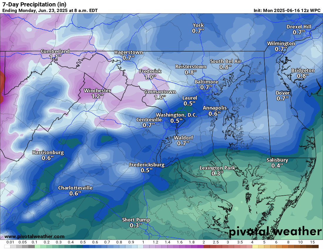
Loudoun County Weather Outlook for Monday, June 16, 2025

6/16/2025
Cooler than normal start to the Week
Today will feel more like early spring than mid-June, with a noticeable chill in the air and below-average temperatures.

🔥 Warm-Up Begins Tuesday
Tomorrow brings a sharp turnaround as highs into the low 80s, with much hotter temps on the way.

🥵 Heat Peaks Midweek
Wednesday and Thursday crank things up into the 90s. Thursday afternoon and evening could feature strong showers and storms—some potentially severe—that will cool us off briefly.

⛈️ Storms Thursday ➡️ Cooler Friday
Expect a dip into the mid-80s on Friday following Thursday's storms, offering a short-lived break from the heat.

🌡️ Heating Back Up This Weekend
Upper 80s on Saturday, then surging into the 90s again Sunday. Low to mid 90s expected, with next week looking very hot and summery!

The forecast:
Today: Hi 68 ⛈️50% Lo 65 🌧️50% – Scattered showers with thunderstorms possible after 3 pm, continuing overnight.

Tuesday: Hi 81 ⛈️80% Lo 69 🌧️80% – A chance of showers early, then showers and thunderstorms likely after 2 pm into early Tuesday morning.

Wednesday: Hi 89 🌦️40% Lo 71 🌧️30% – Mostly sunny with a chance of afternoon thunderstorms; clearing to mostly clear overnight.

Thursday (Juneteenth): 🥵 Hi 91 ⛈️60% Lo 65 🌧️60% – Mostly sunny with showers and thunderstorms likely after 2 pm and again before 8 pm.

Friday: Hi 85 🌞 Lo 62 🌙 – Sunny and dry throughout the day and night.

Saturday: Hi 88 🌤️ Lo 68 🌙 – Mostly sunny with mild evening skies.

Sunday: 🥵🌡️ Hi 94 🌞 Lo 72 🌙 – Hot and sunny

#loudoun #loudouncountyva #vawx #loudounweather #loudounva #virginiaweather

Please support Tree of Life Ministries, an important organization to me! https://www.tolministries.org


Please support Tree of Life Ministries, an important organization to me! https://www.tolministries.org

image.png

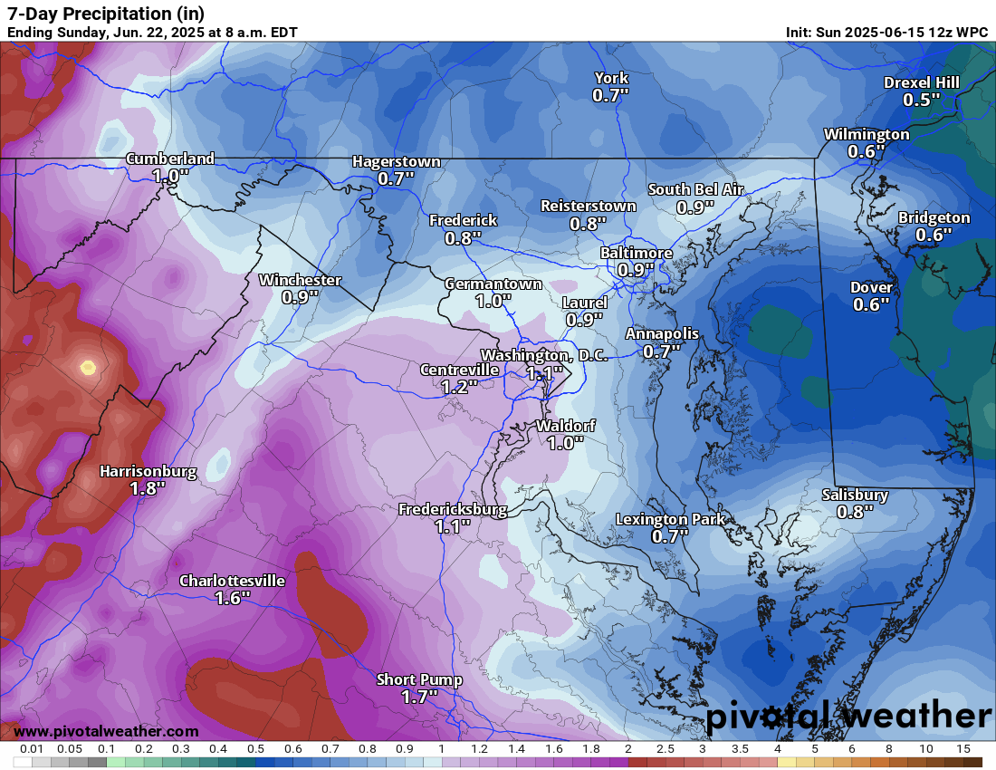
Loudoun County Weather Outlook for Sunday, June 15, 2025

6/15/2025
🔥 Eyeing 100° Later This Month?
Thanks for tuning in! Here's a quick look ahead:

🌧️ Wet Weekend Continues
Scattered showers and storms linger through Sunday with temps holding near 70°F. Expect damp and dreary conditions to stick around a bit longer.

🌦️ Storm Chances Into the Week
Rain chances continue Monday and Tuesday, with highs in the 70s Monday and warming into the 80s Tuesday.

🌡️ Summer Heat Midweek
By Wednesday and Thursday, we’re flirting with upper 80s to near 90°F—classic summer heat with afternoon storm chances.

⛈️Watching for Severe weather Thursday
We have a chance for some severe storms Thursday

🥵 Looking Ahead…
Our first shot at 100°F could arrive late in the month. Stay tuned as we track that heat potential!

The forecast:
Today: Hi 69 🌧️60% Lo 61 🌧️80% – Mostly cloudy with a chance of showers and thunderstorms

Monday: Hi 69 🌧️60% Lo 64 🌧️40% – Cloudy with showers likely and thunderstorms possible after 2 pm

Tuesday: Hi 77 🌧️70% Lo 68 🌧️60% – Cloudy with showers likely and thunderstorms possible late afternoon

Wednesday: Hi 89 🌦️40% Lo 71 🌧️30% – Mostly sunny with a chance of late‑day showers and storms; partly cloudy overnight with slight shower potential.

Thursday (Juneteenth): Hi 90 ⛈️50% Lo 66 🌧️️30% – Mostly sunny with a chance of afternoon showers and storms; partly cloudy overnight with slight shower potential.

Friday: Hi 85 ☀️ Lo 64 🌙 – Sunny Friday, becoming mostly clear overnight.

Saturday: Hi 88 ☀️ Lo 69 🌙 – Sunny throughout the day and clear at night.
#loudoun #loudouncountyva #vawx #loudounweather #loudounva #virginiaweather

Please support Tree of Life Ministries, an important organization to me! https://www.tolministries.org


Please support Tree of Life Ministries, an important organization to me! https://www.tolministries.org


image.png

Loudoun County Weather Outlook for Saturday, June 14, 2025

6/14/2025
🌧️ Damp with Flood Concerns
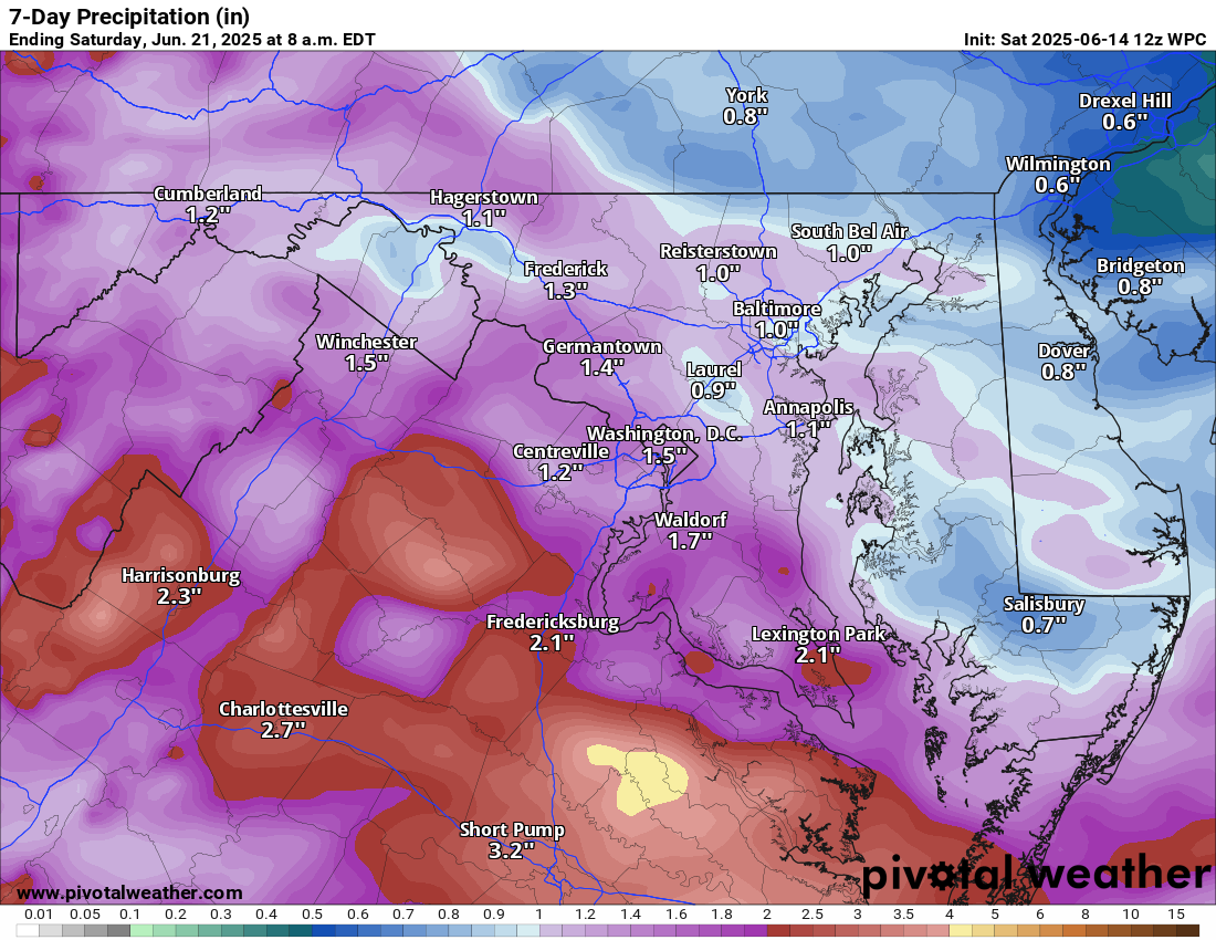
Rain showers and scattered thunderstorms are expected today, with the heaviest rain likely after 5 PM. A Flood Watch is in effect from 2 PM into this evening—some storms could drop heavy rainfall. Highs will be near 80°F.

🌦️ More Showers Sunday
Tomorrow will stay damp with scattered showers and a cooler feel. Highs will be closer to 70°F, with an easterly flow keeping things more misty than stormy.

🌧️ More Rain Early Week
Showers and storms return Monday and Tuesday, with highs in the 70s Monday and warming into the 80s by Tuesday.

⛈️ Stormy and Hot Midweek
Wednesday and Thursday bring summer heat—highs pushing upper 80s to the low 90s°F—and the potential for afternoon thunderstorms both days.

🌤️ A Break by Friday?
A brief cool down may arrive Friday before temps rise again heading into next weekend.

The forecast:

Today: Hi 80 🌧️80% Lo 64 🌧️80% – Showers and possibly a thunderstorm this afternoon, continuing into the night with scattered storms.

Sunday: Hi 69 🌧️80% Lo 62 🌧️80% – Showers likely, with thunderstorms possible both day and night.

Monday: Hi 69 🌧️50% Lo 64 ☁️40% – Cloudy with a chance of showers and thunderstorms

Tuesday: Hi 80 🌦️60% Lo 68 🌧️60% – Mostly cloudy with showers and storms likely, especially after 2 pm.

Wednesday: 🥵 Hi 89 🌦️40% Lo 71 🌧️30% – Partly sunny with a chance of storms late afternoon

Juneteenth (Thursday): 🥵 Hi 91 🌧️60% Lo 67 🌧️60% – Mostly sunny with showers and thunderstorms likely

Friday: Hi 85 ☀️ Lo 63 🌙 – Sunny and a bit less hot!

#loudoun #loudouncountyva #vawx #loudounweather #loudounva #virginiaweather

Please support Tree of Life Ministries, an important organization to me! https://www.tolministries.org


Please support Tree of Life Ministries, an important organization to me! https://www.tolministries.org