Local weather. A little perspective.Loudoun County, VirginiaOfficial NWS alerts ↗
Loudoun County, Virginia

Author: admin

Loudoun County Weather Outlook for Sunday, February 12, 2023

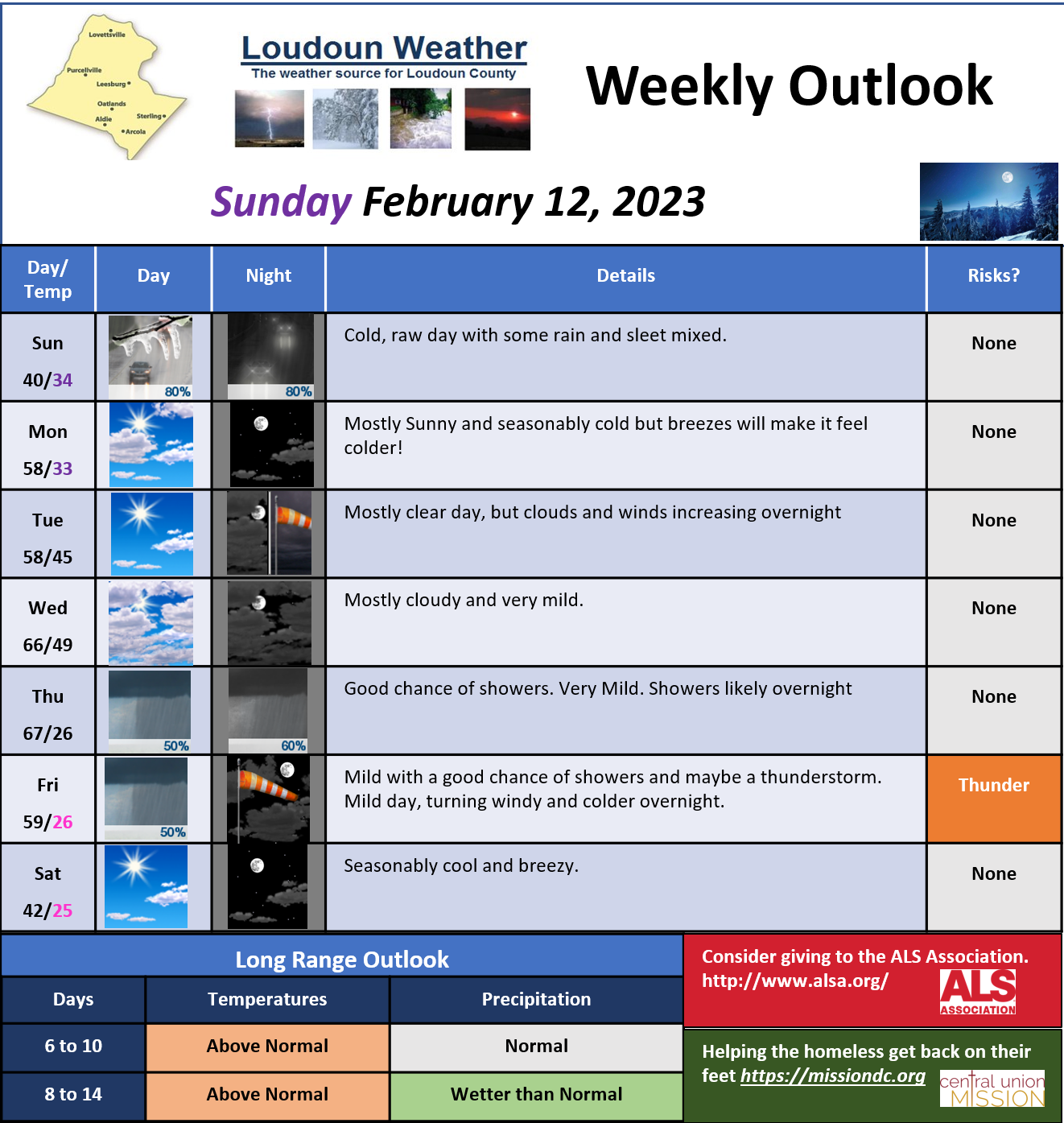
2/12/2023 – A raw day with sleet and rain becoming mainly rain. The rain will not be that heavy. If you travel towards the SW part of Virginia or over the Blue Ridge, you may experience a mixed bag, so travel safely.

The week will turn mild and then almost warm by Thursday. Rain showers Thursday and Friday. As the front pushes through Friday, some thunderstorms may be possible! Then we turn seasonable next weekend.


The super long-range is not looking too wintry, but the colder air next weekend may give minimal opportunity for something to happen. It is very unlikely at this point.


I don’t like the way the upper-level weather patterns look for snow chances as we close out winter. (You would like them if you do not like snow!) Soon it will be March, which is the start of Meteorological Spring!

I will keep watch!
Loudoun County Weather Outlook for Tuesday, January 17, 2023

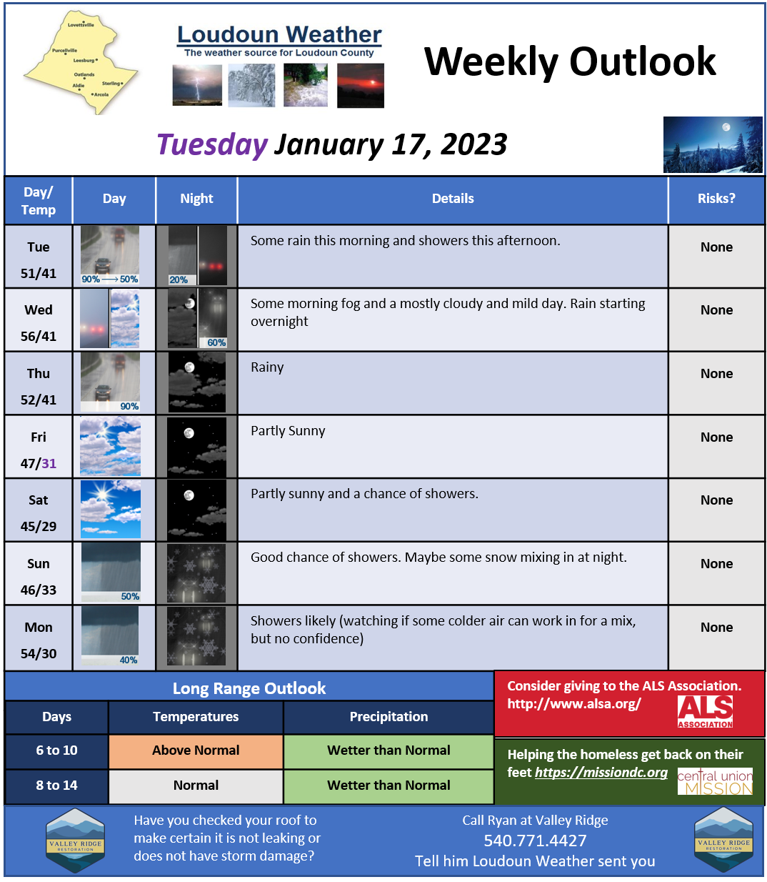
Bit wet today but still mild. Mild tomorrow and then wet Thursday.

This weekend looks like it will have very seasonal temperatures. There is a chance of some showers Sunday and Monday. I am watching to see if any cold air works in to cause some snow, but I have no confidence.

Next Week into the next week we should watch as a window for possible snow. Honestly, if we do not get snow in this window, I am really questioning how much we will get this season. It is not promising for Snow lovers.

Longer range shows the temps moving towards normal, which, this time of year, can mean snow. We will see!

image.png

1/12/2023 Weather Outlook

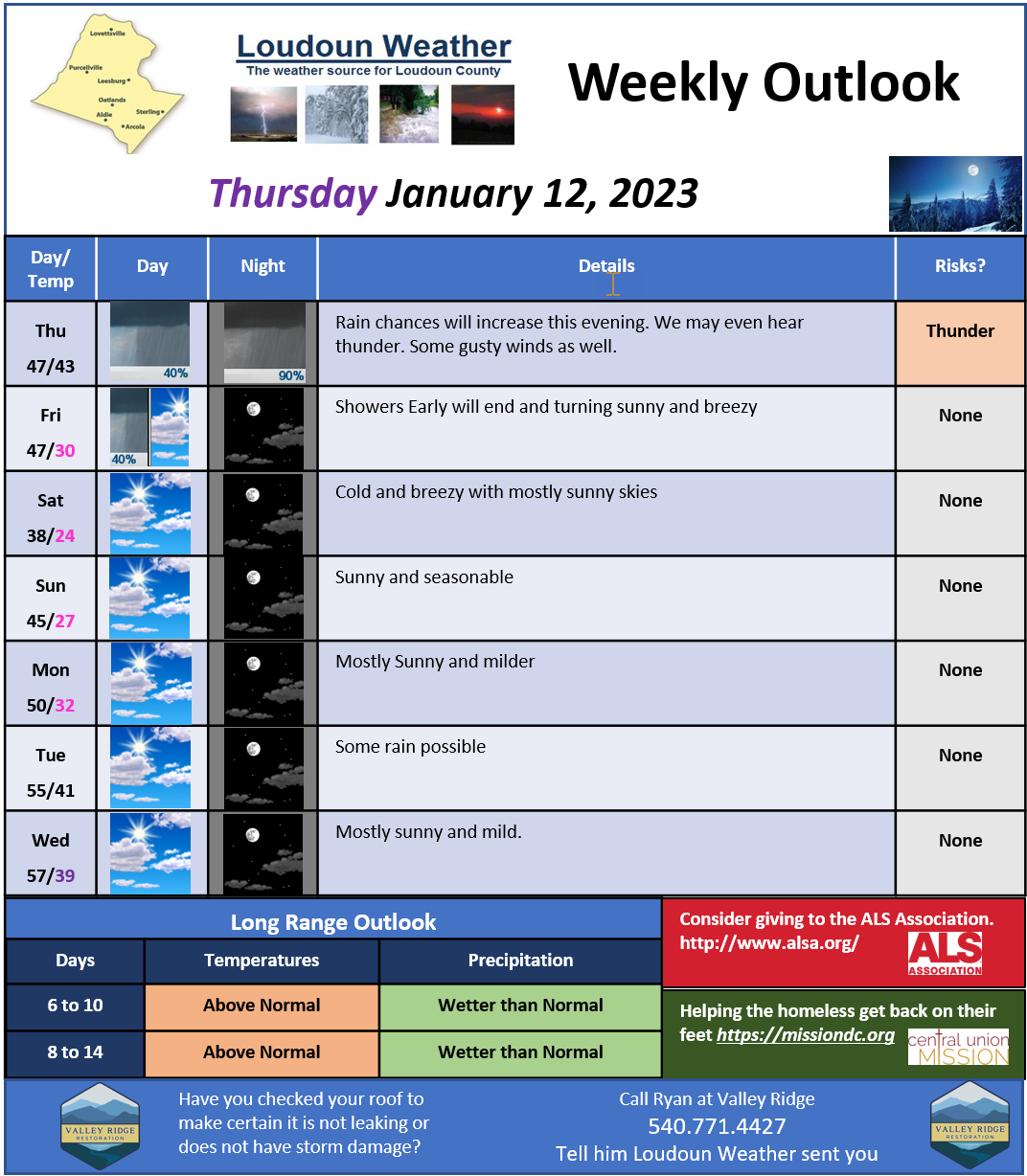
FINALLY a weekly outlook! I have had a bizarre start to 2023 and continue now to fight some potential bug causing me to be dizzy, but I am feeling better!
We will get some gusty rain showers this evening, and this will bring a cold shot. This was originally looking like it may help spawn a storm with snow for us, but that storm will form off the coast. Some snow showers MAY come through tomorrow night, but I am not holding my breath. Very cold Saturday with highs only in the mid to upper 30s. That will be brief as we turn warmer again towards mid-week.
As of now, milder weather will stick around for a bit and wetter conditions. It looks like we could turn colder by the last week of January but there are some conflicting model concerns if you want colder weather. I am thinking we will turn colder for at least a few weeks, but that is pure speculation. We will end up with much below normal snowfall this year if we do not capitalize on that colder weather during that period.
More consistent posts coming! Also, I will be getting more frequent on Twitter.
image.png

Loudoun County Weather Outlook for Friday, December 9, 2022

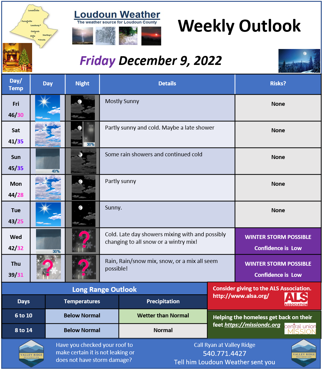
YES, there does appear to be a winter weather event possible late next week!
 
We have definitely turned to a colder airmass and that looks to stay. Real cold may take a bit longer, but by the end of the year, it could get super cold for a period. 
We ended up being sunny today when the system that was looking to do something literally was eaten alive by the block in place that is filtering in the colder air. We will be only in the 40s for the foreseeable future and nighttime lows are trending colder! 
Next Thursday shows as a huge question mark as there does appear to be at least the threat of wintry weather, but will it transform into a bigger winter storm?? Way too early to get too excited about it! I will do daily updates on that risk. 
The longer-range looks colder than normal and it could trend super cold by the end of the year. 
So, with potential snow and at least colder weather, I am certain you need to think about what to do with animals, snow blowers, etc.! I will start saying that more if we get some more confidence next week! 
All for now! I will do a quick check in after noon model runs!
image.png

Loudoun County Weather Update for Sunday, December 4, 2022

12/4/2022 – IS THERE HOPE FOR SNOW?
YES – but it may take longer to be realized!

I know I have been a bit down on the pattern, but it looks like things may have been delayed and not denied! The long-range still holds potential for a wintrier pattern. The first piece in the puzzle DOES come into play this week is the Negative NAO. That may be a bit technical, but it sets up a block for storms moving along in the jet stream, which could help form bigger storms, AND keep colder air from retreating so that *COULD* mean some snow or frozen precipitation!

The pattern will be strange this week, and we have a front nearby with several waves of energy. That means that starting Tuesday through Friday, we could see daily showers. Tuesday looks the wettest, whereas the rest of the week looks like showers, although Thursday may turn wetter overnight.

The following week, things *COULD* become better oriented as better cold air and blocking continue, and we get some other energy coming close by! I need to temper any excitement and remember that the models struggle when patterns change. The biggest part of the miss for this week was trapping the cold air on the right side of the block so it would be in our “backyards” for any storms. That was missed big time by models, and they forecasted it would be here! It was not!

This week will be seasonably mild and above normal Thursday before the cooler next weekend.

A more detailed forecast will be posted tomorrow!

All for now