🌧️ Rainy Start to the Week
Cloudy skies and showers are expected today with highs near 70°F. Rain becomes more widespread tonight and continues into Tuesday.
🌬️ Breezy and Wet Tuesday
A low pressure system off the East Coast will keep us cloudy, cool, and breezy Tuesday with highs in the low 60s and additional showers.
🌦️ Showers Linger
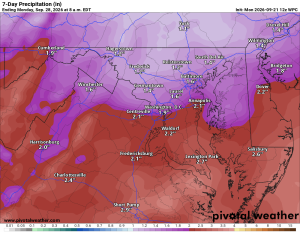
Showers remain possible into Wednesday. Rainfall totals this week should generally reach 1 to 2 inches, with locally higher amounts possible.
🍂 Beautiful Fall Weekend Ahead
Clouds finally begin breaking Friday, setting us up for a great fall weekend. Saturday and Sunday look mostly dry with plenty of sunshine and highs in the mid to upper 60s.
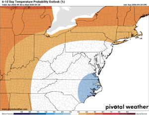
Longer range temperatures look to rebound slightly above normal, with precipitation near to slightly above normal.
The Forecast:
Monday: Hi 70 🌧️50% Lo 57 🌧️90% Chance of showers mainly after 1pm, then showers likely with a possible thunderstorm overnight
Tuesday: Hi 63 🌧️90% Lo 52 🌧️80% Showers throughout the day and into the night, with gusts up to 23 mph during the day and 20 mph overnight
Wednesday: Hi 61 🌧️40% Lo 51 🌧️40% Chance of showers, mostly cloudy with gusty winds up to 22 mph
Thursday: Hi 62 ☁️ Lo 48 ☁️ Mostly cloudy throughout
Friday: Hi 65 🌦️20% Lo 49 🌧️20% Mostly sunny with a slight chance of afternoon showers and a slight chance of showers overnight
Saturday: Hi 65 🌤️ Lo 51 Mostly sunny
Sunday: Hi 68 🌤️ Lo 51 Mostly sunny
#loudoun #loudouncountyva #vawx #loudounweather #loudounva #virginiaweather
Please support Tree of Life Ministries, an important organization to me! https://www.tolministries.org
Facebook: https://facebook.com/loudounwx
Twitter: https://twitter.com/loudounwx
Instagram: https://www.instagram.com/loudounweather/
On the Web @ https://loudounweather.com
TikTok: https://www.tiktok.com/@loudounweather
Fall events in the area: https://fall.joyinnova.com