Local weather. A little perspective.Loudoun County, VirginiaOfficial NWS alerts β†—
Loudoun County, Virginia

Month: February 2025

Loudoun County Weather Outlook for Thursday, February 20, 2025

2/20/2025 – Well – the snow showers today were the hold-out energy that was forecasted to link with the departing storm off the east coast. Timing is everything! The two will get together off the coast but did not happen for us and in time. Snow showers may whiten the ground in spots and cause a few slippery slopes.
It will be wintry cold today and windy conditions and snow flurries flying. It is possible this the last super cold day of the winter, but we will have a few colder shots as we head into the start of March. If timing works, it could mean we may have another chance of snow if we are lucky (or unlucky if you hate snow).
The weather will be somewhat uneventful for a week after today, but some rain could occur later next week.
The forecast:

Today: Hi 27Β°F 🌨️80% Lo 20Β°F πŸŒ™ – Snow showers mainly before noon. Blustery with northwest winds increasing to 18-23 mph in the afternoon; gusts up to 36 mph.

Friday: Hi 35Β°F β˜€οΈ Lo 19Β°F πŸŒ™ – Sunny and breezy with northwest winds 17-20 mph; gusts up to 34 mph.

Saturday: Hi 42Β°F β˜€οΈ Lo 26Β°F πŸŒ™ – Sunny during the day; partly cloudy at night.

Sunday: Hi 47Β°F β˜€οΈ Lo 28Β°F πŸŒ™ – Mostly sunny during the day; partly cloudy at night.

Monday: Hi 52Β°F 🌀️ Lo 35Β°F πŸŒ™ – Partly sunny during the day; mostly cloudy at night.

Tuesday: Hi 54Β°F πŸŒ₯️ Lo 35Β°F πŸŒ™ – Mostly cloudy both day and night.

Wednesday: Hi 52Β°F 🌀️ Lo 35Β°F πŸŒ™ – Partly sunny during the day; mostly cloudy at night.

#loudoun #loudouncountyva #vawx #loudounweather #loudounva #virginiaweather

Please support Tree of Life Ministries, an important organization to me! https://www.tolministries.org

image.png

Loudoun County Weather Outlook for Tuesday, February 18, 2025

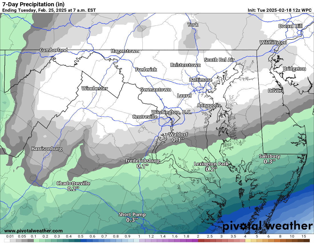
2/18/2025 – What a close call for a big storm. The following 2 days will show us what could have been. Southeastern Virginia will see close to a foot of snow. The upper-level energy that was, at one point, forecast to merge with the southern storm will come through Thursday and could coat the ground with some snow. How much? Maybe enough to whiten the ground. It will be cold!
This weekend, temperatures will recover, and it looks like a decent late winter weekend with highs in the 40s. Watching systems next week for some rain and snow chances, but nothing is organized until later on the models, which is too far off to be accurate.

The forecast:
Today: Hi 31 🌀️ Lo 16 ☁️ – Partly sunny and breezy, becoming mostly cloudy overnight with increasing clouds

Wednesday: Hi 29 🌨️ 20% Lo 20 🌨️ 30% – Cloudy with a slight chance of snow in the afternoon, increasing chances overnight

Thursday: Hi 31 🌨️40% Lo 20 πŸŒ™ – A chance of snow showers, mainly in the morning, then turning partly cloudy and blustery overnight

Friday: Hi 37 β˜€οΈ Lo 19 πŸŒ™ – Sunny and breezy, becoming mostly clear at night

Saturday: Hi 42 🌀️ Lo 26 πŸŒ™ – Mostly sunny, then partly cloudy overnight

Sunday: Hi 48 🌀️ Lo 30 ☁️ – Mostly sunny during the day, becoming mostly cloudy at night

Monday: Hi 49 β›… Lo 30 πŸŒ™- Partly sunny throughout the day

image.png

Loudoun County Weather Outlook for Monday, February 17, 2025

2/17/2025 – Cold and wintry feeling.. but just some snow possible on Wednesday. Wind advisory through midday. Overall, a boring week of weather. Cold and boring! πŸ™
The low that was expected Wednesday was shunted to the south by the strong low that caused our wind and a miss on phasing/linking with northern energy. That miss has allowed the storm to go south and east of us! Now we are left with a cold week and a waste of cold air at that! I am still sorry that I was so excited so early, but the models were in agreement on a big snow last Friday. It has been a long time since we missed a system that ended up being south of us!

The more extended range shows a return to normal temperatures and dry as well. The chances of more wintry weather is starting to diminish. We may see a few small systems next week that could cause a little snow, but not much support for big winter storms.

The forecast:
Today: Hi 37 🌀️ Lo 20 πŸŒ™ – Scattered morning flurries, then mostly sunny and windy with gusts up to 47 mph, becoming mostly clear and calmer overnight

Tuesday: Hi 34 🌀️ Lo 17 πŸŒ™ – Mostly sunny with breezy conditions, becoming partly cloudy overnight

Wednesday: Hi 25 🌨️50% Lo 18 🌨️50% – Mostly cloudy with a chance of snow throughout the day and night

Thursday: Hi 28 🌨️40% Lo 19 πŸŒ™ – A chance of morning snow, then mostly cloudy, becoming partly cloudy overnight

Friday: Hi 35 β˜€οΈ Lo 20 πŸŒ™ – Sunny and mostly clear

Saturday: Hi 38 🌀️ Lo 24 πŸŒ™ – Mostly sunny, becoming partly cloudy overnight

Sunday: Hi 43 🌀️ Lo 29 πŸŒ™ – Mostly sunny

#loudoun #loudouncountyva #vawx #loudounweather #loudounva #virginiaweather

Please support Tree of Life Ministries, an important organization to me! https://www.tolministries.org

Loudoun County Weather Outlook for Sunday, February 16, 2025

2/16/2025 – A very windy afternoon has prompted a High Wind Warning as the wind could gust to 60 mph. There are some showers and storms along the front, and they could also bring strong winds! The truly damaging winds should end this evening, but winds gusting into the 40s could continue through the first half of tomorrow!

We will get cold tonight, tomorrow, and Tuesday.

THEN – My attention is on Wednesday! This storm will likely NOT be as big of a deal for us as I once believed. Some factors could bring snow to the area, and it does have the potential to become more robust than what models are showing, but, as of now, a fluffy 2 to 5 inches seems possible. I know this is a far cry from what I have been sharing for the last 2 days, and I am sorry! I definitely was sold too early because of the unanimous model agreement, but the ensembles (a run of many different variations of the model) did say that I should be more cautious! And I did not listen! πŸ™ I am SO SORRY for the over-excitement!

Colder conditions should stick around into next weekend and then I am watching for when the pattern may turn milder. Snow chances after Wednesday may be done for the season.. but we will have to examine that more soon.

The forecast:
Today: Hi 54 🌦️70% Lo 27 πŸŒ™ – Showers likely before 3pm, then partly sunny and windy with gusts up to 60 mph.

Washington's Birthday: Hi 36 🌀️ Lo 21 πŸŒ™ – Mostly sunny and breezy with gusts up to 46 mph.

Tuesday: Hi 33 🌀️ Lo 18 πŸŒ™ – Mostly sunny with a northwest breeze.

Wednesday: Hi 25 🌨️60% Lo 19 🌨️70% – Snow likely in the afternoon

Thursday: Hi 28 🌨️40% Lo 18 πŸŒ™ – A chance of snow before 1pm, then partly sunny and blustery.

Friday: Hi 35 β˜€οΈ Lo 19 πŸŒ™ – Sunny during the day, with a partly cloudy night.

Saturday: Hi 36 🌀️ Lo 20 πŸŒ™ – Partly sunny throughout the day.

#loudoun #loudouncountyva #vawx #loudounweather #loudounva #virginiaweather

Please support Tree of Life Ministries, an important organization to me! https://www.tolministries.org

Loudoun County Weather Outlook for Friday, February 14, 2025

2/14/2025 – Colder today and breezy. Rain tomorrow (maybe a little mix at the start). Warmer, wet, and mild Sunday. Much colder next week! A big snow is possible later next week.
We will be windy today an feel the colder temps. Winds will die down through the day. After a cold night, we could have a mix of sleet and rain tomorrow. Warmer conditions will return Sunday before the front moves through, but it will be windy. Temps will be much colder next week. My snow-watching eyes are very much thinking that snow is coming in the middle of the week and there is the potential for a big snowstorm. BUT, this is so far off you cannot be sure that it will happen, that the big snow will be in our area, and it always has chances to change. The chance of snow continues to gain confidence.. it is the amounts and impact that remain unknown!

The forecast:
Today: Hi 38 β˜€οΈ Lo 26 ☁️ – Sunny with northwest winds and gusts up to 21 mph, becoming mostly cloudy overnight with light winds shifting southeast

Saturday: Hi 36 🌨️100% Lo 32 🌧️100% – Snow and sleet changing to rain in the afternoon, continuing as rain overnight with gusty south winds

Sunday: Hi 57 🌧️90% Lo 28 β˜οΈπŸŒ™ – Rain with gusty south winds shifting west, becoming partly cloudy overnight

Washington's Birthday: Hi 35 🌀️ Lo 19 πŸŒ™ – Mostly sunny and cold with a clear night

Tuesday: Hi 32 🌀️ Lo 18 ☁️ – Mostly sunny, becoming mostly cloudy overnight

Wednesday: Hi 31 🌨️30% Lo 19 🌨️50% – Mostly cloudy with a chance of snow during the day and a higher chance of snow overnight

Thursday: Hi 30 🌨️50% Lo 20 🌨️50% – Mostly cloudy with a chance of snow

#loudoun #loudouncountyva #vawx #loudounweather #loudounva #virginiaweather

Please support Tree of Life Ministries, an important organization to me! https://www.tolministries.org